Storm Speculation 1/25 - 1/26/11
|
This post was updated on .
Harvey asked me to do it...although I don't see it but remember Tuesday is Roll Back the Clock Day at MRG...if this hits early, that's where I'll be
MODELS DISAGREE REGARDING MONDAY NIGHT AND TUESDAY. ALL MODELS LOOK TO GENERATE SOME KIND OF EAST COAST STORM...BUT THE TIMING INTENSITY...AND TRACK VARY WIDELY. THEREFORE AT THIS TIME WILL GO WITH HPC WHICH FORMS A WEAK LOW NEAR CAPE HATTERAS TUESDAY MORNING WITH A STRONGER LOW OVER NORTHERN FLORIDA. IT APPEARS TO BE CLOSEST TO THE GEM...AND TO A LESSER EXTENT... THE ECMWF. THE LOW OVER FLORIDA MOVES TO NEAR CAPE HATTERAS BY TUESDAY EVENING AND PRETTY MUCH CAPTURES THE ONE TO THE NORTH AS IT INTENSIFIES. IT IS THEN FORECAST TO MOVE TO SOUTH OF LONG ISLAND BY WEDNESDAY MORNING...AND CONTINUE TO THE GULF OF SAINT LAWRENCE BY THURSDAY MORNING...WITH A WEAK RIDGE OF HIGH PRESSURE MOVING IN FROM CANADA AS THE LOW PASSES BY. LOWS MONDAY NIGHT WILL AGAIN BE COLD...ESPECIALLY NORTH WHERE CLOUDINESS WILL BE THINNEST...RANGING FROM AROUND 15 BELOW NORTH TO AROUND 5 ABOVE SOUTH. ON TUESDAY...THE ECMWF SPREADS PRECIPITATION INTO THE REGION AHEAD OF THE SYSTEM OFF THE CAROLINA COAST. THE PRECIP WILL START AS SNOW AND SHOULD REMAIN AS SNOW MUCH OF THE DAY. TEMPERATURES WILL MODERATE SOME WITH HIGHS GENERALLY IN THE 20S. WITH AN 850 HPA FLOW OFF THE OCEAN AND SURFACE WINDS FROM THE NORTH OR EAST...COLD AIR IS LIKELY TO BE TRAPPED UNDER THE WARMER AIR ALOFT...RESULTING IN THE POSSIBILITY OF SLEET OR FREEZING RAIN FOR A WHILE TUESDAY NIGHT. AT PRESENT WE ARE NOT LOOKING FOR THE WARM NOSE TO GET FAR ENOUGH NORTH TO AFFECT THE CAPITAL REGION. LOWS TUESDAY NIGHT WILL RANGE FROM NEAR ZERO IN THE FAR NORTH TO AROUND 20 SOUTH. ON WEDNESDAY COOLER AIR MOVES IN ALOFT WHICH WOULD CHANGE FREEZING PRECIP BACK TO SNOW...EXCEPT IN THE MID HUDSON REGION WHERE IT MAY GET WARM ENOUGH AT THE SURFACE FOR A BRIEF PERIOD OF MIX. HIGHS WEDNESDAY WILL RANGE FROM THE MID 20S TO THE MID 30S. AMOUNTS OF PRECIP ARE A TOSS UP AT THIS TIME...WITH THE ECMWF RATHER JUICY OVER LITCHFIELD COUNTY WITH OVER AN INCH OF LIQUID AND THE GFS WITH A TRACK FARTHER OFFSHORE HAVING HARDLY ANY PRECIP AT ALL. HAVE CHANCE POPS SOUTH AND WEST TUESDAY AND OVER THE ENTIRE AREA TUESDAY NIGHT AND WEDNESDAY.
Proud to call Gore My Home Mountain
Covid stole what would have been my longest season ever! I'll be back |
|
Administrator
|
Suds! My bad .... the message was txt'd and shortened. I meant to say ...
... if YOU with your vast meteopowers SEE qpf and potential, than please by all means post it up...! That goes for anybody - if you see potential in an event and want to start the speculation thread GO for it! I've been so busy I haven't been model following. Doh! 
"You just need to go at that shit wide open, hang on, and own it." —Camp
|
|
if you believe the GFS there is almost zero chance of any precip next Wed or Thurs..A bizillion more runs to go..
"Peace and Love"
|
|
I am trying to get the positive vibes going...I want to ski 46er on wednesday

Proud to call Gore My Home Mountain
Covid stole what would have been my longest season ever! I'll be back |
|
well the GFS is back on board with a supper sick looking system..This monster gets cut off and is load with qpf..I'm just a little nervous the low will cut off further west, thus sucking the low into NY state...Still many more runs to go..
"Peace and Love"
|
|
Well things are starting to look a LITTLE clearer..Just a little..All models show a pretty strong system moving up the east coast. The question is how far off the coast. The GFS keeps flip flopping , one run is a coast huger then next it's out to sea.
The NAM was the slowest and further west , bringing Rain to the coastal cities and a nice dump for all of the mountains..That said , the latest 12z run is a bit more progress and further east..There is great potential with this system..
"Peace and Love"
|
mmm I enjoy a nice dump! 
|
|
looks like a miss for all of the mountains on this one except for maybe the Cats and Berkshires..
"Peace and Love"
|
|
I see this one shifting inland. Gore will get some.
|
|
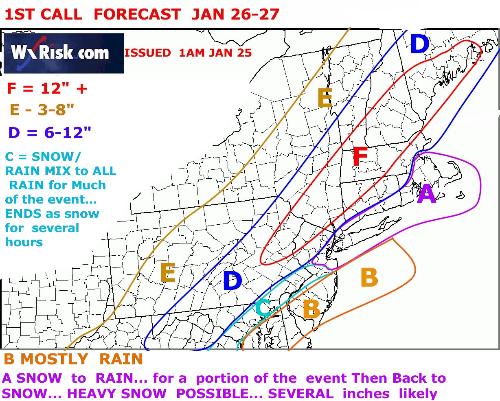
Saw this one over on TGR, any thoughts?

|
|
this is one of the most confusing events in a long time..good low position out at 40/70 ..but the upper air thermal profiles are critical, also there is a sharp precip cut off..right now all guess are right..
time will tell...
"Peace and Love"
|
|
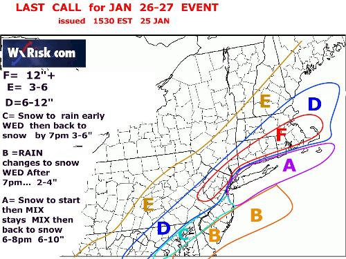
I'm in "E".....hope it happens
|
|
Fuj, hmmm Where'd they get that one from. I like it better than what the models are showing. The Euro is the only one that even comes close to Gore but not close enough. Right now looks like powder day at Jiminy, Catamount, Bosquet. This clipper is too weak and too fast to draw the new low inland...but I hope I'm wrong...still planning on Gore for Thursday.
Proud to call Gore My Home Mountain
Covid stole what would have been my longest season ever! I'll be back |
|
It still looks like this one will not have much impact on the ADK's. The southern Cats and Greens and Whites might do ok.
Either way I'm loving all the action.  This is the way winters should be. This is the way winters should be.
"Peace and Love"
|
«
Return to Weather Archive
|
1 view|%1 views


