|
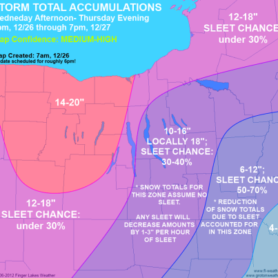
This is from my main man at Grotonweather.com
Good morning, everyone. We are all set for a major winter storm to start this afternoon, so let's get down to the details: - Snow develops across the area between 1-4pm and becomes heavy quickly. - During the afternoon, the center of the storm should transition from Kentucky to Virginia. The timing of this is critical and will be watched closely. A later/further north transition will mean a hig...her chance for sleet in our area overnight. - Very heavy snow overnight and early Thursday morning. The chances for sleet mixing in are in the 30-40% range. - 
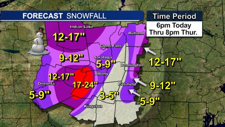
Every hour of sleet should reduce snow totals by 1-3". Assuming *no* sleet, accumulations of 8-14" are possible by morning. An additional few inches are possible Thursday, with storm totals of 10-16". - Winds will be gusty, but are not a major concern. Winds will lower already low visibilities and slightly worse already dangerous travel conditions. - Travel is highly discouraged after 4pm this afternoon through Thursday. I will be publishing a snow map shortly with additional updates, especially this afternoon. The critical time for the forecast is between 1-5pm when the low is supposed to transition. Check back for updates frequently during this time. Please Like, Comment on and Share my updates to help spread the news about this storm!
|
|
In reply to this post by gorgonzola
You gonna be there over the weekend??? If so, I'll look fer ya on sunday. |
|
In reply to this post by pro2860
I'll probably stop at Orion's at 11.00 for coffee, hope to catch first chair, or damn close, maybe I'll ride up with camo John...can't wait! |
|
Administrator
|
This post was updated on .
The 48 hour WRF seems to back up Lionel's idea that NY is in a good spot.
![]() I'm thinking of making this our new logo:
"You just need to go at that shit wide open, hang on, and own it." —Camp
|
|
FIS:
![]() WRGB ![]()
The day begins... Your mountain awaits.
|
|
Administrator
|
This post was updated on .
Nice maps. The first flakes are falling here in North River.
Looks like NWS has upped their call for our area: ![]() I also like the fact that the temps are dropping as the storm arrives. Don't see that often. ![]()
"You just need to go at that shit wide open, hang on, and own it." —Camp
|
|
Yep - just looked out the window as well here on the ridge above North Creek, it is snowing pretty well.
Just got through cleaning up the edges on ADKGurl's skis - my ski buddy and I are looking at a powder day. |
|
6:30AM and a good 8" has dropped here on the ridge above North Creek. It's not fluff, heavier than I would have hoped, it maybe lighter up on the rock. Today should be very fun. It's 22 degrees and still coming down. The plow guy is outside giving me a clear path to the mountain.
|
|
about 8" this morning in Jay. Tranny on the snow blower bit the dust. Calling the plow guy. Hopefully I can get to work.
if You French Fry when you should Pizza you are going to have a bad time
|
|
Administrator
|
This post was updated on .
Seems like more than that here (2000'). I'm guessing a foot between what I swept last night and what I just shoveled. Snowing at a good clip. Snow is 22° awesome IMO.
Boneheaded move, I forgot to put the car so it can just go downhill to the road. Should be interesting.
"You just need to go at that shit wide open, hang on, and own it." —Camp
|
This evenings report from the ever optimistic website is 15" total which is about what I have on my deck now. You may have been in a pocket that got more last night. I am one ridge over from Gore at an elevation of about 1300' |
