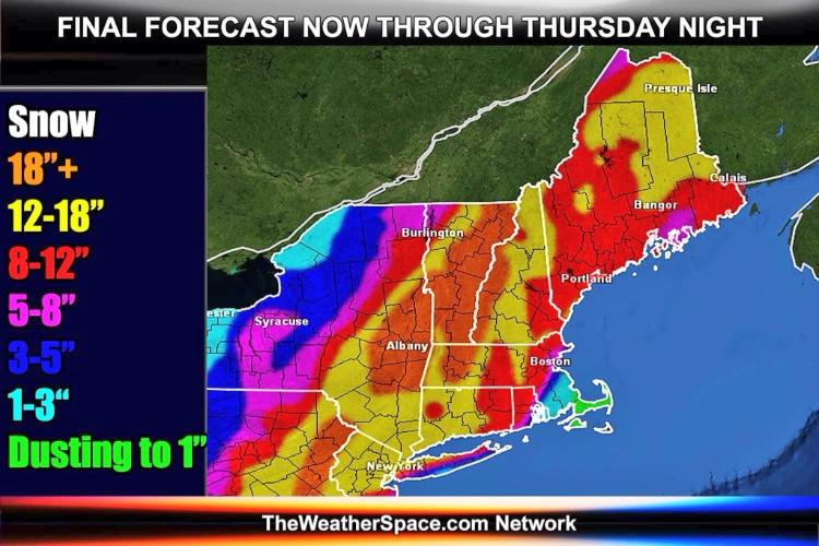
Don't say ANYTHING without your sumo avatar. WTF?
"They don't think it be like it is, but it do." Oscar Gamble
|
![]() I like this dude's map, and his discussion........ "The westward shift suggests heavy snow will extend back to the middle of Pennsylvania and then northeast to all of Vermont." Just a wee bit more west and the Dacks could be in the 6-12 zone. As this map has it now, looks like I may be in the 12-18 zone. Right now I think what this one does is anyone's guess still....as to where the exact track ends up, as to how much phasing occurs with the low coming across the lakes, how fast it comes up the coast. Lots of different maps out there. It will be a healthy storm for most......but could it BOMB and be a monster? Let's hope. |
|
Administrator
|
Certainly seems like bombing is a possibility. The storm track continues to look good on this model:
![]() (Noah did you figure out what model this is? WPC? is that a model?)
"You just need to go at that shit wide open, hang on, and own it." —Camp
|
|
WPC stands for Weather Prediction Center. I don't think that's a model. I think it's a forecast.
|
|
In reply to this post by Harvey
12z gfs drags in big time warm air... also there isn't a strong high in quebec
"Peace and Love"
|
|
.....which means a mixing of precip and a storm that moves through quick with nothing to block it?
Is the warm air indicative of a track a little more to the west/closer to the coast? Could that be good for the north country (push the precip further inland), assuming the warm air doesn't get that far? |
|
the 850 low is a little to close to the coast..that said , southern new england , ie: southern vt and nh might do quite well ..
the adk's are too far north and west to really benefit from this scenario .. this is one tough system to pin down..
"Peace and Love"
|
|
Hey Noah!!
|
|
Administrator
|
GFS seems to be moving inland...
"You just need to go at that shit wide open, hang on, and own it." —Camp
|
|
Models have definitely brought it inland. Burlington NWS 31 minutes ago:
SNOW/QPF: ONCE AGAIN EXTREMELY DIFFICULT TO DETERMINE EXACT SNOWFALL/QPF AMOUNTS GIVEN COMPLEX SYSTEM...SHARP GRADIENTS...AND IMPACTS OF MESO-SCALE BANDING. OUR BEST FCST ATTM SUGGESTS 6 TO 12 INCHES FOR MOST OF THE DACKS INTO THE CPV/NEK WITH 10 TO 16 INCHES POSSIBLE FOR MTNS OF CENTRAL VT. MEANWHILE...2 TO 6 INCHES POSSIBLE FOR SLV. ALSO DIFFICULT TO DETERMINE EXACT SNOWFALL RATIOS BUT THINKING 14 TO 1 FOR VALLEYS AND 18 TO 1 FOR MTNS ABOVE 1500 FEET. ALSO...WL HAVE TO WATCH FOR AN FURTHER SHIFT WEST IN SFC TRACK FOR POTENTIAL OF MIXED PRECIP IMPACTING OUR EXTREME SE ON THURSDAY NIGHT...AS 1000 TO 500 MB THICKNESS VALUE GET VERY CLOSE TO 540DAM. This is a nice storm. I like the pattern we're in here mid-Feb. Harv, isn't that next Tuesday's potential event? One at a time buddy....one at a time. |
|
A lot of snowfall maps that look like dicks are flying around.
Just saw this one on Facebook. If only it could be this way:
|
|
Administrator
|
In reply to this post by Noah John
I didn't realize there is potential for another event Monday night. By the way, you Whiteface guys... you have to make sure Coach doesn't ski this storm, he only likes clippers. No coastals. ![]()
"You just need to go at that shit wide open, hang on, and own it." —Camp
|
|
In reply to this post by MC2 5678F589
agree..and i'm color blind
"Peace and Love"
|
|
WIGGLE WOOT WIGGLE! O, yeah it worked and now NJ has to say WOOT WOOT!
I ride with Crazy Horse!
|
|
If you're bored and need to read more than that Sugarbush thread on the woodstove...check out the latest NWS forecast discussion from Albany...the jury is still out with this one and this forecaster tries to explain it...I hope this link works...
http://forecast.weather.gov/product.php?site=NWS&issuedby=ALY&product=AFD&format=CI&version=1&glossary=0&highlight=off
Proud to call Gore My Home Mountain
Covid stole what would have been my longest season ever! I'll be back |
|
Administrator
|
Link works. ![]() FYI: The Albany discussion and the major forecast discussions effecting NY are at the top of the NYSB Weather Page: ![]()
"You just need to go at that shit wide open, hang on, and own it." —Camp
|
|
Banned User
|
In reply to this post by MC2 5678F589
Uh.....WTH WAS THAT ? Commenting out(?) a phallic forecast, winged weather wangs ? .....that's some drift,,,, where you going with that ? Never mind. Didn't ask, don't tell. |
|
In reply to this post by Harvey
He's generally right. WF has a varied history with coastal storms. When they hit they're great and bring more snow than any other kind of storm but often these "historic" Nor'Easters wiff south and east, clobbering the I-95 cities and leaving us high, dry and very cold with big wind. Worse yet we get Lake Runners that come out of the Gulf and run up to our west leaving us on the warm and wet side. Some winters we just get clipper after clipper, 3-5" a shot. You don't hear about 'em in Jersey or Boston but they add up in the north country. And there's no such thing as a warm clipper; if they come in, they come in cold and snowy. That said, it's hard not to get excited about a major Nor'easter and this year they've treated WF well. So far. |
|
In reply to this post by MC2 5678F589
I'm not sure about the dicks part either but I like that yellow ribbon through warren county. I haven't seen anyone else calling for 12-18. Sure would be sweet. I have a big meeting at work tomorrow.....but I might be coming down with something. cough cough.
BTW it started snowing in saratoga about 7am this morning. It hasn't added up to much yet but its coming down pretty good. That's about 3 hours earlier than they were calling for. What's the matter Suds? You don't like reading about the misery in VT:) |
|
Administrator
|
"You just need to go at that shit wide open, hang on, and own it." —Camp
|
