Storm Speculation: 2/16/12
|
Administrator
|
Opinions from those who know?
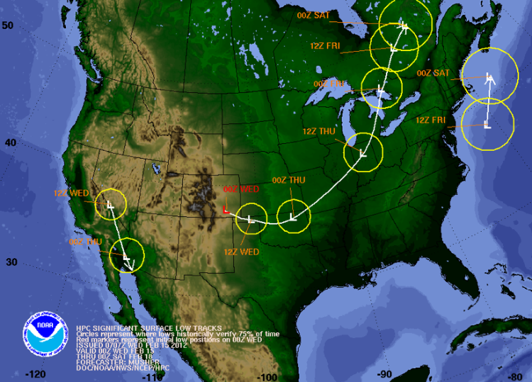
From NWS Albany Long-Term: Some uncertainty still exists in the long term period regarding the system which is expected to impact the area in the thursday afternoon into friday morning time frame. The ecmwf...gfs and ggem all differ in their handling of the h5 trof moving east from the the mississippi valley thursday morning. While a develop a negatively tilted trof oriented from the upper and eastern great lakes through the northeast towards the southern new england coast by friday morning...different amplitudes and slight variations in the orientation play a significant role in the track of the secondary surface low which will greatly impact the qpf produces across the aly fa. The ecmwf...and gfs are very similar in the position...strength and timing of the surface low tracks thursday through friday night while the canadian is slightly slower and has the primary and secondary surface lows passing much closer to the aly fa. ptype is expected to generally be rain in the valleys thursday afternoon through friday morning with the potential for some snow across the northwest portion of the fa as well as across the higher terrain generally above 1500 or 2000 feet.
"You just need to go at that shit wide open, hang on, and own it." —Camp
|
|
Local 4cast for Champlain Valley was harsh this morning. Calling for .25 -.50 of rain Th-Fri.... Waiting to see what LH and the ADK weather dude have to say before I throw in the towel for a Friday MoNat Pow day....
I ride with Crazy Horse!
|
|
This week may be a bust. Be on the lookout for a 2 footer between 2/23 and 3/04.
|
|
Administrator
|
Looks like the forecast has gotten slightly colder. I don't really understand the dynamics of this as the storm track looks ugly. I guess both lows are weak and that is "helping."
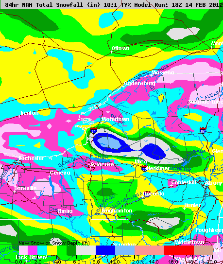
 I'll take the shred of hope. Here's NWS Albany: Thu-thu nt...Next feature is expected to approach from the southwest/west during thursday...As one weak low tracks into and across se canada...With an even weaker sfc low developing off the mid atlantic coast and tracking ene. Except for the nam... Models continue to forecast relatively light pcpn amounts (a third of an inch or less) across the region. Pcpn type is expected to be mainly snow north of the mohawk valley...With mainly rain from the mohawk valley south and rain/snow over the higher terrain. Snowfall accumulations will be about 1 to 4 inches across the north...And a dusting to a couple of inches south. Highs thursday will be in the mid 30s to mid 40s...And lows thursday night will be within a few degrees of 30.
"You just need to go at that shit wide open, hang on, and own it." —Camp
|
|
Local weather pulling back on amount of rain as well as throwing in the wet snow, so that's a plus. Also put out a heads up for possible Nor'easter Sun into Mon. Not pimping it big but they said it's tracking east which means if it does come we get SNOW!!!!!!!

I ride with Crazy Horse!
|
|
Administrator
|
Saw that ScottyJack. I figure if it's still in play after a few more model runs we'll give it it's own thread. Statistically even in very low snow year, there has to be at least one legit storm right?
"You just need to go at that shit wide open, hang on, and own it." —Camp
|
|
One be nice! One one next week and one the week after and so on and so on till May 1......

I ride with Crazy Horse!
|
«
Return to Weather Archive
|
1 view|%1 views


