Dec. 29-30th Storm

classic Classic list List threaded Threaded
19 messages Options
Reply | Threaded
Open this post in threaded view
|

Dec. 29-30th Storm

WNY-ADK Skier
How's everyone feeling about this one? Could be a nice moderate snowfall event if the stars align. Thoughts?
Reply | Threaded
Open this post in threaded view
|

Re: Storm Speculation Dec. 29-30/2013

Harvey
Administrator
I was wondering about that too:

http://forum.nyskiblog.com/Winter-Weather-2013-2014-tp4033843p4034001.html

Harvey wrote


"You just need to go at that shit wide open, hang on, and own it." —Camp
Reply | Threaded
Open this post in threaded view
|

Re: Storm Speculation Dec. 29-30/2013

snoloco
This post was updated on .
CONTENTS DELETED
The author has deleted this message.
I've lived in New York my entire life.
Reply | Threaded
Open this post in threaded view
|

Re: Storm Speculation Dec. 29-30/2013

Chris
I haven't seen anyone else comment on it around- nothing from Darrin @ ILsnow or FIS.  I think FIS did say we may get a 1-3" event this weekend
The day begins...  Your mountain awaits.
Reply | Threaded
Open this post in threaded view
|

Re: Storm Speculation Dec. 29-30/2013

WNY-ADK Skier
Reply | Threaded
Open this post in threaded view
|

Re: Storm Speculation Dec. 29-30/2013

Harvey
Administrator
This was looking 100% ugly this morning but has been downgraded to a mess.

NWS ALB:

SUNDAY-SUNDAY NIGHT...

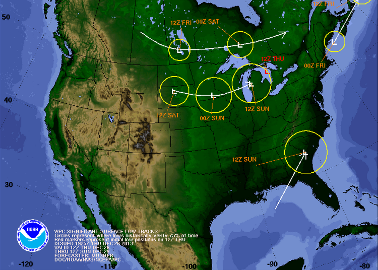
This is the active portion of the forecast as a low pressure system tracks north up the eastern seaboard to near eastern long island sunday evening at the same time an arctic cold front will be moving into the eastern great lakes region.

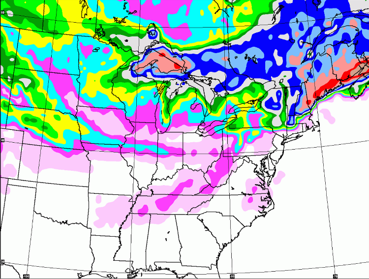
The sref plume diagrams for alb indicate mostly rain with a few members showing snow. There is also considerable spread in the opf amounts from around 0.40 inches to 1.60 inches with a clustering around an inch. The sref probability of ptype fields show rain across the area until btwn 21z and 00z with a changeover to mostly if not all snow by 03z.

This system also had some frontogenic forcing along the nr coast around 00z. The bottom line is that rain is expected to break out from southwest to northeast sunday afternoon and then transition to snow in most places after dark.

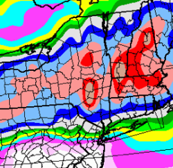
Most areas can expect 1 to 3 inches of snow with 3 to 6 inches across the southern green mountains. Have not issued an advisory at this time as confidence is rather low regarding how much pcpn will fall as snow and how much as rain.

Expect highs on sunday to be in the mid 30s to lower 40s with lows sunday night in the teens to mid 20s.
"You just need to go at that shit wide open, hang on, and own it." —Camp
Reply | Threaded
Open this post in threaded view
|

Re: Storm Speculation Dec. 29-30/2013

Harvey
Administrator
This storm track looks ideal for this time of year but the cold air is  just a little behind...

"You just need to go at that shit wide open, hang on, and own it." —Camp
Reply | Threaded
Open this post in threaded view
|

Re: Storm Speculation Dec. 29-30/2013

evergreen
I had to work this weekend, but not next weekend:)

Image through next Sat!
Reply | Threaded
Open this post in threaded view
|

Re: Storm Speculation Dec. 29-30/2013

Harvey
Administrator
Change over here in So Adk began around 3:15, snow mixing in.

More snow than rain now and slush is starting to build up.

Roads are slick.
"You just need to go at that shit wide open, hang on, and own it." —Camp
Reply | Threaded
Open this post in threaded view
|

Re: Storm Speculation Dec. 29-30/2013

NorEaster27
whats the report from north creek, raining in bolton landing...33 degrees
Reply | Threaded
Open this post in threaded view
|

Re: Storm Speculation Dec. 29-30/2013

poindexter
No changeover yet-it's coming down pretty hard outside my window in North Creek. It was snowing above the saddle and raining below this afternoon, so maybe the top of the mountain will get a lot by tomorrow.
Reply | Threaded
Open this post in threaded view
|

Re: Storm Speculation Dec. 29-30/2013

NorEaster27
This is over by midnight we are running out of time
Reply | Threaded
Open this post in threaded view
|

Re: Storm Speculation Dec. 29-30/2013

Harvey
Administrator
Have to agree that unless it gets colder now, we won't see much accumulation.

What's falling isn't fully sticking.

Mountain tops excepted.  Inversion is gone.
"You just need to go at that shit wide open, hang on, and own it." —Camp
Reply | Threaded
Open this post in threaded view
|

Re: Storm Speculation Dec. 29-30/2013

JasonWx
Glad I'm sitting in sunny so cal and not involved with that weather mess.  
"Peace and Love"
Reply | Threaded
Open this post in threaded view
|

Re: Storm Speculation Dec. 29-30/2013

NorEaster27
finally sticking in lake george but only 2 hrs left, so maybe 2 inches by the end.  I would assume the summit picked up 2-4 inches (at least i hope)
Reply | Threaded
Open this post in threaded view
|

Re: Storm Speculation Dec. 29-30/2013

Goreskimom
Snowing and sticking in North Creek.
Reply | Threaded
Open this post in threaded view
|

Re: Storm Speculation Dec. 29-30/2013

WNY-ADK Skier
Nothing falling from the sky in WF thru the day and up till the lifts stopped turning. Raining on the shuttle ride back to lake placid. Raining in lake placid from 4:30 until about half an hour ago when it started changing over. Seems to be snow now, but it's kind of switching from rain to snow.

Seemed to be below freezing all day at the summit, given that they were making snow on Skyward all day. So the summit was likely seeing frozen precip from the outset....which probably was 430 to 5ish.
Reply | Threaded
Open this post in threaded view
|

Re: Storm Speculation Dec. 29-30/2013

NorEaster27
WF couldnt have had more than an inch it was warm and little precip.  Gore probably got 1-2 with maybe 2-4 on Summit, storm is over now.
Reply | Threaded
Open this post in threaded view
|

Re: Storm Speculation Dec. 29-30/2013

snoloco
This post was updated on .
r*in sucks
I've lived in New York my entire life.