First Winter Storm Watch 10/11

classic Classic list List threaded Threaded
18 messages Options
Reply | Threaded
Open this post in threaded view
|

First Winter Storm Watch 10/11

Harvey
Administrator
The WRF may definitely need to be interpreted. It gives information, but those amounts are very likely to be high. Jason can chime in as to WHY this is, but I know it to be true from experience.

* * *

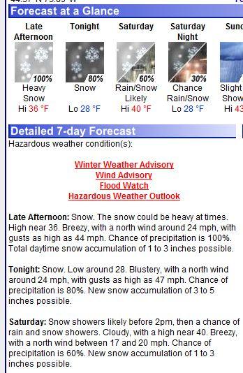
First Winter Storm Watch from NWS Albany since April 26:

URGENT - WINTER WEATHER MESSAGE
NATIONAL WEATHER SERVICE ALBANY NY
412 PM EDT THU OCT 14 2010


...WINTER STORM WATCH IN EFFECT FROM FRIDAY MORNING THROUGH SATURDAY AFTERNOON...

THE NATIONAL WEATHER SERVICE IN ALBANY HAS ISSUED A WINTER STORM WATCH FOR ELEVATIONS ABOVE 2000 FEET...WHICH IS IN EFFECT FROM FRIDAY MORNING THROUGH SATURDAY AFTERNOON ACROSS THE SOUTHERN ADIRONDACKS ...NORTHEAST CATSKILLS ...AND HELDERBERGS ...THE SOUTHERN GREEN MOUNTAINS ...AND NORTHERN BERKSHIRES.

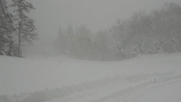
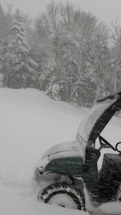
RAIN IS EXPECTED TO MIX WITH...AND EVENTUALLY CHANGE TO WET SNOW ACROSS HIGHER ELEVATIONS WITHIN THE WATCH AREA ...BEGINNING FRIDAY MORNING ACROSS THE SOUTHERN ADIRONDACKS AND NORTHEAST CATSKILLS ...AND ACROSS THE SOUTHERN GREEN MOUNTAINS AND NORTHERN BERKSHIRES FRIDAY AFTERNOON. PERIODS OF SNOW ...POSSIBLY HEAVY AT TIMES ...WILL CONTINUE INTO FRIDAY NIGHT ...BEFORE GRADUALLY TAPERING OFF SATURDAY.

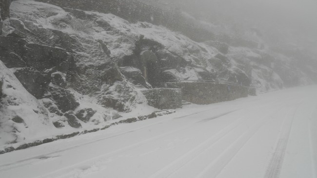
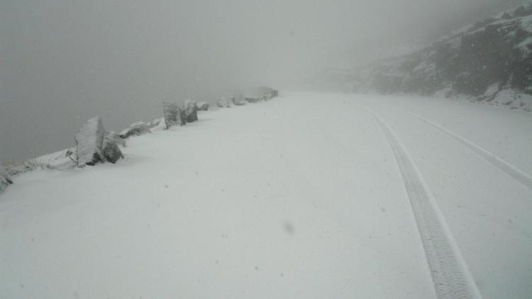
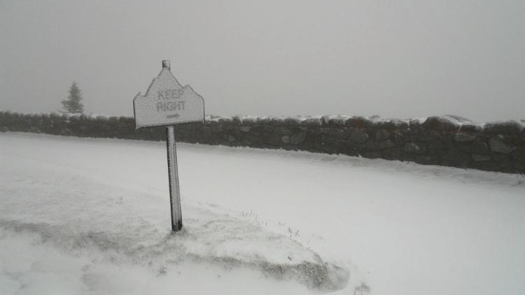
THE POTENTIAL EXISTS FOR SNOWFALL ACCUMULATIONS OF 7 INCHES OR GREATER WITHIN THE WATCH AREA. THE WEIGHT OF WET SNOW MAY BRING DOWN TREE LIMBS ...ESPECIALLY IN AREAS WHERE LEAVES REMAIN. THIS MAY RESULT IN SOME POWER OUTAGES.

"You just need to go at that shit wide open, hang on, and own it." —Camp
Reply | Threaded
Open this post in threaded view
|

Re: First Winter Storm Watch 10/11

Snowballs
Banned User
Just saw on the Weather Channel, 12:00 pm, It's snowing in Vermont. They got a Reporter at Stowe, where it's snowing above 3000'. 2" so far. Expecting 8" on the northern slopes. It's also snowing at Killington, 2", and there's even snow on the base buildings. It's snowing as low as 700' elevation in Vermont.

Just NCP here at exit 18, 465' elevation and the temp's 40 degrees.
Reply | Threaded
Open this post in threaded view
|

Re: First Winter Storm Watch 10/11

Harvey
Administrator
The intellicast radar is the "most sensitive" color coded radar. I don't use it on the HR homepage for reasons I'll explain another time. At the time of this posting, it is backing up the Tweets coming out of Kmart and Stowe:

"You just need to go at that shit wide open, hang on, and own it." —Camp
Reply | Threaded
Open this post in threaded view
|

Re: First Winter Storm Watch 10/11

JasonWx
Forecast is still on track..No real surprises, 2-6 inch for upper elevations..
"Peace and Love"
Reply | Threaded
Open this post in threaded view
|

Re: First Winter Storm Watch 10/11

70s Gore Kid
Check out The Weather Channel Friday afternoon:  Jim Cantore is reporting live from the base of Stowe, holding up a snowball he just made, and predicting 4 - 6 inches in higher elevations.  As I said on Harv's Blog side a moment ago, I know this is a NY ski forum, but I'm pretty excited and that's all this old Kid can find at this point!
Syracuse, NY
Reply | Threaded
Open this post in threaded view
|

Re: First Winter Storm Watch 10/11

tBatt
In reply to this post by JasonWx
Jason, is that supposed to be a total for the whole storm or just what they've gotten so far?

Above is forecast for Whiteface.
Reply | Threaded
Open this post in threaded view
|

Re: First Winter Storm Watch 10/11

JasonWx
it looks like NWS 's forecast is for 5-11...sounds reasonable..
"Peace and Love"
Reply | Threaded
Open this post in threaded view
|

Re: First Winter Storm Watch 10/11

MC2 5678F589
In reply to this post by tBatt
Whiteface looks like the Sweet Spot.  I'll be on the Auto Road tomorrow.
Reply | Threaded
Open this post in threaded view
|

Re: First Winter Storm Watch 10/11

JasonWx
looks like Vermont is winding down..Whiteface is definitely in the Sweet Spot..

I don't like cold Octobers. Kind of sets us up for a warm November..
"Peace and Love"
Reply | Threaded
Open this post in threaded view
|

Re: First Winter Storm Watch 10/11

Highpeaksdrifter
In reply to this post by MC2 5678F589
mattchuck2 wrote
Whiteface looks like the Sweet Spot.  I'll be on the Auto Road tomorrow.
Not sure what time pic was taken:

There's truth that lives
And truth that dies
I don't know which
So never mind - Leonard Cohen
Reply | Threaded
Open this post in threaded view
|

Re: First Winter Storm Watch 10/11

Harvey
Administrator
Highpeaksdrifter wrote
Not sure what time pic was taken...
I'm thinking mid to late morning ... maybe just before these:

Whiteface Memorial Highway 1

Whiteface Memorial Highway 2
"You just need to go at that shit wide open, hang on, and own it." —Camp
Reply | Threaded
Open this post in threaded view
|

Re: First Winter Storm Watch 10/11

Highpeaksdrifter
Reply | Threaded
Open this post in threaded view
|

Re: First Winter Storm Watch 10/11

Harvey
Administrator
Powderqueen has forwarded two reports from Ski-VT.  

Killington has 18" at the summit 6" at the base.

6" at 3600 feet on Mansfield with snow levels dropping.

I'm assuming these reports must be at least a few hours old.

What an awesome storm!
"You just need to go at that shit wide open, hang on, and own it." —Camp
Reply | Threaded
Open this post in threaded view
|

Re: First Winter Storm Watch 10/11

tBatt
Whiteface is looking pretty nice right about now..

earlier today:


I'll be heading up in a few hours with Matt, his wifey, and a friend.

on another note, is this your dog? He's adorable, but I wish he hadn't kept me up till 4:30 in the morning trying to find his owner. I have such a day ahead of me!
Reply | Threaded
Open this post in threaded view
|

Re: First Winter Storm Watch 10/11

JasonWx
It looks like Whiteface was the big winner. Though I can't find any totals. I wouldn't believe a ob out of kiillington if my life depended on it. Just checked the Stowe cam , quite a bit of rain at the base with a little snow..
Zero snow for the Cats..MGR looks to have received a few inch's based on the web cam..
"Peace and Love"
Reply | Threaded
Open this post in threaded view
|

Re: The Weather Thread 10/11

Harvey
Administrator
This is kinda fun. While we obviously had some significant snow last week, this is a real winter type radar shot. I like it:

NY Radar

I asked Jason about next week. He said "don't ask."
"You just need to go at that shit wide open, hang on, and own it." —Camp
Reply | Threaded
Open this post in threaded view
|

Arctic Report Card

Denis.N
NOAA issued Arctic Report Card 2010
 
Check out at the bottom of Atmosphere section :

While individual weather extreme events cannot be directly linked to larger scale climate changes, recent data analysis and modeling suggest a link between loss of sea ice and a shift to an increased impact from the Arctic on mid-latitude climate (Francis et al. 2009; Honda et al. 2009). Models suggest that loss of sea ice in fall favors higher geopotential heights over the Arctic. With future loss of sea ice, such conditions as winter 2009-2010 could happen more often. Thus we have a potential climate change paradox. Rather than a general warming everywhere, the loss of sea ice and a warmer Arctic can increase the impact of the Arctic on lower latitudes, bringing colder weather to southern locations.
Reply | Threaded
Open this post in threaded view
|

Experimental Mountain Point Forecast

Denis.N
Looks like very useful "Experimental Mountain Point Forecast" (originally posted by 'Skier 4 Life' on SkiAdk board)