Loading... |
Reply to author |
Edit post |
Move post |
Delete this post |
Delete this post and replies |
Change post date |
Print post |
Permalink |
Raw mail |
![]() ![]() ![]() ![]() ![]() ![]() ![]() |
This post was updated on Oct 20, 2017; 7:49pm.
CONTENTS DELETED
The author has deleted this message.
|
Loading... |
Reply to author |
Edit post |
Move post |
Delete this post |
Delete this post and replies |
Change post date |
Print post |
Permalink |
Raw mail |
![]() ![]() ![]() ![]() ![]() ![]() ![]() |
Its amazing how long some of the new slides are in these photos - some look miles long
a few look way too steep to hold snow and be safely skiable
A true measure of a person's intelligence is how much they agree with you.
|
Loading... |
Reply to author |
Edit post |
Move post |
Delete this post |
Delete this post and replies |
Change post date |
Print post |
Permalink |
Raw mail |
![]() ![]() ![]() ![]() ![]() ![]() ![]() |
Saw those today. That Lower Wolfjaw looks like it could be a pretty damn long run. Is that doable in a day?
|
Loading... |
Reply to author |
Edit post |
Move post |
Delete this post |
Delete this post and replies |
Change post date |
Print post |
Permalink |
Raw mail |
![]() ![]() ![]() ![]() ![]() ![]() ![]() |
Administrator
|
![]() Photo courtesy of adkbcski.com
"You just need to go at that shit wide open, hang on, and own it." —Camp
|
Loading... |
Reply to author |
Edit post |
Move post |
Delete this post |
Delete this post and replies |
Change post date |
Print post |
Permalink |
Raw mail |
![]() ![]() ![]() ![]() ![]() ![]() ![]() |
In reply to this post by MC2 5678F589
Matt, that LWJ slide is essentially an enlargement of the former Bennie's Brook slide, which I hiked last summer. The older y-shaped portion is visible to the left in the photo, the new stuff is the lighter colored rock that extends almost all the way to LWJ's summit. The old slide was pretty long, but it looks like it has now been extended clear down to John's Brook and the Southside trail. Bennie's Brook has been a pretty popular backcountry ski trip for years, to me it looks even more doable now, pending any issues with debris.
|
Loading... |
Reply to author |
Edit post |
Move post |
Delete this post |
Delete this post and replies |
Change post date |
Print post |
Permalink |
Raw mail |
![]() ![]() ![]() ![]() ![]() ![]() ![]() |
In reply to this post by Harvey
I tried matching the shot above in Google Earth to give a better idea of how the Bennies Brook Slide has changed as a result of Irene. The slide looks to now intersect the southern John's Brook trail making the approach even easier than it was before.
![]() |
Loading... |
Reply to author |
Edit post |
Move post |
Delete this post |
Delete this post and replies |
Change post date |
Print post |
Permalink |
Raw mail |
![]() ![]() ![]() ![]() ![]() ![]() ![]() |
In reply to this post by MC2 5678F589
Yes. Here's a view from the top ![]() |
Loading... |
Reply to author |
Edit post |
Move post |
Delete this post |
Delete this post and replies |
Change post date |
Print post |
Permalink |
Raw mail |
![]() ![]() ![]() ![]() ![]() ![]() ![]() |
Excellent. On the list for next year. I was trying to figure out how long the round trip is from the parking lot. Looks to be about 8-10 miles? Should be good to go with an early start. And yes, it looks like the slide has been extended all the way to the trail back to the parking area. Sick.
|
Loading... |
Reply to author |
Edit post |
Move post |
Delete this post |
Delete this post and replies |
Change post date |
Print post |
Permalink |
Raw mail |
![]() ![]() ![]() ![]() ![]() ![]() ![]() |
This post was updated on Sep 02, 2011; 3:11am.
In reply to this post by Adk Jeff
The new slide on Saddleback looks particularly interesting. It should be easily accessible from the Ore Bed Brook trail, it is of substantial length, and it almost goes to the summit.
After Irene shot from adkbcski.com ![]() Before Irene from Google Earth: ![]() |
Loading... |
Reply to author |
Edit post |
Move post |
Delete this post |
Delete this post and replies |
Change post date |
Print post |
Permalink |
Raw mail |
![]() ![]() ![]() ![]() ![]() ![]() ![]() |
Administrator
|
Those are some beautiful photographs. Thanks everyone for posting, and thanks to Drew for letting me use that pic.
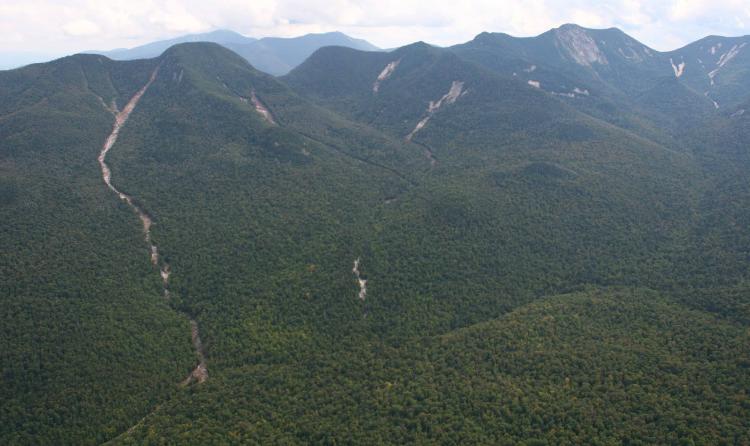
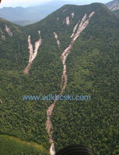
Jeff or anyone - what is the total vert on the slide, and how much of that is pitched enough for linked turns? Does anyone else feel weird about looking at these pics? I was thinking that if we all got together, for massive breakfast at a local place, and again went out locally for dinners and beer after an epic daylong ski, we could bring a little business to the High Peaks and put a positive spin on a small part of the story. Bet we could get some bloggers interested.
"You just need to go at that shit wide open, hang on, and own it." —Camp
|
Loading... |
Reply to author |
Edit post |
Move post |
Delete this post |
Delete this post and replies |
Change post date |
Print post |
Permalink |
Raw mail |
![]() ![]() ![]() ![]() ![]() ![]() ![]() |
Great pics Take-a-hike and SkiMore. The comparison really shows well how much further BB has been extended.
Harv, vert on the new extended version must be damn near 2000 feet now, and yes, it does feel a bit odd looking at those pics. The Saddleback slide looks like the upper third might be a bit steep, or maybe I'm just a whimp. You're absolutely right about spending some $$ in the Keene Valley region asap - important aspect of recovering and restoring some normalcy. |
Loading... |
Reply to author |
Edit post |
Move post |
Delete this post |
Delete this post and replies |
Change post date |
Print post |
Permalink |
Raw mail |
![]() ![]() ![]() ![]() ![]() ![]() ![]() |
Time for a new slide guide!
|
Loading... |
Reply to author |
Edit post |
Move post |
Delete this post |
Delete this post and replies |
Change post date |
Print post |
Permalink |
Raw mail |
![]() ![]() ![]() ![]() ![]() ![]() ![]() |
This post was updated on Sep 04, 2011; 3:13am.
In reply to this post by Harvey
Harv, I feel the same way but then also fascinated by the power of Mother Nature. It might be a cliche but with every cloud there is a silver lining. We certainly can't change what happened so we might as well embrace it. I like the idea of getting up there and spending some money and skiing. This way it can be a win-win for everybody. Hopefully the good people of the region will be able to recover. Here's wishing them lots of luck!
|
Loading... |
Reply to author |
Edit post |
Move post |
Delete this post |
Delete this post and replies |
Change post date |
Print post |
Permalink |
Raw mail |
![]() ![]() ![]() ![]() ![]() ![]() ![]() |
Administrator
|
Don't get me wrong - I feel the pull of those images. I thought Jeff's intro in his blog piece said it pretty well.
"You just need to go at that shit wide open, hang on, and own it." —Camp
|
Loading... |
Reply to author |
Edit post |
Move post |
Delete this post |
Delete this post and replies |
Change post date |
Print post |
Permalink |
Raw mail |
![]() ![]() ![]() ![]() ![]() ![]() ![]() |
Some amazing pictures from the Johns Brook Valley:
http://www.brendanwiltse.com/Photography_Site/My_Albums/Pages/JBL_-_Hurricane_Irene.html |