Storm Speculation: 1/12/11
12
12
|
Administrator
|
NATIONAL WEATHER SERVICE ALBANY NY
430 AM EST SUN JAN 9 2011 .LONG TERM /TUESDAY NIGHT THROUGH SATURDAY/... THE MAIN FOCUS AND FORECAST CHALLENGE FOR THE PERIOD WILL BE A POTENTIAL WINTER STORM ASSOCIATED WITH A NOR`EASTER MOVING UP THE EASTERN SEABOARD TUESDAY NIGHT INTO WEDNESDAY. THERE IS NOW LITTLE DOUBT THAT A STORM WILL EMERGE ALONG THE EAST COAST AND DEVELOP INTO A NOR`EASTER...HOWEVER THE EXACT STORM TRACK WHICH WILL PLAY A BIG ROLE IN DETERMINING SNOWFALL AMOUNTS... LOOKING AT THE VARIOUS SOURCES OF MODEL GUIDANCE...THE ECMWF IS MOST AGGRESSIVE WITH TRACKING THE NOR`EASTER CLOSER TO CAPE COD WHICH WOULD RESULT IN A GREATER THREAT OF HEAVY SNOWFALL FOR AT LEAST A PORTION OF OUR AREA. THE TRACK FROM GFS IS THE FARTHEST EAST OF THE OPERATIONAL GUIDANCE...WHILE THE GGEM IS SLIGHTLY WEST OF THE GFS POSITION. HOWEVER...THE GFS ENSEMBLES SHOW CLUSTERING OF LOW PRESSURE NEAR CAPE COD...AND EVEN THE MEAN POSITION IS WEST OF THE OPERATIONAL GFS. THE ECMWF IS DEPICTING THE OHIO VALLEY UPPER TROF AS STRONGER...WHICH WOULD TEND TO CAPTURE THE NOR`EASTER AND RESULT IN A MORE WESTWARD TRACK. THE GFS IS MUCH WEAKER WITH THE TROF AT THIS TIME. THE STRENGTH OF THE UPSTREAM TROF WILL LIKELY HAVE A BIG IMPACT ON THE TRACK OF THE NOR`EASTER. SO AT THIS TIME THERE IS ENOUGH CONFIDENCE TO CONTINUE TO MENTIONING THE THREAT FOR HEAVY SNOWFALL IN THE HWO. THE 12Z GEFS PROBABILITY OF 0.50" QPF IS GREATEST ACROSS NEW ENGLAND...BUT WITH CHANCE VALUES BACK INTO EASTERN NY TOO. THIS SYSTEM BEARS WATCHING FOR A POTENTIAL HEAVY SNOWFALL. 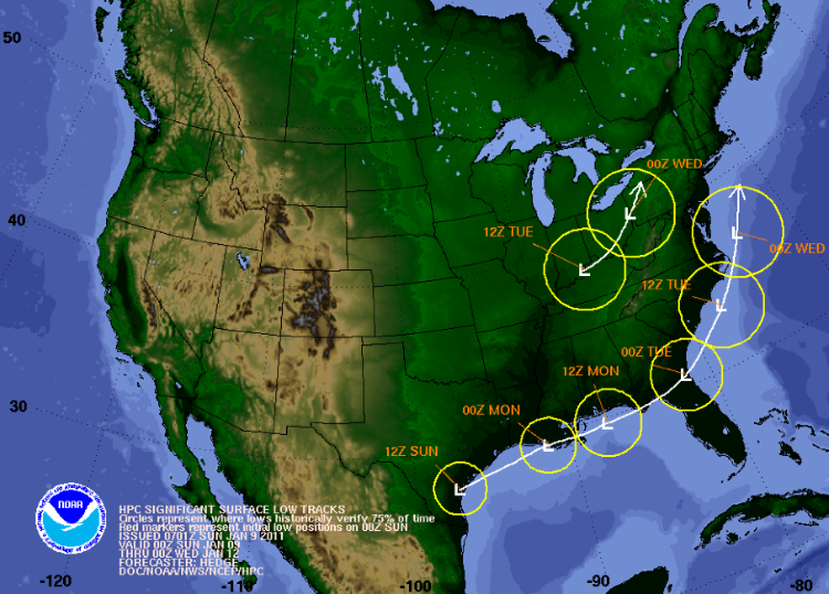
"You just need to go at that shit wide open, hang on, and own it." —Camp
|
|
this could be a nice moderate event for everyone..more on it later after 12z gfs comes out..NAM so far is the most robust..
"Peace and Love"
|
|
People lets hope the NAM is correct! Oz and 6z NAM have powerful low hugging the coast and tracking through Eastern L.I. just east of Boston. With this track everyone is invited to the party. Yes, even Gore should receive a substantial dump.
The GFS on the other hand is little further to the east with it's low and is less intense. This scenario would bring more snow to the Cats and Eastern New England....Still many more runs to iron out the details..
"Peace and Love"
|
|
NAM looks like a western outlier...I would go with the GFS / Euro in this storm. I dont see Gore getting much snow out of this, maybe 2-4.
|
|
NAM looks like a western outlier...I would go with the GFS / Euro in this storm. I dont see Gore getting much snow out of this, maybe 2-4. <quote author="NorEaster27">
i'm starting to agree
"Peace and Love"
|
|
Administrator
|
This post was updated on .
What about the Cats? 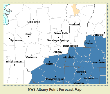
"You just need to go at that shit wide open, hang on, and own it." —Camp
|
|
We are less than 24 hrs away and still have a world of difference in QPF between the NAM and the GFS.
|
|
We are less than 24 hrs away and still have a world of difference in QPF between the NAM and the GFS.
i was talking to Harv about that last night..i don't trust any of the models..
"Peace and Love"
|
|
I am trying to ignore this one and hope it is all over by tomorrow evening. I won't have a chance to ski tomorrow and I want the runway clear at Albany Airport Thursday morning...early. I am going to take a stab at it anyway. I do think the Berkshires and Greens will be the winners with the bullseye just east of us (Gore). I still think they will get 5-10 (I know big spread). It is dusting here in Saratoga now and it is not even showing up on radar. As with all of the recent storms it all depends on where it sets up and deepens. My guess just off Long Island
Proud to call Gore My Home Mountain
Covid stole what would have been my longest season ever! I'll be back |
|
In reply to this post by JasonWx
This storm would be better for me it somehow avoided the city, so I can easily make it up to the mountains this weekend. Either way I woulod love to see another 10-12 inches fall in the cats and the same at gore and southern vt. But more importantly, I would love to see this cold weather stick through march so we can avoid any thaws. That I believe is going to help with conditions more than anything else.
Rob
|
|
Administrator
|
"You just need to go at that shit wide open, hang on, and own it." —Camp
|
|
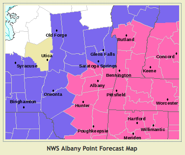
Forecast for Gore has been upped from 1"-2" in yesterday model, to 3" this morning and now to 4":
http://www.erh.noaa.gov/aly/Past/Snow_PNS/WSW.htm It resembles last Saturday's development  |
|
Administrator
|
Looks like the low may be a bit closer to the coast than anticipated.
(Fingers crossed emoticon here).
"You just need to go at that shit wide open, hang on, and own it." —Camp
|
|
funny you say that, i was thinking about chopping the accumulations..starting to think development might be later rather than sooner..time will tell...this system has NWS forecasting a wide spread of accumulations..
"Peace and Love"
|
|
Administrator
|
I just assumed that the expanding WWA and WSW zones meant the low was closer in and the Cats / Daks might get more:
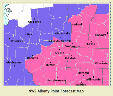 What's actually going on?
"You just need to go at that shit wide open, hang on, and own it." —Camp
|
|
Fox news said 8 to 12 in the adks. Lets hope. We need it.
|
|
now I'm just going from the radar, but the rotation is starting to look pretty defined and it looks to be setting up further north but also further inland. The low that is supposed to transfer its energy looks pretty strong coming across western PA. This is a really cool storm to follow...I wish I was skiing Wildcat on Thursday...I have a hunch Gore is going to do fairly well but not the bullseye...much like the last storm, another near miss but a lot of fun
Just peeked at the weather channel and they have it further east...still fun at Wildcat not so much for Gore...For the fellow Gore skier I hope I am closer then them...but I unfortunately won't be there...Have fun Duck
Proud to call Gore My Home Mountain
Covid stole what would have been my longest season ever! I'll be back |
|
Snowing here in Ballston Spa.
|
|
Administrator
|
This is turning out to be another nice little NY storm. Even Whiteface is getting a piece of the action.
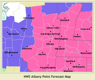 Question for Jason, Suds, Noreaster27 or those who know: Is this turn of events because the coastal development was closer to the shore, or because the initial low hung in there longer? And a related question... when exactly is 0Z Weds - is it 5am Eastern Time? 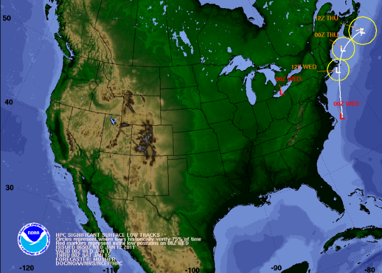 One thing about storms that start too far east and then seem to track more westward - no precip type issues. And one more question for Raymo ... when are your days off?
"You just need to go at that shit wide open, hang on, and own it." —Camp
|
|
0z wed is tues night at 7pm
the surface low was never a real beast,, but the upper low was..that caused most of the snow initially..also the low is right in the box (40n 70w) classic set up for north east storm...for gore and the adk's to really hook up the low needs to cut through NYC..still it was nice event !!!!
"Peace and Love"
|
«
Return to Weather Archive
|
1 view|%1 views

