Storm Speculation: 1/8/11

classic Classic list List threaded Threaded
18 messages Options
Reply | Threaded
Open this post in threaded view
|

Storm Speculation: 1/8/11

Harvey
Administrator
This post was updated on .
NATIONAL WEATHER SERVICE ALBANY NY
745 AM EST SUN JAN 2 2011

LONG TERM - WEDNESDAY THROUGH SATURDAY

AS HAS BEEN THE CASE MUCH OF THIS WINTER...A LARGE UPPER LEVEL VORTEX WILL SET UP ACROSS EASTERN CANADA. THIS WILL RESULT IN A WEST TO NORTHWEST CYCLONIC FLOW AT MID AND UPPER LEVELS ACROSS THE FORECAST AREA FOR THE ENTIRE LONG TERM PERIOD. SHORTWAVE TROFS WILL BE EMBEDDED WITHIN THE OVERALL CYCLONIC FLOW PATTERN...RESULTING IN A FORECAST WITH SNOW OR SNOW SHOWERS BEING FORECAST MUCH OF THE TIME.

ALTHOUGH MOST OF THE TIME THESE FEATURES AND ANY SNOWFALL THEY PRODUCE WILL NOT BE SIGNIFICANT...THE GFS/ECMWF/CANADIAN/ENSEMBLE MEMBERS ARE NOW INDICATING THE POSSIBILITY THAT A SIGNIFICANT SURFACE WAVE MAY DEVELOP AS IT COMES AROUND THE BASE OF THE CYCLONIC VORTEX...AND EMERGES OFF THE MID ATLANTIC COAST SOMETIME BETWEEN THURSDAY NIGHT AND FRIDAY NIGHT.

FOR THIS PERIOD HAVE FORECAST HIGHER POPS...IN THE 40 TO 50 PERCENT RANGE AND FORECAST SNOW RATHER
THAN SNOW SHOWERS. AS WITH THE LAST MAJOR EVENT...LOTS OF UNCERTAINTY IN THE ENSEMBLE MEMBERS WITH THE POSSIBILITIES RANGING FROM LITTLE OR NO SNOW...TO WELL OVER AN INCH OF LIQUID EQUIVALENT.

"You just need to go at that shit wide open, hang on, and own it." —Camp
Reply | Threaded
Open this post in threaded view
|

Re: Storm Speculation: 1/7/11

JasonWx
once again the models are all over the place on this one..
the euro shows just a weak cold front and system. at least it gets cold...
"Peace and Love"
Reply | Threaded
Open this post in threaded view
|

Re: Storm Speculation: 1/7/11

sudsnbumps
I am sticking with my post over on the weather thread and agree with the Euro that it could be a clipper type system.  Moisture starved but cold enough to pull out a few inches.  This week will be cold enough for snowmaking to recover and if the LE lines up right several inches total by the end of the week...speaking of which, there is a long term possibility for late next weekend per the GFS.  Right now they have it coming close but just not close enough...only time will tell...it is a new year.  I did enjoy spring skiing yesterday with no rain
Proud to call Gore My Home Mountain
Covid stole what would have been my longest season ever!
I'll be back
Reply | Threaded
Open this post in threaded view
|

Re: Storm Speculation: 1/7/11

adkskier
In reply to this post by Harvey
A major Adirondack dusting
I Think, Therefore I Ski
Reply | Threaded
Open this post in threaded view
|

Re: Storm Speculation: 1/7/11

zach
Reply | Threaded
Open this post in threaded view
|

Re: Storm Speculation: 1/7/11

Harvey
Administrator
NATIONAL WEATHER SERVICE ALBANY NY
414 PM EST MON JAN 3 2011

LONG TERM /THURSDAY THROUGH MONDAY/...

RATHER ACTIVE LONG TERM FORECAST REMAINS AS A SERIES OF SHORT WAVES WILL CARVE OUT AN EAST COAST TROUGH WITH THE CENTER OF THE UPPER LOW SITUATED OVER THE GREAT LAKES.

A POTENT PACIFIC JET CONTINUES TO TRACK INLAND ACROSS THE CONUS WITH A LEAD SHORT WAVE COMBINING WITH THE CONTRIBUTIONS FROM THE GREAT LAKES FOR A CHANCE OF LIGHT SNOW THROUGH THURSDAY ...ONLY LIGHT AMOUNTS OF QPF ARE EXPECTED.

AS THIS PACIFIC JET DIVES SOUTHEAST TOWARD THE OHIO RIVER VALLEY THURSDAY NIGHT...THE UPPER LOW WILL BECOME BETTER DEFINED OVER THE GREAT LAKES WITH AN EAST COAST TROUGH EVOLVING.  

FROM HERE...MODELS DIVERGE WITH RESPECT TO QPF AND SURFACE LOW PLACEMENT....

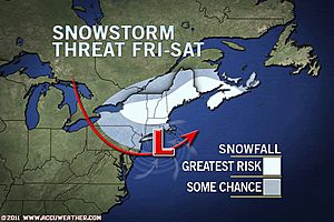
AT THIS TIME IT SEEMS THE REGION IS POISED FOR A PROLONGED SNOW EVENT AS A DEFORMATION/TROWAL AXIS WILL BE IN THE VICINITY. TIMING AND STRENGTH OF THE SHORT WAVE COULD ALLOW FOR THIS TROUGH TO BECOME NEGATIVELY TILTED WITH A DEEPENING SURFACE COASTAL LOW NEAR NEW ENGLAND.  

500MB ENSEMBLES FROM THE GFS SHOW HIGH CONFIDENCE THAT THIS UPPER LOW WILL BE OVER THE EASTERN GREAT LAKES.  HOWEVER...THE SAME CAN NOT BE SAID FOR ITS SURFACE REFLECTION WITH A RATHER LARGE SPREAD IN THE TRACKS AND INTENSITY with HIGH STANDARD DEVIATIONS.  SO THE TIME FRAME OF INTEREST WILL BE BETWEEN FRIDAY AND SATURDAY.  MAYBE AS EARLY AS THURSDAY NIGHT.

GIVEN THE TRENDS FROM THE PAST SEVERAL DAYS OF ANOTHER ACCUMULATING SNOWFALL EVENT...WE WILL HIGHLIGHT THE POTENTIAL FOR SNOW IN THE HWO AT THIS TIME.

EDIT to added Accuweather map:

"You just need to go at that shit wide open, hang on, and own it." —Camp
Reply | Threaded
Open this post in threaded view
|

Re: Storm Speculation: 1/7/11

sudsnbumps
In reply to this post by zach
If only...however until then the Lake effect plume is headed in the right direction for at least another day
Proud to call Gore My Home Mountain
Covid stole what would have been my longest season ever!
I'll be back
Reply | Threaded
Open this post in threaded view
|

Re: Storm Speculation: 1/8/11

Snowballs
Banned User
This post was updated on .
In reply to this post by Harvey
Steve Caporizzo News 10 Albany Weather is now saying, thru Saturday 7 pm, 6-10 inches for the Gore region. His map shows Gore right on the edge of the " up to 14 inches ". It's suppose to start around 8 am Friday.

They better be right. If not, I'm thinking about peeing in their rain gauge.
Reply | Threaded
Open this post in threaded view
|

Re: Storm Speculation: 1/8/11

Snowballs
Banned User
OH! They just said it will be that " Dry, powdery snow "!!!!

Don't hose us Cap or I'll return the favor.
Reply | Threaded
Open this post in threaded view
|

Re: Storm Speculation: 1/8/11

sudsnbumps
Damn all of the models are showing a bullseye pretty close to Gore.  I think the consensus is a little west but we'll take whatever we can get.  I am going to predict (guess) a couple inches tomorrow (65 under foot GS) 10 inches by green light Saturday (70mm)  15-18" by sunday AM but snowing and blowing all day saturday.  
Proud to call Gore My Home Mountain
Covid stole what would have been my longest season ever!
I'll be back
Reply | Threaded
Open this post in threaded view
|

Re: Storm Speculation: 1/8/11

Adk Jeff
Harv, what happened to the "Mega Harv" snow totals?
What are the numbers for this year?
Reply | Threaded
Open this post in threaded view
|

Re: Storm Speculation: 1/8/11

tBatt
Adk Jeff wrote
Harv, what happened to the "Mega Harv" snow totals?
What are the numbers for this year?
I was wondering the same. How much are they claiming on their website? I doubt they have gotten anything over 18" natural this year.
Reply | Threaded
Open this post in threaded view
|

Re: Storm Speculation: 1/8/11

Harvey
Administrator
For those who aren't aware, the MegaHarv Snow Totals is our attempt to try to keep track of seasonal snowfall for Northern Warren County.  It's a vestige from the past when Harvey Road's focus was more exclusively about Gore Mountain.  It's actually not an easy thing to do because of the way numbers are updated, but I decided to try to keep up with it again this year. It was named for a great Skiadk poster named Megatron who actually had the original idea to keep the total.

MegaHarv 2010/2011 has 16" recorded.  I think this number is higher that Gore's season total would show.  We got two inches at HQ from the Nor'easter last week, measured on our porch which is wind sheltered.  Gore did not record any snow from that event, but I saw evidence at Gore that the totals were the same over there. Plus we count all snow that falls regardless of whether or not lifts are running.  I like to look back at the MHST and see what happened that year. If it snowed a foot in October and then melted, we'll record it.

Funny thing about this thread is that I started it when, early in the week models were indicating the possibility of a coastal event.  Jason "First Week in January" Thread probably made more sense, as he (correctly) saw no relevant coast storm. Be interesting to see if actually hit WS Warning criteria.  (7 inches in 12 hours or 9 inches in 24 hours).

I'm guessing we will, but many smart mets are in disagreement.

Winter Storm Warning in pink, Winter Storm Watch in purple:

"You just need to go at that shit wide open, hang on, and own it." —Camp
Reply | Threaded
Open this post in threaded view
|

Re: Storm Speculation: 1/8/11

Jamesdeluxe
Harvey44 wrote
MegaHarv Snow Totals is our attempt to try to keep track of seasonal snowfall for Northern Warren County (...) we count all snow that falls regardless of whether or not lifts are running.
I always thought that MegaHarv was an attempt to provide a YTD and annual snowfall figure for Gore, similar to the ones that all other ski areas publish, rather than Warren County in general. But the fact that you count all snow, including that which doesn't contribute to the base at the opening of the season, makes me think otherwise.

Doesn't Gore post a daily snowfall figure on its website, and couldn't you just keep track of them?

I'm sure that this has been discussed to death in the past, but I wasn't paying attention.
Reply | Threaded
Open this post in threaded view
|

Re: Storm Speculation: 1/8/11

Harvey
Administrator
In North River: Looks like about six inches on the porch since last Sunday. Radar doesn't show it but it's still snowing. Maybe a half inch in the last hour. Totals seem elevation dependent. Much more at 2000 vs 1000 ft. It's total pixie dust.

Jason's call looks pretty darn good. Any chance for more in the next 24 hours?
"You just need to go at that shit wide open, hang on, and own it." —Camp
Reply | Threaded
Open this post in threaded view
|

Re: Storm Speculation: 1/8/11

Harvey
Administrator
Never seen such consistent lightly falling snow add up.  

Looks like another 3+ inches since midnight.

I'll try for some photo evidence at daybreak.
"You just need to go at that shit wide open, hang on, and own it." —Camp
Reply | Threaded
Open this post in threaded view
|

Re: Storm Speculation: 1/8/11

Sick Bird Rider
Harvey44 wrote
I'll try for some photo evidence at daybreak.
Posting at 3:53 am? Do you ever sleep?
Love Jay Peak? Hate Jay Peak? You might enjoy this: The Real Jay Peak Snow Report
Reply | Threaded
Open this post in threaded view
|

Re: Storm Speculation: 1/8/11

Snowballs
Banned User
Hehehe. I figured his Harvness wouldn't be able to sleep last night, even posted such on the blog last night. The new snowfall musta kept him up.


Unless, He and Z were awake and placing an order for  more neve.

People get friskie in the hills.