Storm Speculation: 12/26/10
12
12
|
Administrator
|
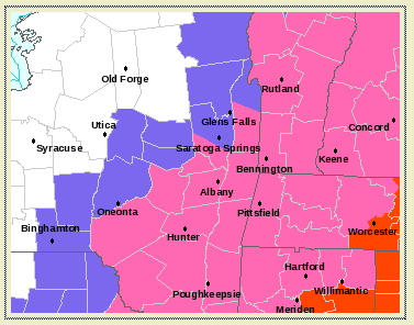
WInter Storm Watch has been extended to include Albany and points as far north as Clifton Park.
Here, kitty kitty kitty.... URGENT - WINTER WEATHER MESSAGE NATIONAL WEATHER SERVICE ALBANY NY 1158 AM EST SAT DEC 25 2010 SCHOHARIE-WESTERN SCHENECTADY-EASTERN SCHENECTADY-SOUTHERN SARATOGA-WESTERN ALBANY-EASTERN ALBANY WESTERN RENSSELAER-EASTERN RENSSELAER-BENNINGTON-WESTERN WINDHAM- EASTERN WINDHAM- ...WINTER STORM WATCH IN EFFECT FROM SUNDAY AFTERNOON THROUGH MONDAY MORNING... THE NATIONAL WEATHER SERVICE IN ALBANY HAS ISSUED A WINTER STORM WATCH...WHICH IS IN EFFECT FROM SUNDAY AFTERNOON THROUGH MONDAY MORNING. * LOCATIONS: SCHOHARIE COUNTY...CAPITAL REGION OF NEW YORK...RENSSELAER COUNTY AND ALL OF SOUTHERN VERMONT. * HAZARDS: MODERATE TO HEAVY SNOW...AND GUSTY WINDS. * ACCUMULATIONS: 7 OR MORE INCHES OF SNOW WILL BE POSSIBLE. * TIMING: LIGHT SNOW MOVES IN SUNDAY AFTERNOON...TRANSITIONING TO MODERATE TO HEAVY SNOW SUNDAY NIGHT THROUGH MONDAY MORNING. * IMPACTS: HAZARDOUS TRAVEL DUE TO SIGNIFICANT ACCUMULATIONS OF SNOW ON ROADS. VISIBILITIES WILL BE REDUCED IN THE SNOW. STRONG WINDS WILL MAKE DRIVING TREACHEROUS DUE TO BLOWING AND DRIFTING SNOW. * WINDS: NORTH TO NORTHEAST WINDS AT 10 TO 20 MPH WITH GUSTS TO AROUND 35 MPH SUNDAY NIGHT THROUGH MONDAY MORNING.
"You just need to go at that shit wide open, hang on, and own it." —Camp
|
|
Lift your glass of deep red wine and join me in the Sacrifice to Ullr.
From afar, we honor you, oh great Ullr. Hear as we hail you Offerings we pour to you In honor and love (Sound the hunting horn) Hail to Ullr Join with us on this dark night to feast in the glory of Winter. With the stroke of your mighty hand, Cover the fields and the mountains Receive our sacrifice. Think that will work, Jason? You try your method, I'll try mine. BTW, I tried to find a Virgin to sacrifice. Nothing in Saratoga or Warren Counties. Sorry. Keep looking.
If you are having fun, you are doing it right.
|
|
Administrator
|
Yea we had some fun with the whole virgin thing.
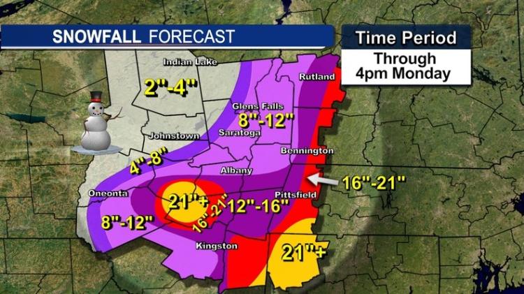
The advantage that we have over Jason ... we are not tied to the facts or scientific evidence in any way. Keep an eye the 48 and 96 hour snowfall forecasts, and the NWS Albany Point Forecast map for (hopefully) a northward extension of the winter storm watch: http://www.nyskiblog.com/p/ny-weather.html Next model runs should be out in a couple hours, and Jason will be back from Belleayre. Stay tuned.
"You just need to go at that shit wide open, hang on, and own it." —Camp
|
|
This post was updated on .
Apparently Jason has the best of it...He's skiing! I am wearing shorts in 70 degree weather
 I think the sacrifices are working. It looks like the storm is going to get closer to the coast and Gore will get something. A few inches would be nice and if this thing bombs out and comes in a hundred miles or so, maybe more than that. Should be fun hitting it after 18 hours of driving. On another note, the GFS is trying to bring in colder air for New Years and the snow word has crept into the forecast with that four letter R word. It is still looking warm but more of that deep red sacrifice is in order...Merry Christmas Ullr! Latest update: I want to cry, near misses are like losing a close game (Giant's fans understand this) I am holding on to one hope...there is a storm discussion on FIS and I love this quote: "Gulf origin lows are nuts. They do crazy stuff" I am down here just south of the energy coming together. We have big wind and heavy rain just north of us....please, please, please track 100 miles to the west of the currently forecasted track...I really want to ski pow at Gore on Tuesday
Proud to call Gore My Home Mountain
Covid stole what would have been my longest season ever! I'll be back |
|
2 inch of qpf up to ALB..just insane
more later going out for Chinese food..a jewish thing
"Peace and Love"
|
|
well it looks like the big winners will be the Cats..As of now , it's a pretty safe bet they will get around 12"+..
the Greens and White should pick up 12+ too..But the main problem with this system will be the WIND..Gusts over 50 in the mountains will be common.. I'm sure there will be more to say tomorrow..
"Peace and Love"
|
|
Administrator
|
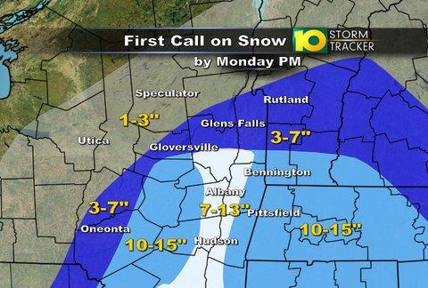
Channel 10's map...
 Maybe enough for Hickory to get going?
"You just need to go at that shit wide open, hang on, and own it." —Camp
|
|
Steve and his crew are the best in the capital region but I so hope they are off by a few miles There is some insane energy down here http://radar.weather.gov/Conus/southeast_loop.php
Proud to call Gore My Home Mountain
Covid stole what would have been my longest season ever! I'll be back |
|
Administrator
|
Had a hard time sleeping.
Looks real for almost everyone except maybe the Adks...  Adks are going to need some magic ... ...so CLOSE for Whiteface and Gore, with the edge the Winter Storm Warning Area at Glens Falls and the VT border.
"You just need to go at that shit wide open, hang on, and own it." —Camp
|
|
Administrator
|

"You just need to go at that shit wide open, hang on, and own it." —Camp
|
|
Plattekill alert
|
|
My Quebec trip looks like it will be delay by a day because of the storm and bad Chinese food..General 1-2 ft snowfall through out the region looks reasonable..Yes Harv you too..Maybe not 2' , but you should have some fresh to play in..
"Peace and Love"
|
|
7:35 pm No snow yet in Ballston Spa.
|
|
Maybe 2 inches here in Lake George area. Wind is just cranking!
|
|
17 inches in Northern Bergen County NJ...Campgaw would have been a powder paradise at 299 vertical feet but we delayed our trip north and didn't get there until 2pm...no skiing today

Proud to call Gore My Home Mountain
Covid stole what would have been my longest season ever! I'll be back |
|
Not a flake...not even a dusting here in Johnsburg (aka North Creek). Lot of wind all day. Gore reported wind holds on 3 lifts.
I Think, Therefore I Ski
|
|
Administrator
|
I'd say we got an inch or two in North River. Somehow it's snowing now above 1500 feet. And the stars are out.
According to Brent (AlbanyWxExaminer) a town in Bergen County checked in with 32 inches. That was the highest total I saw. I went out last night at the height of the storm and it was pretty incredible. One thing I've learned in Nor'easters ... if we don't get any mixed precip in downtown flatlands ... the Adks are too far west. Man the wind is really rippin. Kinda scary.
"You just need to go at that shit wide open, hang on, and own it." —Camp
|
|
I don't know how anyone down there could get an accurate count...the wind was incredible. My mom (Ramsey, NJ) said they had already plowed her out and when we showed up at 2 there was a wind drift probably 6 feet high. Along I-95 there was snow from South Carolina all the way up. a lot in North Carolina, very little around DC and tons in NJ Cars were burried everywhere on the highway. I am interested to find out where the best skiing was today, taking into consideration the wind and the snow...I am guessing I will need my best edges tomorrow at Gore?
Proud to call Gore My Home Mountain
Covid stole what would have been my longest season ever! I'll be back |
|
Administrator
|
I don't know how they could blow snow or groom right now. Any hardpack that you turned in machine groomed would disappear. This is pretty cool time-lapse photo from the nor'easter in the flatlands. Not sure how many inches it records, but it's a lot. It's VIMEO so let it fully load before playing it: December 2010 Blizzard Timelapse from Michael Black on Vimeo.
"You just need to go at that shit wide open, hang on, and own it." —Camp
|
«
Return to Weather Archive
|
1 view|%1 views

