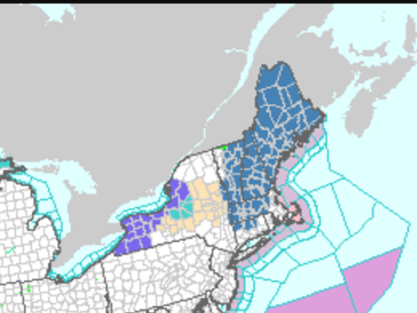
Thanks man. Here in Johnsburg it looks like we are on the border between a small amount and a nice amount.

NWS ALY:
Snow is expected to quickly develop from NW to NE across the area
Thursday morning into early afternoon with an initial surge of
isentropic lift and southerly flow aloft. Then, as the cyclone
rapidly intensifies along the New England coast late Thursday into
Thursday night, mesoscale banding appears likely along the west side
of the storm where strong frontogenesis is forecast to occur. Could
be a setup for a strong and potentially large band based on CSTAR
research. The location of this possible band of 2"+ per hour snowfall
rates is still in question this far out though. There are still some
model discrepancies, with the ECMWF and the NAM most aggressive with
heavy QPF from banding making into the north/central Taconics and
western New England. For this reason, a Winter Storm Watch has been
issued for Washington county, northern and central Taconics, all of
southern Vermont, the Berkshires and northern Litchfield counties.
A few to several inches of snow will be possible farther west, but
areas in the watch have a higher confidence for 6-12 inches of snow
with perhaps more if mesoscale banding sets up in this area. There
is still some guidance (GFS/CMC) showing the best F-Gen and banding
farther eastward into New England. Additional Winter Storm Watches
or eventually Advisories will likely be needed later in time for
the rest of the area as confidence increases, so will continue to
mention this potential in the HWO.
"You just need to go at that shit wide open, hang on, and own it." —Camp