Storm Speculation: 3/3/14

classic Classic list List threaded Threaded
20 messages Options
Reply | Threaded
Open this post in threaded view
|

Storm Speculation: 3/3/14

ScottyJack
This post was updated on .
Something coming or what??
I ride with Crazy Horse!
Reply | Threaded
Open this post in threaded view
|

Re: Storm Specs 3-3-14

JasonWx
to early to tell...as of now it looks like a southern event..
"Peace and Love"
Reply | Threaded
Open this post in threaded view
|

Re: Storm Specs 3-3-14

Face4Me
JasonWx wrote
to early to tell...as of now it looks like a southern event..
Of course it is ...

It's easy to be against something ... It's hard to be for something!
Reply | Threaded
Open this post in threaded view
|

Re: Storm Specs 3-3-14

NorEaster27
Looks like another NYC storm but its still early.
Reply | Threaded
Open this post in threaded view
|

Re: Storm Specs 3-3-14

ScottyJack
This is bullshit!
I ride with Crazy Horse!
CMR
Reply | Threaded
Open this post in threaded view
|

Re: Storm Specs 3-3-14

CMR
Agreed.  Another storm to screw up life here in Downstate without any Adirondack benefit.  We are heading toward a record year in the NYC area.  Only another foot or so to best 1996.
Reply | Threaded
Open this post in threaded view
|

Re: Storm Specs 3-3-14

snoloco
There is plenty of benefit downstate.  Creek is getting snow and they have announced that they will stay open till April because of all the great natural they've got.  I don't mind having to shovel out, it is still 1 trillion times better than r*in.
I've lived in New York my entire life.
Reply | Threaded
Open this post in threaded view
|

Re: Storm Specs 3-3-14

JasonWx
In reply to this post by ScottyJack
ScottyJack wrote
This is bullshit!
as a weather nut and downstate resident. if monday's event pans out , this might be the best winter in my 51yrs..
yes better than the 77/78 winter..

i bet Platt and the rest of the Cat's areas have smiles on their faces and money in their checkbooks..
"Peace and Love"
Reply | Threaded
Open this post in threaded view
|

Re: Storm Specs 3-3-14

snoloco
JasonWx wrote
i bet Platt and the rest of the Cat's areas have smiles on their faces and money in their checkbooks..
I'm sure they do.  When the snow falls where the money and people are, the money ends up in their pockets when people come to the mountain.
I've lived in New York my entire life.
Reply | Threaded
Open this post in threaded view
|

Re: Storm Specs 3-3-14

ml242
I am finally going to hit some lines in the Catskills I've had my eye on for years this spring, can't wait*.


*fingers crossed, knock and wood, and the rest.
Reply | Threaded
Open this post in threaded view
|

Re: Storm Specs 3-3-14

Harvey
Administrator
Moving a little north on the track?

Snow Storm
"You just need to go at that shit wide open, hang on, and own it." —Camp
Reply | Threaded
Open this post in threaded view
|

Re: Storm Specs 3-3-14

JasonWx
not really
"Peace and Love"
Reply | Threaded
Open this post in threaded view
|

Re: Storm Specs 3-3-14

NorEaster27
Still looks like a Phil to NYC storm to me.  PV is too strong and too far south for this storm to make it further north.
Reply | Threaded
Open this post in threaded view
|

Re: Storm Specs 3-3-14

JasonWx
If the BC zone moves north so will the precipt...time will tell..
"Peace and Love"
Reply | Threaded
Open this post in threaded view
|

Re: Storm Specs 3-3-14

Harvey
Administrator
NWS ALY:

SUNDAY NIGHT AND MONDAY...

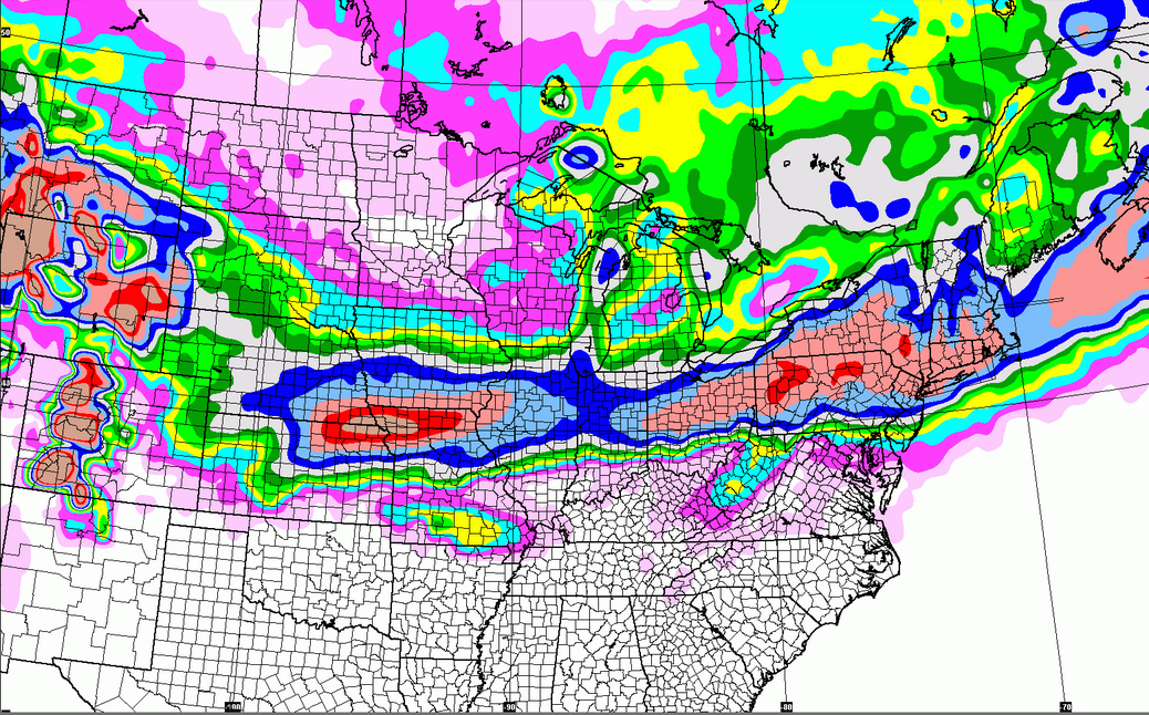
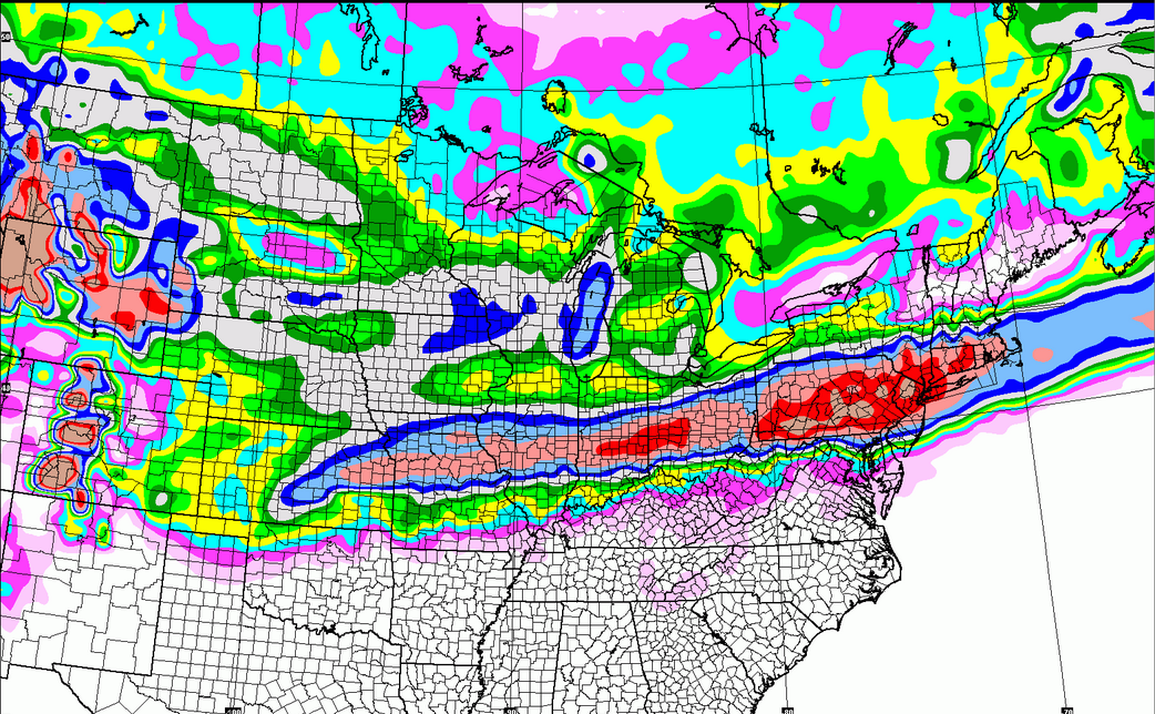
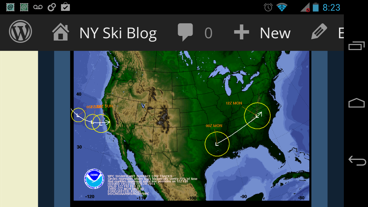
A SIGNIFICANT WINTER STORM IS POSSIBLE AND HAVE POPS INCREASING THROUGH THE PERIOD TO LIKELY ACROSS MUCH OF THE AREA BY MONDAY. THE MODELS ARE GENERALLY IN GOOD AGREEMENT THAT THE SOUTHERN HALF OF THE FA WILL HAVE SIGNIFICANT SNOWFALL...BUT THERE IS LESS AGREEMENT ACROSS THE NORTHERN HALF OF THE FA WITH THE GGEM HAVING THE LEAST AMOUNT OF MOISTURE ACROSS NRN AREAS.

THE GEFS PLUME DIAGRAM HAS A GREAT DISCREPANCY IN TERMS OF PCPN AMOUNTS FOR KALB WITH AS LITTLE AS A TENTH OF AN INCH OF QPF UP TO 1.72 INCHES OF QPF WITH A MEAN OF 0.61 INCH. GFS HAS IMPRESSIVE FGEN ACROSS SE THIRD OF FA AT 18Z MON. FOR NOW WILL GO CATEGORICAL POPS ON MONDAY ACROSS THE FAR SOUTHEAST PORTION OF FA WITH LIKELY POPS UP THROUGH THE MOHAWK VALLEY...SARATOGA REGION AND SOUTHERN VERMONT AND THEN CHANCE POPS FARTHER NORTH. EXPECT LOWS SUNDAY NIGHT TO BE IN THE SINGLE DIGITS AND TEENS WITH HIGHS ON MONDAY IN THE MID TEENS TO MID 20S.
"You just need to go at that shit wide open, hang on, and own it." —Camp
Reply | Threaded
Open this post in threaded view
|

Re: Storm Specs 3-3-14

ml242


I'm not in this camp but still like the comic.
Reply | Threaded
Open this post in threaded view
|

Re: Storm Specs 3-3-14

scottymac
In reply to this post by Harvey
Harvey, Im a novice with the weather maps. Can you explain what "FA" stands for?
Thanks
Reply | Threaded
Open this post in threaded view
|

Re: Storm Specs 3-3-14

Harvey
Administrator
scottymac wrote
Harvey, Im a novice with the weather maps. Can you explain what "FA" stands for?
Thanks
I believe "FA" is NWS shorthand for "forecast area."

I does look like the GFS is pushing the storm south now.


Rooting for a Powder Daize at Plattekill!
"You just need to go at that shit wide open, hang on, and own it." —Camp
Reply | Threaded
Open this post in threaded view
|

Re: Storm Specs 3-3-14

Harvey
Administrator

That's a southern stormtrack
"You just need to go at that shit wide open, hang on, and own it." —Camp
Reply | Threaded
Open this post in threaded view
|

Re: Storm Specs 3-3-14

Danzilla
Holy cow this thing has gone south. It doesn't look like NYC is even going to get much. DC looks like they are gonna get a direct hit.