Tour of Hudson Flooding
Reply |
Threaded

Open this post in threaded view
|
More ♦
♦
| Loading... |
| Reply to author |
| Edit post |
| Move post |
| Delete this post |
| Delete this post and replies |
| Change post date |
| Print post |
| Permalink |
| Raw mail |
       |
Tour of Hudson Flooding
|
This post was updated on May 02, 2011; 1:46pm.
Not sure if this qualifies as a TR, but...
I am sorry for the people who suffered from the flooding. This video is only to document my ride through an historic flood on the upper Hudson River.
|
Reply |
Threaded

Open this post in threaded view
|
More ♦
♦
| Loading... |
| Reply to author |
| Edit post |
| Move post |
| Delete this post |
| Delete this post and replies |
| Change post date |
| Print post |
| Permalink |
| Raw mail |
       |
Re: Tour of Hudson Flooding
|
WOW, that is pretty ridiculous. As soon as I saw the first shot I was waiting for one of Hopewell to come up. I've seen it high, but NEVER that high.
Good thing it's not summer, because I'm sure some idiot would jump it. If I had a whitewater raft though...  . The last time I saw it up real high, we were driving through and thinking about jumping. Even off the small rock into the eddy was sketchy, so we stayed away. The next day we heard that a Navy guy from the Knolls power plant had drown there - Just swimming across, not even jumping. Turns out he was my next door neighbor. I didn't know him because new guys are there every six months. We haven't jumped since. . The last time I saw it up real high, we were driving through and thinking about jumping. Even off the small rock into the eddy was sketchy, so we stayed away. The next day we heard that a Navy guy from the Knolls power plant had drown there - Just swimming across, not even jumping. Turns out he was my next door neighbor. I didn't know him because new guys are there every six months. We haven't jumped since.
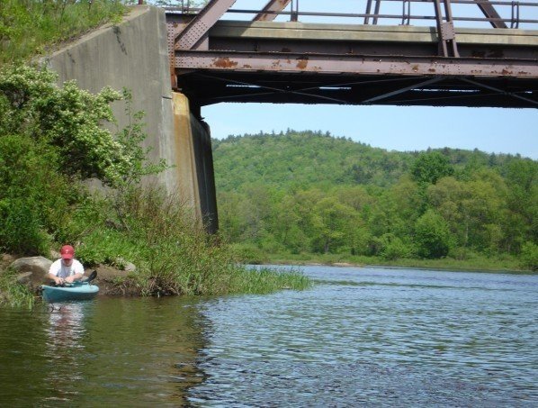
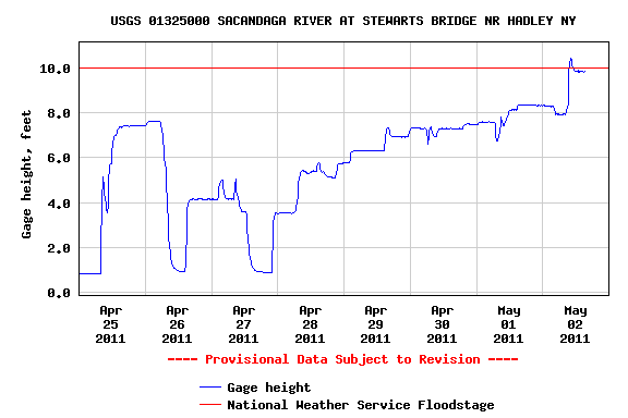
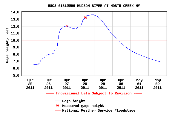
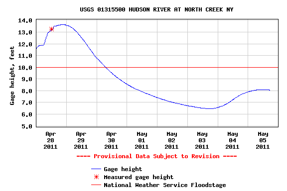
The Thurman bridge must have been within a few feet of the deck. That's pretty ridiculous. For comparison, here it is at normal level.  Here are some of the local gauges. Sacandaga river, which comes out just below Hopewell.  North Creek  Looks like we have another 2-3 inches on the way. This is pretty absurd stuff. I wonder if it's all snow on Tuckerman  I finally have a whitewater kayak setup to use this summer. I think I should get a drytop! Or maybe some skills first.  |
Reply |
Threaded

Open this post in threaded view
|
More ♦
♦
| Loading... |
| Reply to author |
| Edit post |
| Move post |
| Delete this post |
| Delete this post and replies |
| Change post date |
| Print post |
| Permalink |
| Raw mail |
       |
Re: Tour of Hudson Flooding
|
I shared this with my kayaking friends and we agree there's really a viable line right down the middle. When the water drops, this could potentially become more dangerous because who knows what kind of hydraulics could form under the falls. At this level, it's just a big flush, brace and roll your way through. There were some frightening looking boils just downstream of the bridge. This is a very deep spot in the river; if you had the misfortune to end up in these boils and come out of your boat (it's much harder to roll in that stuff), you could go very deep for a long time in a seam.
It would be very interesting to see the Narrows in the Gorge at this level, but I suspect a lot was just washed out and you would just have 10 - 15 foot standing waves...maybe bigger. |
Reply |
Threaded

Open this post in threaded view
|
More ♦
♦
| Loading... |
| Reply to author |
| Edit post |
| Move post |
| Delete this post |
| Delete this post and replies |
| Change post date |
| Print post |
| Permalink |
| Raw mail |
       |
Re: Tour of Hudson Flooding
|
Banned User
|
That's my impression also, from past incidents. Even at lower water levels, calm water, that stretch below the falls just literally sucks swimmers under and holds them under, sometimes for days or longer. People who drown there, quickly disappear completely even when the water is calm, then resurface days later in the same general area. Always thought like Mike said, it's probably deep there. Maybe the falls/river has cut/ is cutting subterrean passages and water flows down below the river bed as it makes it's way down the " cataracts ", out of the Mtns, to the piedmont, so to speak. |
Reply |
Threaded

Open this post in threaded view
|
More ♦
♦
| Loading... |
| Reply to author |
| Edit post |
| Move post |
| Delete this post |
| Delete this post and replies |
| Change post date |
| Print post |
| Permalink |
| Raw mail |
       |
Re: Tour of Hudson Flooding
|
The river is insanely powerful there. One time I was jumping under the bridge and I saw some kids slide down the falls in the water - I'm surprised they came out alive.
A good friend of mine jumps there all the time. He said he has been pulled under before and barely made it out. I'm pretty dumbfounded why he STILL jumps there. If you get sucked down, you're not coming up for a while. Chances are you won't be alive anymore, either. Tons of underwater caves from what I've heard. Not to mention rumors of a school bus, excavation equipment, and an old bridge. I'm sure there are some experienced paddlers around who could run it. I know someone who has done it before, he said they would throw big foam blocks down the falls and depending on where it would come up is how the decide whether to run it or not. I doubt he has ever been there when it is this big before, though. Actually, he lives a few blocks away from you (from what I could tell in your POV test cam anyways). Do you know Johnny Miller? He used to do some promotional stuff for Gore a while back. He's the one who got me started with paddling actually. He used to own the Kayak shop that was next to the old YMCA, and he runs clinics in the pool in the spring. I heard the water is HUGE up in the narrows now. ARO lost two boats last weekend. Do you do any whitewater yourself? I did the clinics at the Y and have a pretty strong roll and decent bracing. Never had to roll in whitewater though. I've only actually ran a river once, the Sacandaga last summer. |
Reply |
Threaded

Open this post in threaded view
|
More ♦
♦
| Loading... |
| Reply to author |
| Edit post |
| Move post |
| Delete this post |
| Delete this post and replies |
| Change post date |
| Print post |
| Permalink |
| Raw mail |
       |
Re: Tour of Hudson Flooding
|
This post was updated on May 05, 2011; 1:27am.
I bought my last WW kayak from his shop, but I really don't know John personally. Yes, I started WW kayaking in 1987. When I was younger, single, and most of my boating friends single, we'd boat every weekend, wherever the water was. I've boated every major river between Georgia and Quebec, as well as the big rivers in CO and the Grand Canyon. I've also seen a friend drown doing a stupid thing (running a low head dam at high water) 4 miles from my home. There were no dangerous holes in that big water, so if you flip, just try to roll, and if you can't, stay in your boat until things calm down. Everything in the main flow was being flushed downstream fast. Your boat knows a lot more about floating than any swimmer. You should take a clinic from the local outfitters or elsewhere or join a club that does development for beginners. I was fortunate to have the KCCNY near me when I was getting started. I hope to boat the Hudson Gorge in a week or two after the rain stops. If you're adventurous, go to the Ottawa this summer. Warm water, and huge drops that won't kill you. There are some good clinics there too. |
Reply |
Threaded

Open this post in threaded view
|
More ♦
♦
| Loading... |
| Reply to author |
| Edit post |
| Move post |
| Delete this post |
| Delete this post and replies |
| Change post date |
| Print post |
| Permalink |
| Raw mail |
       |
Re: Tour of Hudson Flooding
|
Banned User
|
My paddle adventures involve the canoe and trolling motor.
|
Reply |
Threaded

Open this post in threaded view
|
More ♦
♦
| Loading... |
| Reply to author |
| Edit post |
| Move post |
| Delete this post |
| Delete this post and replies |
| Change post date |
| Print post |
| Permalink |
| Raw mail |
       |
Re: Tour of Hudson Flooding
|
Anybody up there with flooding updates?
|
Reply |
Threaded

Open this post in threaded view
|
More ♦
♦
| Loading... |
| Reply to author |
| Edit post |
| Move post |
| Delete this post |
| Delete this post and replies |
| Change post date |
| Print post |
| Permalink |
| Raw mail |
       |
Re: Tour of Hudson Flooding
|
Haven't been there personally, but levels are dropping significantly.

|
Reply |
Threaded

Open this post in threaded view
|
More ♦
♦
| Loading... |
| Reply to author |
| Edit post |
| Move post |
| Delete this post |
| Delete this post and replies |
| Change post date |
| Print post |
| Permalink |
| Raw mail |
       |
Re: Tour of Hudson Flooding
|
In reply to this post by tBatt
I've jumped from the top of the bridge before...It's a long way and a pretty cool drop. I was there with friends one time jumping into the falls with inner tubes and riding out the rapids when this guy came up to us and talked us into jumping in without the tubes...young dumb and drunk...we all lived but the undertow was incredible...having swam in the ocean most of my life, you learn to somewhat ride it out and hope you surface but we had to grab one of our friends who had given up and almost drowned...needless to say I never did that again. You have two powerful rivers coming together there and the currents underneath are crazy. I was calling on a customer last week who said he had a work crew in Hadley that reported the water was up to the bottom of the bridge...I searched YouTube and saw some pics but nothing that close. Personally, the Kaydeross in Ballston Spa/Saratoga looks like it is going to be perfect on Saturday (actually Friday will be the best but I have to work)...that's my speed
Proud to call Gore My Home Mountain
Covid stole what would have been my longest season ever! I'll be back |
Reply |
Threaded

Open this post in threaded view
|
More ♦
♦
| Loading... |
| Reply to author |
| Edit post |
| Move post |
| Delete this post |
| Delete this post and replies |
| Change post date |
| Print post |
| Permalink |
| Raw mail |
       |
Re: Tour of Hudson Flooding
|
Administrator
|
NWS still hasn't updated their historical records to include last week's flood.
The river at North Creek crested at 13.55 feet (I think). It's amazing when you look at that number in context. These are the previous top 25 measurements of flood stage at North Creek dating back to 1913 - almost 100 years: (1) 12.14 ft on 12/31/1948 (2) 12.10 ft on 03/19/1936 (3) 11.70 ft on 03/27/1913 (4) 11.54 ft on 01/09/1998 (5) 11.37 ft on 06/03/1947 (6) 11.30 ft on 04/28/1979 (7) 10.70 ft on 10/07/1932 (8) 10.63 ft on 05/03/1972 (9) 10.54 ft on 04/01/1976 (10) 10.27 ft on 04/17/1993 (11) 10.10 ft on 04/01/1987 (12) 10.10 ft on 04/01/1986 (13) 9.92 ft on 12/30/1984 (14) 9.91 ft on 10/22/1995 (15) 9.88 ft on 04/10/1980 (16) 9.81 ft on 04/02/1998 (17) 9.73 ft on 11/10/1996 (18) 9.72 ft on 04/24/2001 (19) 9.58 ft on 03/14/1977 (20) 9.45 ft on 03/18/1990 (21) 9.45 ft on 02/21/1981 (22) 9.41 ft on 04/17/1994 (23) 9.35 ft on 12/14/1983 (24) 9.32 ft on 02/28/2000 (25) 9.02 ft on 05/01/1983 Looks like I was wrong about the effect of the snowpack too. Rainfall totals were not that high, so it must have been the snow at high elevations that made the difference.
"You just need to go at that shit wide open, hang on, and own it." —Camp
|
Reply |
Threaded

Open this post in threaded view
|
More ♦
♦
| Loading... |
| Reply to author |
| Edit post |
| Move post |
| Delete this post |
| Delete this post and replies |
| Change post date |
| Print post |
| Permalink |
| Raw mail |
       |
Re: Tour of Hudson Flooding
|
Banned User
|
Anybody ever check out the Hudson River Ice Meadows ? There's a gondi placard about them at Gore...we all read those right?
The ice meadows are an area on the Hudson river where plants live that exist nowhere else for hundreds of miles north or hundreds of miles south. Plants that live far north and far south live there. Orchids and other plant oddities live there. Just wonder if they look different than any other stretch of river side woods or are discernable. There must be some geological feature that keeps them colder longer( Mtn shade, snow run off) and moister longer (Mtn shade) yet some how enough heat to support tropical plants, thus the dichotomy of the name Ice Meadows. I bet the honorable Michael Tokyo-sama knows. Hai! |
Reply |
Threaded

Open this post in threaded view
|
More ♦
♦
| Loading... |
| Reply to author |
| Edit post |
| Move post |
| Delete this post |
| Delete this post and replies |
| Change post date |
| Print post |
| Permalink |
| Raw mail |
       |
Ice Meadows
I'm flattered, SB, but no I hadn't heard of the Ice Meadows before. I've driven by that part of the River and would like to boat it some time, but what you posted is interesting. |
Reply |
Threaded

Open this post in threaded view
|
More ♦
♦
| Loading... |
| Reply to author |
| Edit post |
| Move post |
| Delete this post |
| Delete this post and replies |
| Change post date |
| Print post |
| Permalink |
| Raw mail |
       |
Re: Ice Meadows
|
Banned User
|
Oh, I figured a riparius soul like yourself would be able to tell us an Ice Meadows TR. Rats. River Rats. Otter try google, eh? Orchid just boat it someday. I'm lichen that idea the moss. It's more..... current. I'll have to take the paddle out of the bedroom and put it back in the canoe but the ol Lady will be disappointed. She enjoys warm buns on a cold night. Some girls are that way. Might as well return the canoe's bow line too, eh? |
Reply |
Threaded

Open this post in threaded view
|
More ♦
♦
| Loading... |
| Reply to author |
| Edit post |
| Move post |
| Delete this post |
| Delete this post and replies |
| Change post date |
| Print post |
| Permalink |
| Raw mail |
       |
Re: Ice Meadows
|
This post was updated on May 09, 2011; 1:49am.
Local blogger and naturalist Jackie Donnelly has done some excellent coverage of the Ice Meadows on her blog, Saratoga Woods and Waterways. Unfortunately she does not use tags/labels on her blog, which would make it easier to track down some of her Ice Meadows posts, but here's a good one:
http://saratogawoodswaters.blogspot.com/2009/08/up-to-hudson-ice-meadows.html Another good Ice Meadows post from Adirondack Almanack: http://www.adirondackalmanack.com/2011/01/frazil-ice-at-hudson-river-ice-meadows.html |
Reply |
Threaded

Open this post in threaded view
|
More ♦
♦
| Loading... |
| Reply to author |
| Edit post |
| Move post |
| Delete this post |
| Delete this post and replies |
| Change post date |
| Print post |
| Permalink |
| Raw mail |
       |
Re: Tour of Hudson Flooding
|
Thanks for the discussion info on the high Hudson waters and the contributory causes.
My home has a wet back yard (two minor creeks running through it and some Swampy land) and I have been worrying for the past few years if it would get worse. One of the beds dries up in July, the other flows 365 days/yr. Over the years, I have done some minor cleaning out of the beds of fallen tree debris which has really helped get the water where it wants to be, rather than backing up or flooding over; enhancing my swampy side yard. Knowing that this year may have been one of the worst , sets my mind at some ease. This year has been the dryest for my yard. (woopeee!) I even had some fears of the major stream (roaring brook) flooding my property. Its about 30 vertical feet below my foundation. I know nothing is certain, but feel pretty good now. Unscientifically speaking, if the Hudson was 13 feet above high level and Roaring Brook barely expanded its "tub ring" for the stream to raise 10 vertical feet from average, the Hudson would have already flooded North Creek proper. Since I have not seen any photos of a flooded North Creek, is it safe to say it has never flooded? On this website, at 13 feet, only the tracks are wet....which would mean only the barns or old storage buildings down on the flood plain would be damaged/wet. Mainstreet is another 30 feet higher. Before this recent event, the recent history only shows levels in the 12's. http://weather.hamweather.com/rivers/gauge/NCKN6.html |
«
Return to Woodstove Archive
|
1 view|%1 views

