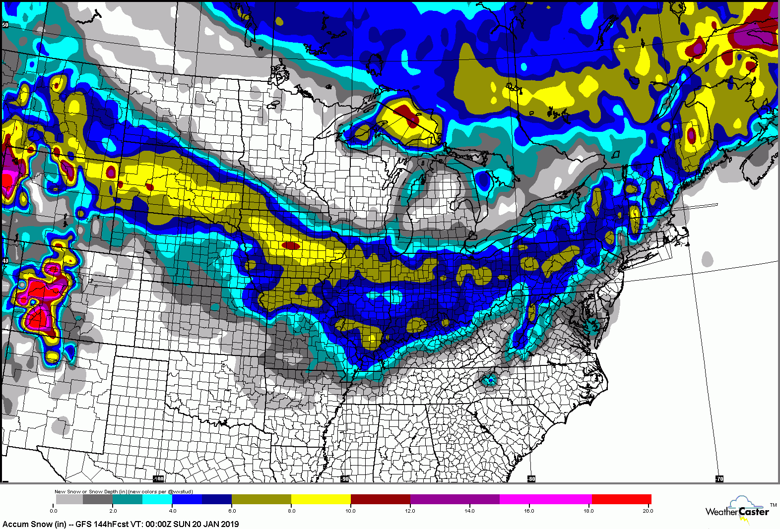
Loading... |
Reply to author |
Edit post |
Move post |
Delete this post |
Delete this post and replies |
Change post date |
Print post |
Permalink |
Raw mail |
![]() ![]() ![]() ![]() ![]() ![]() ![]() |
This post was updated on Jan 14, 2019; 12:06pm.
There is something that just popped up in the models for the 19th, let's see how this develops - seeing 8+ in the forecast so far.
Don't ski the trees, ski the spaces between the trees.
|
Loading... |
Reply to author |
Edit post |
Move post |
Delete this post |
Delete this post and replies |
Change post date |
Print post |
Permalink |
Raw mail |
![]() ![]() ![]() ![]() ![]() ![]() ![]() |
Administrator
|
I've been hearing chatter about that too among some weather mets fingers crossed thanks for starting the thread
"You just need to go at that shit wide open, hang on, and own it." —Camp
|
Loading... |
Reply to author |
Edit post |
Move post |
Delete this post |
Delete this post and replies |
Change post date |
Print post |
Permalink |
Raw mail |
![]() ![]() ![]() ![]() ![]() ![]() ![]() |
Latest GFS run is showing it. Lets hope the trend continues. GFS is also showing a steady stream of storm chances next couple weeks.
I know it's the GFS, but at least showing the potential is there. |
Loading... |
Reply to author |
Edit post |
Move post |
Delete this post |
Delete this post and replies |
Change post date |
Print post |
Permalink |
Raw mail |
![]() ![]() ![]() ![]() ![]() ![]() ![]() |
In reply to this post by Harvey
Your welcome
Don't ski the trees, ski the spaces between the trees.
|
Loading... |
Reply to author |
Edit post |
Move post |
Delete this post |
Delete this post and replies |
Change post date |
Print post |
Permalink |
Raw mail |
![]() ![]() ![]() ![]() ![]() ![]() ![]() |
Way way wa way way way way way way way way way way way way way way too early :) I'll check back in Tuesday at the earliest
|
Loading... |
Reply to author |
Edit post |
Move post |
Delete this post |
Delete this post and replies |
Change post date |
Print post |
Permalink |
Raw mail |
![]() ![]() ![]() ![]() ![]() ![]() ![]() |
Interesting article..
Looks like the gov shut down is making the GFS unstable https://www.washingtonpost.com/weather/2019/01/07/national-weather-service-is-open-your-forecast-is-worse-because-shutdown/
"Peace and Love"
|
Loading... |
Reply to author |
Edit post |
Move post |
Delete this post |
Delete this post and replies |
Change post date |
Print post |
Permalink |
Raw mail |
![]() ![]() ![]() ![]() ![]() ![]() ![]() |
That article is mostly fake news, skill scores haven't changed. GFS remains awful and the new version has not shown any increase in skill.
|
Loading... |
Reply to author |
Edit post |
Move post |
Delete this post |
Delete this post and replies |
Change post date |
Print post |
Permalink |
Raw mail |
![]() ![]() ![]() ![]() ![]() ![]() ![]() |
didn't know that interesting..
it has been awful in the long range
"Peace and Love"
|
Loading... |
Reply to author |
Edit post |
Move post |
Delete this post |
Delete this post and replies |
Change post date |
Print post |
Permalink |
Raw mail |
![]() ![]() ![]() ![]() ![]() ![]() ![]() |
We have had feet of virtual snow in the long range, reality is so far this winter has given the south east and mid Atlantic more snow than most of the Northeast with more tomorrow. NNE did very well in November and just had an epic upslope snow event. Gore and Whiteface have been on the edge. 95 inches at Face this year is a solid number but it's really November with a long break in December. Stowe is at 150 and that's the upslope
|
Loading... |
Reply to author |
Edit post |
Move post |
Delete this post |
Delete this post and replies |
Change post date |
Print post |
Permalink |
Raw mail |
![]() ![]() ![]() ![]() ![]() ![]() ![]() |
If that thing could just wiggle a little north it would be game time |
Loading... |
Reply to author |
Edit post |
Move post |
Delete this post |
Delete this post and replies |
Change post date |
Print post |
Permalink |
Raw mail |
![]() ![]() ![]() ![]() ![]() ![]() ![]() |
In reply to this post by JasonWx
Yea - and were going to have more hurricanes and earthquakes because of it. ![]()
Don't ski the trees, ski the spaces between the trees.
|
Loading... |
Reply to author |
Edit post |
Move post |
Delete this post |
Delete this post and replies |
Change post date |
Print post |
Permalink |
Raw mail |
![]() ![]() ![]() ![]() ![]() ![]() ![]() |
Looks like the models are still holding together for a major storm for MLK.
Don't ski the trees, ski the spaces between the trees.
|
Loading... |
Reply to author |
Edit post |
Move post |
Delete this post |
Delete this post and replies |
Change post date |
Print post |
Permalink |
Raw mail |
![]() ![]() ![]() ![]() ![]() ![]() ![]() |
Administrator
|
The storm starting time... any have theories or data?
"You just need to go at that shit wide open, hang on, and own it." —Camp
|
Loading... |
Reply to author |
Edit post |
Move post |
Delete this post |
Delete this post and replies |
Change post date |
Print post |
Permalink |
Raw mail |
![]() ![]() ![]() ![]() ![]() ![]() ![]() |
I saw snow showers on Friday, and the big one hitting on Saturday. Very dry and seasonably cold before then.
|
Loading... |
Reply to author |
Edit post |
Move post |
Delete this post |
Delete this post and replies |
Change post date |
Print post |
Permalink |
Raw mail |
![]() ![]() ![]() ![]() ![]() ![]() ![]() |
the last 3 runs have pushed the system south..If you believe the gfs, i95 corridor gets hammered
"Peace and Love"
|
Loading... |
Reply to author |
Edit post |
Move post |
Delete this post |
Delete this post and replies |
Change post date |
Print post |
Permalink |
Raw mail |
![]() ![]() ![]() ![]() ![]() ![]() ![]() |
Administrator
|
This post was updated on Jan 14, 2019; 4:02pm.
Open Snow is going with the southerly track too. NWS still talking about snow farther north.
"You just need to go at that shit wide open, hang on, and own it." —Camp
|
Loading... |
Reply to author |
Edit post |
Move post |
Delete this post |
Delete this post and replies |
Change post date |
Print post |
Permalink |
Raw mail |
![]() ![]() ![]() ![]() ![]() ![]() ![]() |
NWS has a foot on Saturday night. Sunday could be very very good. Hope they are right. Surprised Jason hasn't been calling for rain yet.
Don't ski the trees, ski the spaces between the trees.
|
Loading... |
Reply to author |
Edit post |
Move post |
Delete this post |
Delete this post and replies |
Change post date |
Print post |
Permalink |
Raw mail |
![]() ![]() ![]() ![]() ![]() ![]() ![]() |
Administrator
|
Looks Plattekill Magicish on the GFS map:
![]()
"You just need to go at that shit wide open, hang on, and own it." —Camp
|
Loading... |
Reply to author |
Edit post |
Move post |
Delete this post |
Delete this post and replies |
Change post date |
Print post |
Permalink |
Raw mail |
![]() ![]() ![]() ![]() ![]() ![]() ![]() |
In reply to this post by PeeTex
Still way way way too early. All possibilities remain on the table from Rain to the storm passing well south of the region.
|
Loading... |
Reply to author |
Edit post |
Move post |
Delete this post |
Delete this post and replies |
Change post date |
Print post |
Permalink |
Raw mail |
![]() ![]() ![]() ![]() ![]() ![]() ![]() |
Administrator
|
NWS ALY LONG TERM /THURSDAY THROUGH MONDAY/...
A return to a more active weather pattern appears likely from the end of the week into the weekend... Cold advection in the wake of this system for Friday/Friday night as high pressure noses in. For the weekend, there is general agreement that strong southern stream jet energy will carve out a deep trough over the southern Plains, with a surface low developing along the associated sharp baroclinic zone. There is potential for this trough to phase with a northern stream wave sweeping across the western Great Lakes. The result should be a full-latitude trough over the eastern Conus by Sunday. A widespread area of precipitation is expected with lift over the baroclinic zone and in the right entrance region of a strong upper jet, as well as in the deformation region of the surface low. There is good agreement in the deterministic guidance and GEFS in measurable precipitation over the local area late Saturday into Sunday with this system such that likely PoPs are in the forecast areawide. What remains to be seen is the degree of phasing and if it will result in a sharper, neutrally tilted trough by the time it sweeps into the eastern CONUS, or whether it will stay positively tilted resulting in an overall weaker system and more of a glancing blow. The former solution could result in at least moderate snowfall accumulation ... depending on the eventual track of the surface low, some mixed precipitation cannot be ruled out either.
"You just need to go at that shit wide open, hang on, and own it." —Camp
|