Christmas/New Years Holiday Weather (2011)
12


12
|
Administrator
|
This post was updated on .
This stuff isn't really right for the long term thread, so I'm starting a thread for whatever weather impulses come along between now and Jan 2:
From NWS Albany's Long Term Discussion: Tuesday and tuesday night...increasing clouds and milder conditions are expected as a frontal boundary moves east into the eastern great lakes. significant differences exist between the gfs...ggem and ecmwf regarding the timing of the front as well as whether or not a wave of low pressure over the southeast states tuesday morning tracks in our direction or slides off the coast well south and eastn of our region. The ecmwf is the farthest north and west and the gfs is farthest south and east. given the uncertainty will just include slight chance pops in the grids for now. expect highs on tuesday to be in the mid 30s to mid 40s with lows tuesday night in the mid teens to mid 20s. wednesday through thursday...expect generally drier and slightly cooler conditions with a chance for some light snow across northwest portion of fa on thursday as a clipper type system moves across eastern canada. expect highs on wednesday and thursday to be in the upper 20s to around 40 with lows wednesday night in the upper single digits to lower 20s.
"You just need to go at that shit wide open, hang on, and own it." —Camp
|
|
Pulled from FIS, regarding the 28th.
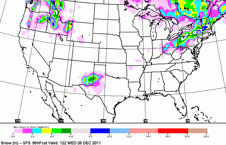
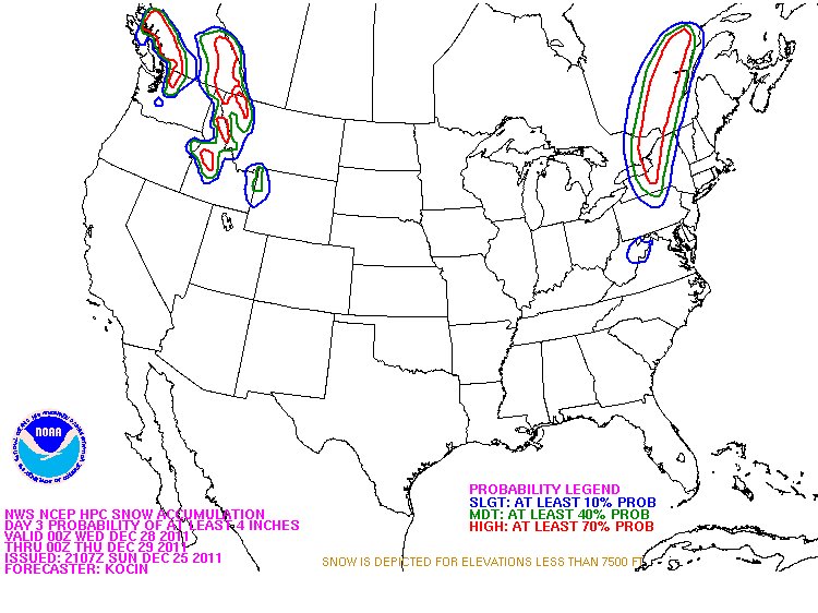
So it now looks like as the shortwave moves to our north it will intensify, maybe pick up some lakes moisture and bring a little more than snow showers across the higher terrain of the ADK and VT. Right now, both the GFS and the NAM show a much stronger “clipper” storm. Given history I’d say that it’s certainly possible that this event will move from the 0-3 range into the 4-6 range across the higher terrain. So Monday am, might be a nice time to get out and make a schuss. Now it looks like all the major models want to phase some northen and southern energy and produce a storm around the 28th. Seems reasonable and pattern has been fairly consistent that this would be a good time for a storm. I’m thinking that the primary low will stay towards the south and the prime target area will be the southern ADK and Central VT on into NH right now. Just sorta what my gut and the models tell me. This clearly will change. But for now, be aware something is brewing for mid-next week. Schuss more at: Holiday Weekend Weather (UPDATED…Now with Less Boooing) : Famous Internet Skiers - Earn Your Turns I'm hoping it hits late afternoon, so I can get some Thursday morning! |
|
Administrator
|
This post was updated on .
Seems like the key moment with be Tuesday when there is a chance for frozen or unfrozen or both. Still, we are in the game, which hasn't been true for most of the "season" so far. Forecast for WF looks pretty good right now, and it would take much to include NY areas further south.
GFS seems to be taking it seriously:  Looks like JasonWx's trip to Oregon may be looking up too.
"You just need to go at that shit wide open, hang on, and own it." —Camp
|
Re: Christmas/New Years Holiday Weather (2011)
|
Whiteface NWS point forecast for Tuesday is calling for 46 degrees at 3800 feet with rain and then 13 degrees that night. On Wednesday Whiteface will be a giant glacier. Whoppie!
What did we do to deserve this crappy winter or lack thereof
A true measure of a person's intelligence is how much they agree with you.
|
|
Administrator
|
This post was updated on .
 From NWS ALB forecast discussion tonight: STAY TUNED REGARDING THE TUESDAY NIGHT TIME FRAME AS SLIGHT SHIFTS IN THE STORM TRACK ARE POSSIBLE THAT COULD HAVE BIG IMPLICATIONS WHAT AREAS SEE WHAT PRECIPITATION TYPE.
"You just need to go at that shit wide open, hang on, and own it." —Camp
|
Re: Christmas/New Years Holiday Weather (2011)
|
looks like whiteface is getting 2-4 inches right now...stowe picked up over 5 inches today and its still snowing.
|
|
Administrator
|
This post was updated on .
Unfortunately the more detailed WRF seems to be on the fritz right now (still showing estimated snowfall from Christmas Eve).
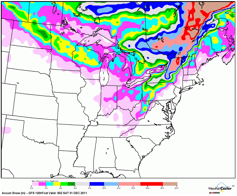
But the GFS seems to have the Adks still in play on this storm, especially Whiteface and Big Tupper:  Hard to believe that NoVT won't score too, possibly more on the backside. From NWS ALB Forecast discussion: Models now in very good agreement that the storm moving northeast into the region will track well inland...likely tracking just to the south and east of albany as it heads northeast into northern new england by wednesday morning. This type of track will likely lead to little if any snow from albany south and east...Including higher terrain areas such as the eastern catskills...Southern vermont and berkshire county. At best an inch or two may fall late tuesday night over the higher elevations just mentioned after the storm has passed and colder air begins to move in...With little if any snow forecast in the valleys. Areas to the northwest of albany will see a changeover to snow several hours earlier...so accumulations are likely there... Especially over the adirondacks. Have generally forecast about 4 to 8 inches over the northwest part of the aly adirondack zones... Decreasing to 3 to 6 inches over the southeast adirondacks and western mohawk valley...And 2 to 4 inches over the schoharie and eastern mohawk valleys.
"You just need to go at that shit wide open, hang on, and own it." —Camp
|
|
I think Gore needs to stop being the eye of the storm. Seems to be a common trend.

|
|
3-7" overnight Tuesday at MRG now according to NOAA. I'm really hoping for a new years miracle here though. They've pushed back opening day until Friday and I'd really like to get the lady up the single chair for a few long runs. And a few for me in the fall line while I'm at it.
Not to mention that I'm hoping to put a dent in my stack of tickets for the Middlebury Snow Bowl. It'd be great if this cold front could just last until June. |
|
Administrator
|
This post was updated on .
Fuje as you know that image shows lake enhanced snow getting picked up again on the spine of the greens. That ain't changin.
You just never know. Fingers crossed. Current track is definitely more inland than that GFS porn I posted above. A couple more runs to go. Tweet from Lionel:  I can't imagine a more noble goal for the season.
"You just need to go at that shit wide open, hang on, and own it." —Camp
|
Re: Christmas/New Years Holiday Weather (2011)
|
last night the WF point forecast at 3800 ft said 5-9 " but now says only 1" and lots of rain - we are totally screwed
A true measure of a person's intelligence is how much they agree with you.
|
Re: Christmas/New Years Holiday Weather (2011)
|
This post was updated on .
CONTENTS DELETED
The author has deleted this message.
Syracuse, NY
|
Re: Christmas/New Years Holiday Weather (2011)
|
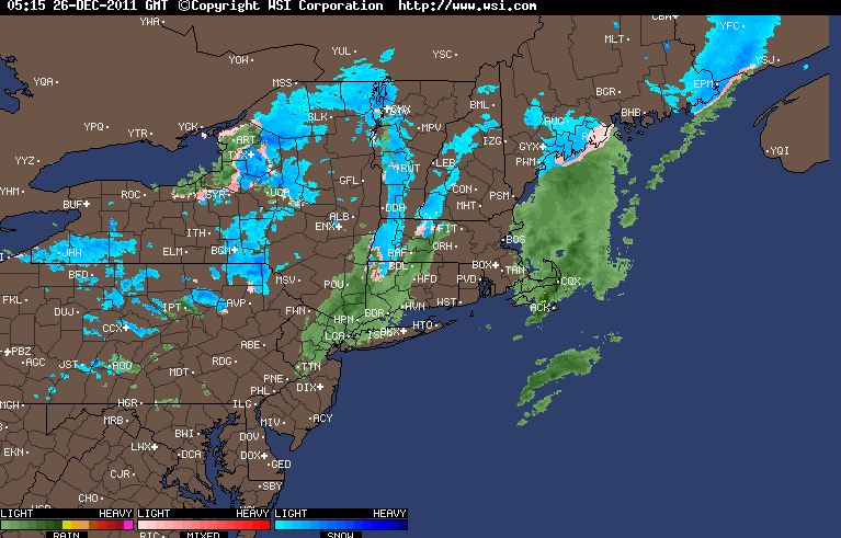
We are totally screwed, its not just "some" rain. Its going to pour tonight, any progess Gore and Face made will be lost.
|
|
In reply to this post by 70s Gore Kid
<quote author="70s Gore Kid">
No, youre not screwed in the Adirondaks. A little cold rain wont hurt the base. Unfortunately we don't have much of a base...so what little we have will be hurt.
Avitar=Left Gully, Tuckerman Ravine
No Fat Chicks, Just Fat Skis |
|
the snow for the MRV flipped back to a 1/2" - 1" of rain. I can't help but feel like we've earned ourselves a no thaw season at the least. Are there any indications that winter is going to arrive soon?
|
Re: Christmas/New Years Holiday Weather (2011)
|
In reply to this post by 70s Gore Kid
That was terrifying. If Harv run a blog for that region, he would have to call it Harvey WROD.
Love Jay Peak? Hate Jay Peak? You might enjoy this: The Real Jay Peak Snow Report
|
Re: Christmas/New Years Holiday Weather (2011)
|
I hate it when weather forecasters are right, especially when it's Darrin at ADK Weathersite out of Indian Lake. He has been pretty much spot on this fall, unfortunately for all us skiers. He is predicting lots of warm air tonight resulting in mostly a rain event for all of the Dacs. Bummer.
|
|
In reply to this post by Sick Bird Rider
Maybe they will get spared. Wasn't this supposed to start as rain and transition to snow? Snowing pretty good in Speculator now
Webcam |
Re: Christmas/New Years Holiday Weather (2011)
|
no, its a brief period of snow to hvy rain. Maybe some light snow at the end
|
Re: Christmas/New Years Holiday Weather (2011)
|
In reply to this post by 70s Gore Kid
That Sugar Mountain video looks like the Hovey ski race of 2007 at Whiteface. The first weekend of January and we were shoveling snow onto the race course. The kids had to take off their skis and walk through mud to the start on Boreen...but then everything changed on MLK Day(hopefully we won't have to wait that long this season) and there was a particularly good powder day(EPIC!) in mid February
 Enough with the dooms day stuff...it's going to get cold on the backside of this system and we will all recover quickly. I plan to be out on the hill with very sharp skis this week. My kids will be there tomorrow...might be very windy though and I'll be back on Thursday for...
Proud to call Gore My Home Mountain
Covid stole what would have been my longest season ever! I'll be back |
«
Return to Weather Archive
|
1 view|%1 views

