Google Earth Ski Maps
123
123
|
What's the aspect of that slope? I don't think it's north. It might not be worth clear cutting a run that wasn't going to incorporate snowmaking. Your efforts might be better put into an area that retains snow better. Just a thought.
It does look like that spot should have a trail tho! Especially if it's a good long cruising blue run, that's the sort of trail that Plattekill doesn't have much of. The one or two runs under the triple are about it if I remember correctly. Most of the blues off to the sides or on the ridge lines I kind of remember being more like greens but it's been a long time. |
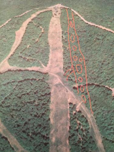
 I was thinking something like this. Pockets or islands of perfectly spaced glades in between open spaces (wide enough for a groomer or snowmaking) and connecting to the trail below instead of back to the main trail under the chair. This would create a more long fall line option completely different from the other ways down but by having the small crossover connection trail the system is braided creating many different options without creating a bunch of new lines. I think it would be optimal for powder skiing and a completely unique experience compared to what already exists. I'm sort of imagining something very Mad River Glen like. But because of the aspect maybe it's not the best location for a trail like that? I dunno. |
|
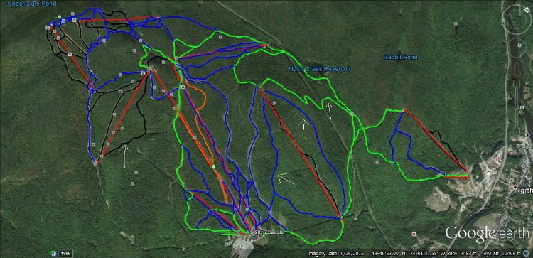
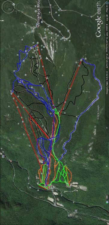
I'm eventually going to post all my maps. I'm doing Whiteface and Gore first. I have white arrows next to everything that I added that wasn't already there. For Gore, you'll notice the expanded terrain on Burnt Ridge, as well as an additional trail on Topridge.
 I added an additional trail to Lookout that I called Ridge Run that would be a narrow trail with plenty of twists and turns. Of course there would be snowmaking, cause all the trails I add are supposed to get it. I also made Rand's Last Stand a trail to allow for direct access to the Summit Quad from Lookout, meaning no need to go down and around through Little Whiteface to reach it. I also would like to see Lookout Below widened to make it easier to ski laps on the Lookout Triple without going to the bottom. This is all being done with the intention of naturally dividing terrain by encouraging advanced skiers to stay on the upper mountain and not return to the base till the end of the day. 
I've lived in New York my entire life.
|
|
In reply to this post by raisingarizona
Arizona, it is not exactly a northern aspect. But in my original post, I said that it would definitely have to be a trail with snowmaking as it would be narrow, steep and skied off easily without it. Possibly by dragging hozes from Face, and using Ground guns. As far as the north side goes, theres tons pf trails over there, and I can't see adding anything on that side being a big deal. I would keep the trail narrow (about the width of a groomer or two) so that it would be easy to make snow on, and be protected by shade. Although the idea would be never to actually groom it after the snow is spread out. Just like Chute but straight down. Having clusters of trees would complicate snowmaking, but I could see leaving a few of the biggest, oldest trees that are difficult to remove. Also, it would have to end before Crossover, which is a beginner trail. You have it ending lower down the hill, and that could create a dangerous situation, because it's crossing over a beginner trail.
I'll take boilerplate ice over wet snow any day
|
|
In reply to this post by Harvey
Harvey, I love your enthusiasm! What exactly are "my people"?
I'll take boilerplate ice over wet snow any day
|
|
In reply to this post by Ethan Snow
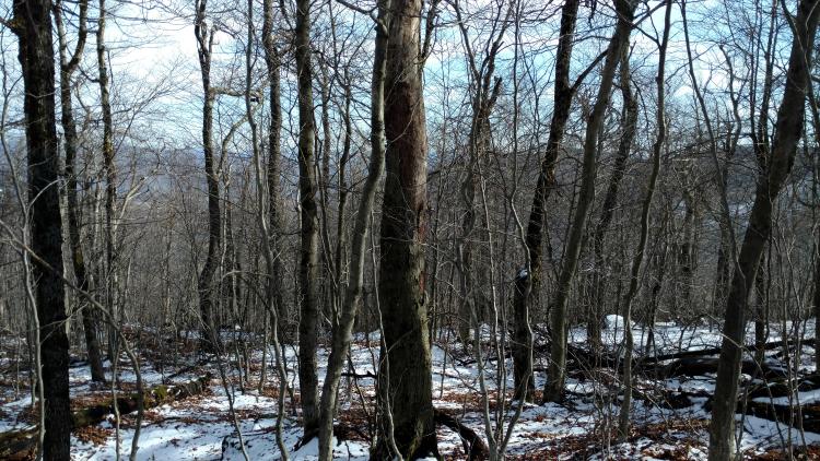
I went back and looked at Ethan's trail again. I like it better now. It actually does have a nice hook towards the bottom which I think follows the contours pretty good. I think it actually should be left mostly natural though, just clear enough small trees that you can see there's a trail there and let it be gnarly except after a storm. What makes Plattekill special is that it feels kind of wild. I don't want to spoil that with too much trail density. If you clear the under brush around the new trail more people will ski those trees (some do already) and you'll end up gladed out over time I think. Then we can all be happy.
Sno I would critique your gore plan but I'm not familiar enough to offer anything useful. I only get there once in a while. Lots other gore skiers here though
"You want your skis? Go get 'em!" -W. Miller
|
|
This post was updated on .
In reply to this post by Ethan Snow
Ah, I see. That totally makes sense. I wasn't sure about snowmaking and having clusters of trees. The only other thing I'm wondering tho is why can't your proposed trail cross over Crossover? Maybe being that Crossover doesn't actually continue to another beginner trail your proposed trail could be seen as more valuable and needed? Maybe close crossover or just mark the intersection? How much traffic do you really get on Crossover and how fast would traffic be coming down the new line? Maybe you are right but I would think there could be a way to make it happen. Is Crossover a "clutch" trail for the system? It's hard to tell from here but imo your proposed trail looks like it would be a lot more used and appreciated where as Crossover is just sort of....there. Either way it would be a great addition to that side of the mountain. Edit: Another thought Ethan is that you can slow the traffic by creating pinch points before your intersections. So your proposed trail could become progressively narrower or flatter before it crossed Crossover. this depends on the terrain somewhat but I'm sure you could think of something. Again, just some ideas and thoughts, I have no idea about the actual lay of the land or what would be best, it's been 21 years since I have been there! |
|
There is a bermed mountain bike trail that runs through the area you have identified on the triple side. IMHO, it is a hell of a lot more fun to ski than anything anyone has proposed in this thread.
Again this is IMHO, but Platty doesn't need any new trails cut...at least not at this juncture. I'd like to see snowmaking on Ridge and Twist and the brush between the existing trails trimmed in some areas. It's pretty close to perfection as it is, don't go messing with things. |
|
Administrator
|
In reply to this post by Ethan Snow
Ethan the my people thing is kind of a joke that symbolizes joining the power of our two organizations. Reality is I have no people.
Plattekill has maybe 50% (?) snowmaking? Marcski... any idea on the real number? Cutting a trail that requires snowmaking and won't get it for several years doesn't make sense. If the long term plan is to put a trail there, let's clear a tree skiing line or five. To take it farther, since natural snow is getting harder to come by, I'd rather make sure all the lines with favorable aspects are cut first, which I think means the double side. Also IMO chainsaws should be used sparingly for cutting up already downed wood. My two cents.
"You just need to go at that shit wide open, hang on, and own it." —Camp
|
|
As far as %tage of trails covered with snowmaking...you're probably about right, Harv.
Skier density just does not necesitate cutting any new trails at Platty. Like I said, IMHO, first upgrades or capital improvements at this point are snowmaking on Ridge and Twist. It would probably only require one (set) pipe(s) (depending on whether you want to run electric and water for fan guns or water and air pipes). And, yes, I heard there was some grumbling about all of the chain saw usage at the last glade cutting day this past fall. Trimmers and clippers are all that is needed most of the time. |
|
Yup, this all makes sense.
So what's wrong with chain saws? They get it done, no? |
|
In reply to this post by Harvey
Harvey, Plattekill claims 75% snowmaking, although this may be a bit of an exaggeration. Maybe in terms of actual square footage, it's close, but in terms of #trails, it's a little high.
http://www.plattekill.com/mountain-info/about-plattekill Ps. That guy on Face is my brother Joe Snow, followed by John T.
I'll take boilerplate ice over wet snow any day
|
|
Administrator
|
 Son of Empire
"You just need to go at that shit wide open, hang on, and own it." —Camp
|
|
The more I think, the more I like this idea. Maybe start out by just clearing the brush and smallest trees along the route in order to retain the Platty/MRG character. Let it be a natural snow, ultra narrow off map secret initially.
"You want your skis? Go get 'em!" -W. Miller
|
|
Mr. Brown, why are you comparing Platty to MRG? Plattekill actually has quite wide slopes. Besides, Mad River is closed while Plattekill is still making snow!
I'll take boilerplate ice over wet snow any day
|
|
Snowmaking, grooming, and high speed lifts for MRG!!
 Widen, straighten, and homogenize all the trails while you're at it!!  P.S. Just kidding, leave it the way it is. I haven't skied there and don't plan on it so why do I care what happens.
I've lived in New York my entire life.
|
|
This post was updated on .
In reply to this post by Ethan Snow
Not comparing. I just feel a similar vibe from both places. I don't think it's a knock. Mad River does have some wide slopes but I think we would agree it's the crazy terrain under the single that make it special. I like Plattekill the way it is so I hope, as improvements come, they don't change the character of the place.
Edit: what I meant to say is that, like mad River, Plattekill has wide slopes and snowmaking, grooming etc but it's the trees, the narrow trails and the go-anywhere-you-feel-confident attitude that, for me, set it apart from other hills.
"You want your skis? Go get 'em!" -W. Miller
|
|
In reply to this post by snoloco
Snoloco,
Some day you will want to ski MRG. I know you have a grand plan to rent Plattekill as a group which I think would be a blast and, if you do, I hope I make it. But I think you and your dad should head up there and check it out as soon as you have a chance. Next weekend is my recommendation. It's a cool place. The statistics don't always tell the story.
"You want your skis? Go get 'em!" -W. Miller
|
|
Administrator
|
In reply to this post by Brownski
This is in line with my thinking but I still think all of the northeast facing stuff should be treed first. Plattekill has no need for more trails.
"You just need to go at that shit wide open, hang on, and own it." —Camp
|
|
In reply to this post by snoloco
Your WF additions are exactly what is already approved/awaiting funding.

I ride with Crazy Horse!
|
«
Return to Woodstove Archive
|
1 view|%1 views

