Google Earth Ski Maps

123
123

|
I have made a bunch of trail maps on Google Earth. I find them really fun to make because it gives me a really good idea of a mountain's layout without having skied many days there.
I have maps for Mount Peter, Tuxedo Ridge, Mountain Creek, Hunter, Windham, Belleayre, Plattekill, Gore, Whiteface, Mount Snow, Stratton, Killington, Pico, and Stowe. With the Gore, Whiteface, Killington, and Pico maps, I plotted additional trails/lifts that I would add. For Gore, I added 3 trails to Burnt Ridge and one trail to Topridge. For Whiteface, I added a trail to Lookout Mountain. For Killington/Pico, I connected them, reopened upper Ramshead, and reopened the Northeast Passage section. Now with what I said about it being easy to see a mountain's layout without having skied there many days. I saw how well laid out mountains actually looked as well as poorly laid out ones. I find Mount Snow to have the best trail layout of the mountains that I mapped. IMO, a good trail layout is one with few bottlenecks and runouts and intersections, but with direct and indirect lift redundancy. BTW, I define runout as a trail that isn't steep enough to make turns on while still keeping your momentum up. They are different from traverses as you need to take a runout on every lap, while a traverse you only take to get between mountain areas. I just came up with the terms about lift redundancy, so here's how I explain them. Direct lift redundancy is when one lift runs right next to another, starting and ending at the same location. Indirect redundancy is when a lift serves a portion of a trail section making the trails near it easier to lap, but does not serve other parts of the section. Hunter's D and F-Lifts are indirectly redundant with the 6-pack. So why is Mount Snow's layout so good? There are no sections that are completely dependent on one lift. If the bubble chair goes down, you've got the Grand Summit Express right next to it. If that goes down too, you can still access every Main Face Trail using the Canyon Express, Ego Alley, Sundance, and Challenger lifts. If Challenger on the North Face goes down, they have Outpost as a backup. Same is true with Carinthia and Sunbrook. Two lifts have to go down before any terrain closes. It also takes the same number of lift problems to isolate a section. In comparison, at Gore, if the Burnt Ridge HSQ goes down, the Burnt Ridge trails are inaccessible, and the Ski Bowl is isolated. You can get in, but not out. As for the trails, there are a couple bottlenecks, but not very many and not for long. Runouts are basically nonexistant, except for River Run on the North Face. While Stratton has great lift infrastructure, the trails aren't as well laid out as Mount Snow's. There are tons of long and incredibly flat runouts (earning the nickname Flatton). If a lift goes down, you are going to be taking a runout every single run. On some trails, runouts are nearly unavoidable. For example the Kidderbrook Area of the Sun Bowl doesn't have its own lift anymore and requires a two lift rides and a long runout to lap those trails. Gore has very few bottlenecks and only one significant runout that must be taken every lap (Cedars), but has many areas that are dependent on a single lift. This means that if a lift goes down, you can't access the terrain. There are also many traverses to get between sections. Killington has the lift redundancy that I consider good, but has way too many bottlenecks and intersections. What is your criteria for a good mountain layout? Also, I may post screenshots of my maps later in this thread.
I've lived in New York my entire life.
|
|
Administrator
|
This post was updated on .
I once read something by an architect of small buildings that spoke to me: "The appeal of a small building is that can be imagined in it's entirety all at once." I feel that way about our cabin. I can imagine it all all once. I feel the opposite about a ski mountain. Single ridge mountains (blacks in the middle, greens on the outside, blues in the middle) have some characteristics some really value, like no skating. But I am more interested in a mountain I can't comprehend easily. It's one reason I love Gore: East Side comes to mind first, then the North. Topridge and then Straightbrook. Darkside. Rumor and Lies. All the trees in the Straightbrook Bowl. Twister, Echo, Sagamore and the trees on BR, Abenaki and Cirque. Ski Bowl. Raymond Brook. Gore to Garnet. Tons of stuff I'm not at liberty to name. Sugarbush is like that. Awesome. You can't ski it all in a day. It's beyond imagination. On a huge day when the snow is good and it's all in play... there is no easy answer to the question... what do we do next?
"You just need to go at that shit wide open, hang on, and own it." —Camp
|
|
|
This post was updated on .
Nice. A mountain with lots of folds, creases, and lots of varied undulating features usually hide secrets and goodies not so easily obtained. I think those places take time to get to know and develop a close relationship with. I can dig a simple layout too, you know to just get it done but a mountain that doesn't give things up so easily is really special.
HA! Are we talking about ski mountains or woman? Well....not the thing about folds and creases. :) One thing Sno about a trail layout for me is to keep trail areas or pods separated appropriately. And by that I mean don't have a long chair that is 50% flat and 50% steep just to claim that you have a 2000 vt. chair. Break it up, as an experienced skier I would much rather make shorter laps than ski further down on terrain I don't care for, to then only get stuck sitting on a chair longer than needed. the other side of that is you can keep a lot of people from using chairs that they don't belong on as well. I don't think a beginner wants to have to ride up on to the steeper areas and clog up the one easier way down, they would probably be happier on a shorter lift skiing on terrain they are more comfortable with anyways. I think that helps with everyones experience overall. Another thing I like is long uninterrupted trails. I think having as little merges/intersections and crossing catwalks as possible really creates a better experience. As a kid I never like Killington, it's just so confusing and stuffed with uninteresting trails and catwalks. It always seemed wasteful to me. Another aspect would be keeping it looking natural. Out east I don't really like all of the pipes, hoses, power lines, fences, and the guns on the poles lining the trails. I also don't like how some ski areas have planted trees in places looking like a tree farm or how ski runs look like huge power line clear cuts. I like to think there could be ways of making everything blend better into the natural environment. If I'm skiing I want to feel like I'm in the mountains, not a city park. Two words describing what I would strive for in a trail system are connectivity and continuity. Something that flows well and doesn't create confusion or chaos. Maybe that sounds weird but it makes sense to me. |
|
|
What a lot of people like about Plattekill is that you can "imagine it all at once". Blacks straight down the middle, greens on the outside, and blues mixed in. Obviously there's no lift redundancy or run outs there.
I have relocated my rope tow three times in five years at Woodstream. Ironically, the most recent re-Location involved adding a "run out" to our main trail/terrain Park. It was well worth it because it allowed for much more tree skiing and more trails and more vert. It's great when we have snow, but it's a pain to make snow on. In fact, I'm now considering adding an additional tow that serves the upper half of the hill for this very reason. It will be easier to have terrain open in bad seasons like this. I will simply repurpose the mechanics from my old system that I replaced. No promises yet. :) This is something to consider for all ski resorts. Killington has the Snowdon tripple which they can get open in October because it's easy to make snow there. Everyone should have an early season plan. A lift in an area that holds snow well, and allows them to get good skiing open without having to cover a lot of area. Showcase at Gore is a good example of this. Sno, I'm interested in seeing your ideas for Plattekill. I have always thought of a trail about the width of Empire at WF that comes straight down skiers left of Upper Face, starting just down Powder Puff.
I'll take boilerplate ice over wet snow any day
|
|
|
Not every ski area rushes to open. Mount Snow tends to open a bit later than Okemo, but offers much more terrain. I read their GM's blog and according to it, they like to be open top to bottom, with terrain for all abilities. This translates to having the Cascade to Canyon route, the Launch Pad learning center, a park on Carinthia (usually Nitro), and connecting it all with Long John. If it's a good year, they add Little John, Deer Run, Ridge, and Snowdance. Bluebird Express, Nitro Express, and Discovery Shuttle Triple typically spin. If Snowdance opens, Canyon Express will spin too.
Stratton's layout has the issue of the lower half being a flat runout while the top has decent pitch. This applies to the main mountain and the Sun Bowl area is different. The two lifts that serve the upper terrain are the Snow Bowl Quad and URSA Express 6-pack. Snow Bowl doesn't operate every day and if it's closed, you get to take a lengthy runout to the gondola. At the Sun Bowl, all the main trails have decent pitch all the way to the bottom, but there are these few trails in what was the Kidderbrook area. It used to have it's own fixes grip quad, which was removed in 2007. Now, lapping those trails requires two lifts to get up, and a long runout at the bottom. The one day I skied there, I always ended up finding myself on these ridiculously flat runouts (even when trying to avoid them) which is the biggest downside of Stratton.
I've lived in New York my entire life.
|
|
|
Sno
I'd be interested in seeing some of those maps. One of the many many things I find cool about Mad River is that they give you an actual contour map for a trail guide. I think it indicates a higher level of respect for their customers' intelligence. I agree with you guys about the attractions of long continuous trails but I think you're being hard on Killington. All those low angle greens are there for a reason and there actually are areas all over the place where you can just hang out on a single lift and do uninterrupted (or nearly so) laps. The bear quad, needles eye, canyon (with 1 interruption I admit but it's my favorite any way). Then there are places where intermediates can do the same thing. Where I always run into trouble there is when I ski with a mixed group. If it's me and one of two guys that can keep up, it's the best
"You want your skis? Go get 'em!" -W. Miller
|
|
|
Sno, you should check out caltopo. You can plot out trails and get the steepness, vertical, and aspect on the spot, and toggle between topo and satellite maps. You can also upload your maps to a phone by using the Avanza PDF maps app.
|
|
Administrator
|
Plattekill is fascinating to me, especially when you consider the goodies along the ridge. (Just stay off the farmers land! :)
Also how many mountains allow you to sample an Ommegang while looking at the front four? 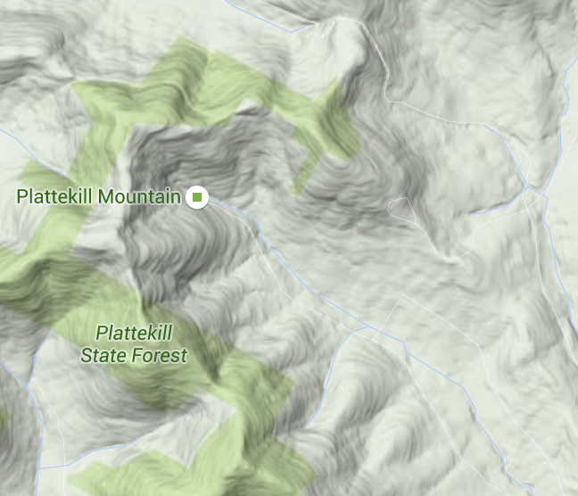 And OH YEA there will be boundary to boundary tree skiing by the time NYSB gets done with that mountain.
"You just need to go at that shit wide open, hang on, and own it." —Camp
|
|
|
This post was updated on .
When I was quite young, I made a map of what we know of as Franklin Mountain in Oneonta. It has an astonishing 1050 vertical for the northern foothills of the catskills. It holds snow pretty well. The only problem is that state highway 28 goes over it. It's a crazy section of road that I drive about 6 times a week going to school, and skiing. On a normal winter, it really does feel more like a green ski slope than a road. I had all the trails laid out over the topography. My plan was to re-route 28 behind the mountain and have it connect back to 1-88 another exit east. Then the road would become my 2 mile long cruiser. Every day as I drive the road, I imagine HKD snow guns mounted along the side, and I imagine slopes dropping off the 45% pitch which I am driving along. The resort would have two peaks. For lifts, I had one 6 pack, two HSQ's, and two fixed grip lifts. One which served a small but very steep area in the middle all on its own, and the other would be indirectly redundant with the six pack, serving beginner terrain only. I was also planning on taking over a church located at the bottom of the mountain and using that as the base lodge. There's a gun club at the top which would make a perfect summit lodge.
It was all just in my imagination, but if I can find the drawings, I will post them. It was awesome, and I forgot about it until Sno mentioned Google earth ski trail maps. I have them filed away somewhere. What made this mountain ideal to me was that it would be located within feet of a large water source, and also an interstate highway, so it would attract attention. It's close to a waste water treatment plant, and electrical sub stations, so those facilities would be easy to come by. You would have a view of the town/(city) when you are skiing, and there would be plenty of hotels, restaurants, and other things that tourists could do while their visiting. As I said, it's just a dream, but it's sorta my ideal setup.
I'll take boilerplate ice over wet snow any day
|
|
|
I didn't add any changes for Plattekill. I've only skied there once, so I don't really have an idea where the issues are, outside of lack of snowmaking, which is already being solved each year little by little. The lifts are fine. No need for high speed quads unless lines get much longer, plus they're Hall's, so they're not going to die.
I'll add this to the Stratton map when I get the chance, but I want to add a 6-pack to replace the Snow Bowl Quad and a low capacity (1,800 pph) HSQ where the Kidderbrook Quad used to be. Also, add a trail to that section. This would make it possible to ski all the trails without taking a flat, boring, runout.
I've lived in New York my entire life.
|
|
|
Impressive Loco!

I ride with Crazy Horse!
|
|
|
As a WF lifer I need vertical. It's the result of skiing long continuous terrain. Nothing worse for me than spending 10-20 or longer in a line, then 5-12 on a lift to only get to ski 35 to 50 seconds. Can't, I mean just won't do it.
Aspect is critical as well. Def need terrain that faces northeast to protect from sun. Also nice to have a couple trails on the southern side for late afternoon sunset runs. Parons is a nice example. Narrower. Hoyts High is a perfect width. Fall line shots are great but I also love skiing across the fall line. So a continuous trail that switches back gradually against the fall line is super fun and interesting to ski. Rolling. Steep to short flat to steep is a blast. Woods Pods. Gladed zones between trails is great.
I ride with Crazy Horse!
|
|
|
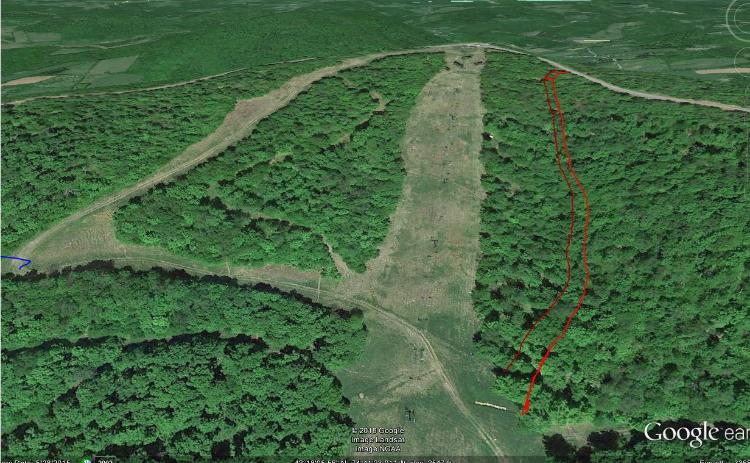
this trail would really add a lot to Plattekill. I've skied right through this in the woods, and I really likie it, But the brush is too thick. Empire at WF measures 15-20' wide on Google Earth which is what this is it's actually about 5 feet wider. I wouldn't even think about snowmaking, I would just do it hands down. You could actually use ground guns and run hoses from Upper Face Just imagine, 6' High moguls, the Catskill equivalent of Lookout Below. I would do anything for this trail, even if I had to do all the chain saw work myself--I would. Gotta figure this out somehow.
I'll take boilerplate ice over wet snow any day
|
|
|
I like it but if we're cutting trails there, lets do a switch-back trail like Chute
"You want your skis? Go get 'em!" -W. Miller
|
|
|
In reply to this post by Ethan Snow
It would be a cool spot for a trail that has islands of trees and glades throughout. Make it in a way that a slightly different line could be experienced every run.
|
|
|
In reply to this post by Brownski
Wouldn't that make it sort of flat and sucky for powder skiing? |
|
Administrator
|
This post was updated on .
In reply to this post by Ethan Snow
Have your people call my people. We'll tag this out, get LV approval (cake) and work through it with a very light touch. This summer.
"You just need to go at that shit wide open, hang on, and own it." —Camp
|
|
|
In reply to this post by Brownski
I know the place very well and it's one of my favorites. I like the Needle's HSQ a lot because it drops off you below trail intersection extravaganza at the top of Skye Peak. Canyon area is good because it's expert only. I skied 5 laps on Cascade one of the days I was there this year because it was so good with freshly made snow. No gondola line and very few intersections. Skye Peak Express and Bear Quad serve good terrain, but the bottom is a major bottleneck with traffic from both lifts becoming one. Snowdon is by far the worst with the bottlenecks and intersections. It is bisected by Great Northern twice which makes the skiing pretty disjointed. Breaking up Great Northern into separate trails might discourage people from lapping the K1. It's not positioned as a lift to take runs on, only to access the North Ridge and Canyon areas, or ski over to Bear.
I've lived in New York my entire life.
|
|
|
In reply to this post by Harvey
Maybe I should have said zig zag instead of switch back. Chute is my model
"You want your skis? Go get 'em!" -W. Miller
|
|
|
Naw, leave chute on the right, and this trail will be straight down. Just like Empire. My favorite. With enough hands, and chainsaws we can do this. I have also have access to some excavation equiptment. I figure make it just wide enough for a groomer to get up.
I'll take boilerplate ice over wet snow any day
|
«
Return to Woodstove Archive
|
1 view|%1 views