Google Earth Ski Maps

classic Classic list List threaded Threaded
47 messages Options
123
Reply | Threaded
Open this post in threaded view
|

Re: Google Earth Ski Maps

snoloco
Also in the plan, although I can't show this on a trail map is more snowmaking capacity to allow Lookout to open by Christmas and start blowing Cloudspin again.  More snowmaking is always in my plans.
I've lived in New York my entire life.
Reply | Threaded
Open this post in threaded view
|

Re: Google Earth Ski Maps

GoreMountainLodge
Hey Sno.  At Gore, on your plans, maybe extend the Sunway chair (with a new lift) to the old midway gondola station, and send a trail down to the topridge chair from there.
Mark Parobeck, principal
GoreMountainLodge.com
Reply | Threaded
Open this post in threaded view
|

Re: Google Earth Ski Maps

x10003q
In reply to this post by Brownski
Brownski wrote
The more I think, the more I like this idea. Maybe start out by just clearing the brush and smallest trees along the route in order to retain the Platty/MRG character. Let it be a natural snow, ultra narrow off map secret initially.
SE aspect means very narrow, unless it gets snowmaking.
Reply | Threaded
Open this post in threaded view
|

Re: Google Earth Ski Maps

raisingarizona
x10003q wrote
Brownski wrote
The more I think, the more I like this idea. Maybe start out by just clearing the brush and smallest trees along the route in order to retain the Platty/MRG character. Let it be a natural snow, ultra narrow off map secret initially.
SE aspect means very narrow, unless it gets snowmaking.

 Yup, I think the aspect is a deal breaker. I wouldn't waste the man hours/energy in that project when there is a better pitch and terrain on the already existing north faces.
Reply | Threaded
Open this post in threaded view
|

Re: Google Earth Ski Maps

Brownski
All true. The aspect is a concern, more reason to keep it narrow. I still think Ethan's original route has merit though. The other side has some real good trails zigzagging through the woods already. I wouldn't want to straighten or interrupt any of them. One mitigating factor might be wind. When it blows at Plattekill it seems to blow west to east, right in your face as you reach the top of the triple. I would bet it deposits a lot in that area. Maybe not. I'm a nut for really narrow trails... Wishfull thinking maybe.
"You want your skis? Go get 'em!" -W. Miller
Reply | Threaded
Open this post in threaded view
|

Re: Google Earth Ski Maps

snoloco
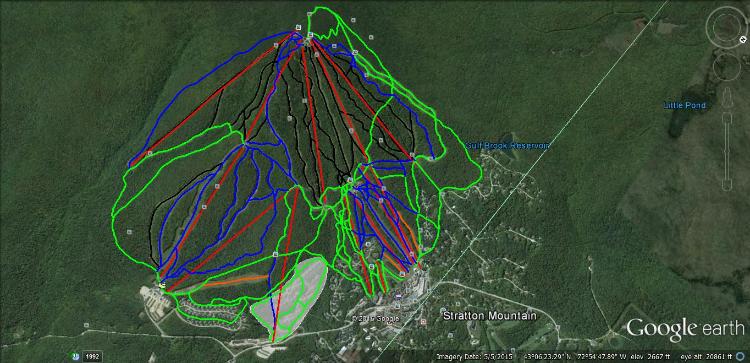
I came up with some expansions/improvements for Stratton.

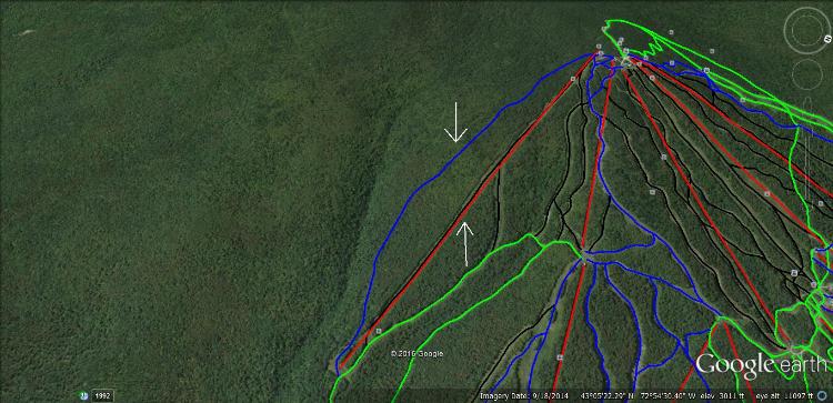
Upgrade the Snow Bowl Quad to a high speed 6-pack.  Capacity=3000 pph.  This lift is intended to serve as a way to lap the Snow Bowl trails without taking the runout to the base if you want to ride a high speed lift.  It doesn't need and shouldn't have 3,600 pph like the URSA Express has because it isn't the primary way to the summit.  The Gondola is the primary route to the summit from the main base and URSA is the primary route to the summit from the American Express and lifts that end at the mid mountain lodge (South American Quad, Tamarack Triple).

Install a HSQ on the old Kidderbrook Quad line and cut a new trail to skier's right of the lift.  Capacity=2000 pph.  It doesn't serve a huge amount of trails, so it doesn't need full capacity, and it wouldn't overcrowd the trails either.  Purpose of this installation is to make it possible to lap the Kidderbrook trails without taking the annoying, flat, runout to the bottom of the Sun Bowl.

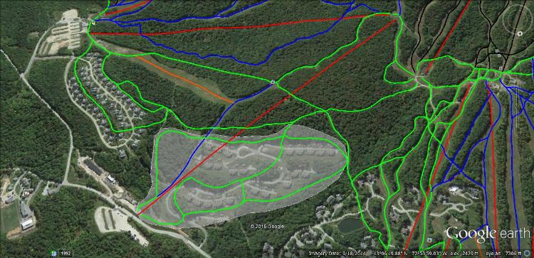
Relocate the original Snow Bowl Quad to run from Parking Lot 2 to the top of the Solstice Quad.  New trails would be cut to make a condo development near there ski-in/ski-out.  Also, that parking lot is lift served and doesn't require a bus anymore, which would take significant load off the bus system, which I imagine gets very crowded in the morning and afternoon rushes.

I've lived in New York my entire life.
Reply | Threaded
Open this post in threaded view
|

Re: Google Earth Ski Maps

snoloco
Here's the pictures.

Full mountain view.  New terrain is highlighted in white.


New lift closer view.  New terrain is highlighted.  That blue trail down to the said lift already exists.  You just can't get a lift out and have to take a bus.


Kidderbrook area.  New lift and trail have arrows pointing toward them.
I've lived in New York my entire life.
123