Storm Speculation: 1/12/12

classic Classic list List threaded Threaded
49 messages Options
123
Reply | Threaded
Open this post in threaded view
|

Storm Speculation: 1/12/12

Harvey
Administrator
Seems like it's time for this thread, or maybe even late.

It's going to be a messy storm. But I like being in the game.

Lionel Hutz:

http://www.famousinternetskiers.com/potential-major-winter-storm-easy/
"You just need to go at that shit wide open, hang on, and own it." —Camp
Reply | Threaded
Open this post in threaded view
|

Re: Storm Speculation: 1/12/12

frosty
Once again, Adk Weather Site less bullish on snow prospects than FIS.  "Marginally colder air" and "significant snowfall (6+ inches) unlikely."  Darrin's track record has been quite accurate this winter.
Reply | Threaded
Open this post in threaded view
|

Re: Storm Speculation: 1/12/12

JasonWx
right now I can not side with lionel..this looks like a mix to rain then back to snow.. no significant accumulation..
"Peace and Love"
Reply | Threaded
Open this post in threaded view
|

Re: Storm Speculation: 1/12/12

Harvey
Administrator
At least the matter is up for discussion.  With a pattern change coming, the less base we lose the better off we will be.

This map is kinda fun:


And then there is the fantasy provided by the 96 hour GFS:  

"You just need to go at that shit wide open, hang on, and own it." —Camp
Reply | Threaded
Open this post in threaded view
|

Re: Storm Speculation: 1/12/12

Harvey
Administrator
From NWS Albany at 4:30 pm, feel free to skip to summary in BOLD at the end:

Short term /wednesday night through friday/...

Tt looks as if enough cold air will be in place courtesy of high pressure arced over eastern canada. the high looks to force the upper level feature of the storm to track northeast instead of north which will likely pinched off the warm air from ever reaching us at the surface.

Aloft...the challenge is that while initially a southerly flow looks to warm these levels up...the upper air low tracks southward and with time...cooling the column down aloft as well.

All this makes for a continued challenge forecast. what we do know at this this point is that precipitation looks to arrive around midnight wednesday into thursday (a little earlier southwest of albany and a little past midnight to the northeast of albany).

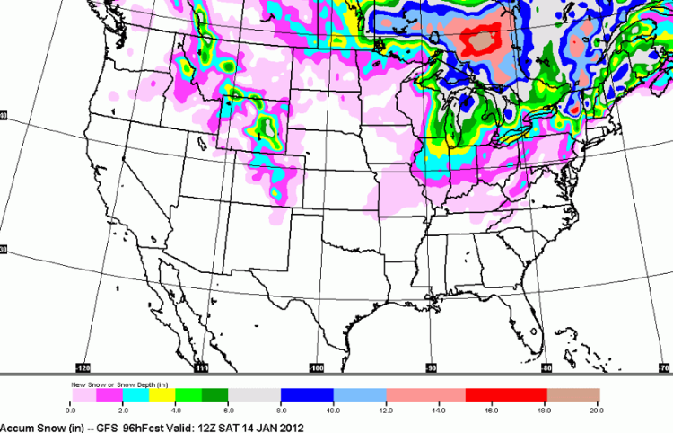
Precipitation amounts look to range around around half an inch in valley areas...closer to three quarters of an inch across some of the elevated terrain.

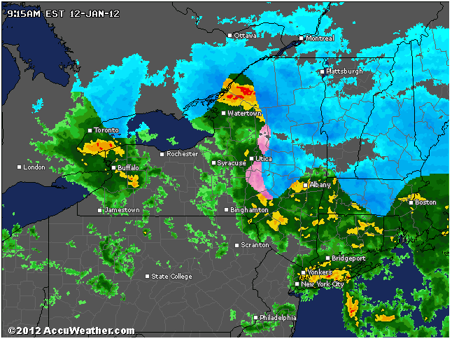
Precipitation types still remain somewhat uncertain. the 12z nam and ecmwf soundings continue to indicate mostly frozen precipitation would fall from albany northward...and a wintery mix further south transitioning to a cold rain.

The gfs is somewhat warmer...indicating the only place precipitation remains all frozen before it tapers to drizzle later on thursday...would be well north of albany while the areas around the capital district would see a winter mix transitioning to a cold rain...and mostly rain south.

For now...we followed a blend of the gfs and nam models and came up with a solution probably still leaning slightly with the warmer gfs since the trend this winter has been for systems to be warmer (unlike last year when they were colder).

Also...the high pressure is not in the perfect position to completely block colder air from getting in (at least aloft). we also went with a met/mav blend trending a touch more with the colder met output.

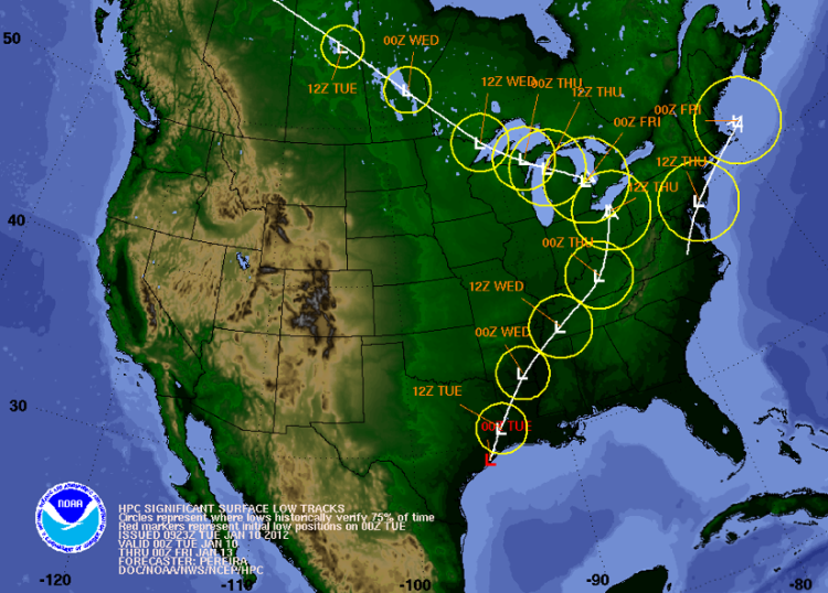
This storm system will not phase with our area in the middle of two areas of low pressure. models are in good agreement on the track of the southern steam system which looks to be much closer to our region tracking over or near the eastern tip of long island early thursday afternoon while the northern stream system drifts from the central great lakes towards the eastern great lakes.

When it is said and done late thursday expect sloppy sleet and snow accumulations of 1-4 inches in many valley areas...with the mid hudson valley and lower litchfield looking at a coating to an inch. across the higher terrain especially north of albany...4-7 inches of snow mixed with a little sleet looks to be a good bet from this
vantage point.
"You just need to go at that shit wide open, hang on, and own it." —Camp
Reply | Threaded
Open this post in threaded view
|

Re: Storm Speculation: 1/12/12

ausable skier
given everything I'd take 4-7 inches of wet slop over more rain 10 times out of 10
A true measure of a person's intelligence is how much they agree with you.
Reply | Threaded
Open this post in threaded view
|

Re: Storm Speculation: 1/12/12

Snowballs
Banned User
This post was updated on .
I think it's finally going to snow. Yesterday @ Gore it was sunny. Today, the sun tried and tried to emerge but dark, and then even darker clouds ,roiling up and gusting wind, completely blocked the sun. They were very dark and threatening by day's end. It simply felt and looked like winter storm is approaching. There'll be enough cold from the northwest to make it snow this time.
Reply | Threaded
Open this post in threaded view
|

Re: Storm Speculation: 1/12/12

Adk Jeff
Snowballs you may be correct.  Here's the most encouraging weather update that I've seen all winter:
The plot thickens.... FOR SNOW!!!!
Reply | Threaded
Open this post in threaded view
|

Re: Storm Speculation: 1/12/12

sudsnbumps
This is going to be a tough one...and you can look at all the different weather models, but this one will be up in the air until it happens.  The good news is that is is definitely a change in the weather pattern.  It's almost playing out exactly like the winter of 2006/2007.  Winter really began Martin Luther King Day and the snow lasted until May, with three big storms.  It is funny that with so many weather models, you can tell the forecasters who like snow and who don't on whether they lean toward a warmer solution or colder...Regardless I have Thursday and Friday available for powder days.
Proud to call Gore My Home Mountain
Covid stole what would have been my longest season ever!
I'll be back
Reply | Threaded
Open this post in threaded view
|

Re: Storm Speculation: 1/12/12

Harvey
Administrator
Winter Weather Advisories (purple) and Winter Storm Watches (blue) are up:

"You just need to go at that shit wide open, hang on, and own it." —Camp
Reply | Threaded
Open this post in threaded view
|

Re: Storm Speculation: 1/12/12

endoftheline
Darrin at adkwethersite has some hope for snow, check it out.
Reply | Threaded
Open this post in threaded view
|

Re: Storm Speculation: 1/12/12

jimvdak
Harv..love that winter weather warning map..all clear for my drive up 95 to my friend's in RI, then SNOW in New England where we're heading Friday! lol
*~It is better to go skiing and think of God, than go to church and think of sport.~*  -Fridtjof Nansen
Reply | Threaded
Open this post in threaded view
|

Re: Storm Speculation: 1/12/12

JasonWx
the NAM is much warmer on 12z ..waiting on GFS..NAM has mixed rain/snow for everyone...lets hope the GFS is colder
"Peace and Love"
Reply | Threaded
Open this post in threaded view
|

Re: Storm Speculation: 1/12/12

ScottyJack
I feeling confident this maybe an all snow event for the higher elevations of the Adirondacks!  Could be the first chance of the season to venture onto BC slides!!  
I ride with Crazy Horse!
Reply | Threaded
Open this post in threaded view
|

Re: Storm Speculation: 1/12/12

Raymo40
Holly Crap it accually snowed here in Ballson Spa. About 4 wet inches. Anything is better than nothing.
Reply | Threaded
Open this post in threaded view
|

Re: Storm Speculation: 1/12/12

ScottyJack
Snowing in Essex Ctny.  Started @ WF about 30 minutes ago.

I ride with Crazy Horse!
Reply | Threaded
Open this post in threaded view
|

Re: Storm Speculation: 1/12/12

Adk Keith


That's what I'm talking about!!

Igerna Hermit Cam
Reply | Threaded
Open this post in threaded view
|

Re: Storm Speculation: 1/12/12

Harvey
Administrator
Nice! Thanks for the pic.  Wanted to save a screencap of this morning:


May add some more later.
"You just need to go at that shit wide open, hang on, and own it." —Camp
Reply | Threaded
Open this post in threaded view
|

Re: Storm Speculation: 1/12/12

warp daddy
Unfortunately  we're  getting a Very bad Ice storm along the St Lawrence . About 1/2 inch so far , every school closed , roads r terrible and will be till early am.

Worst winter i've  experienced except the Great Ice Storm of 1998 ,when some up here were w/o power for 2-3 weeks.

Any significant icing here makes folks very concerned
Life ain't a dress rehearsal: Spread enthusiasm , avoid negative nuts.
Reply | Threaded
Open this post in threaded view
|

Re: Storm Speculation: 1/12/12

ausable skier
snowing hard here near WF - no rain happened first like they said
A true measure of a person's intelligence is how much they agree with you.
123