Storm Speculation: 2/13/14
1234
1234
|
Administrator
|
From NWS Albany this afternoon:
Thu-thu nt... The model trends seem to be further n/w with the overall sfc development and resultant qpf with the upcoming potential event for thu-thu nt. The 12z/10 ecmwf remains extremely consistent from run to run...Maintaining a track further w...Which would have potentially significant impacts on much of eastern nys and western new england with regard to possible snowfall. The 12z/10 gfs and gefs remain farther s/e...Although have trended a bit further n and w than previous runs. At this time...Confidence has risen slightly in the occurrence for at least a moderate snowfall for areas s and e of albany...But there also still remains at least some possibility for a much more widespread...Moderate to even heavy snow across the region...And would not be the least bit surprised to see model trends farther n and w over the next 24-36 hours. It appears that two main pieces of energy will be involved with this storm system...One currently translating across the sw us...And another piece ejecting from the pacific nw region. Both these pieces of upper level energy should become even better sampled tonight and tomorrow...So hopefully deterministic and ensemble guidance will begin to converge better on the potential storm/s overall track and evolution. Thermal profiles suggest mainly snow...Although can not rule out some mixing across far se areas should the track be further n and w.
"You just need to go at that shit wide open, hang on, and own it." —Camp
|
|
Hey Harv you wrote all that..pretty cool
 As of now this one looks like a i95 type storm..but many more runs to go... just saw the NWS heading..oh well
"Peace and Love"
|
|
Here's the latest from NWS...you gotta love the guess factor...I hope the Euro is right

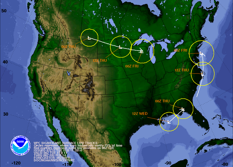
for Albany coverage area... INTERESTINGLY...WHILE CONFIDENCE IN THE TRACK OF THE STORM HAS INCREASED...THE TIMING OF THE STORM AND ITS ULTIMATE QPF REMAIN IN DOUBT. IT LOOKS AS IF THE LOW WILL TRACK OFF CAPE HATTERAS WEDNESDAY EVENING...AND BE TO THE EAST OF THE DELMARVA PENINSULA THURSDAY MORNING...AND TRACK TO THE EAST OF CAPE COD EITHER THURSDAY NIGHT OR PERHAPS NOT UNTIL FRIDAY MORNING. THE 00Z EUROPEAN FORECAST MODEL (ECMWF) TRACKS THE STORM A LITTLE FURTHER WEST WITH MUCH STRONGER DYNAMICS ALOFT (A POTENT UPPER AIR LOW CLOSING OFF). IT HAS BEEN FAIRLY CONSISTENT WITH THIS SCENARIO FOR SEVERAL RUNS. THE QPF FROM THIS MODEL WOULD GENERATE A SIGNIFICANT SNOWSTORM ACROSS MOST IF NOT ALL OUR REGION...WITH MUCH OF THE SNOW FALLING THURSDAY NIGHT.
Proud to call Gore My Home Mountain
Covid stole what would have been my longest season ever! I'll be back |
|
so do I..but at this time it is the outlier..
"Peace and Love"
|
|
wiggle it, just a little bit left. WIGGLE IT! That's the mind control I'm vibing this week! Wiggle to the left, just a little bit!!!!
I ride with Crazy Horse!
|
|
http://www.famousinternetskiers.com/presidents-weekend-weather-forecast/
I ride with Crazy Horse!
|
|
who's gonna woot woot for a wiggle!!!!!
WOOT WOOT!!! 
I ride with Crazy Horse!
|
|
Administrator
|
The precip and point forecasts seem to show the storm staying our of the Daks and dropping a little something in the Cats.
But if this map were to verify it would seem to indicate more snow inland? 
"You just need to go at that shit wide open, hang on, and own it." —Camp
|
|
In reply to this post by ScottyJack
It might have wiggled a little. Although they'll have more to say in about an hour, here's NWS BTV's synopsis from about a 1/2 hour ago:
OUTSIDE A FEW FLURRIES THIS MORNING...STRONG HIGH PRESSURE WILL BRING COLD AND DRY WEATHER TO THE REGION TODAY INTO WEDNESDAY. A DEVELOPING STORM SYSTEM WILL PASS OFF THE NEW ENGLAND COAST BY LATER THURSDAY INTO FRIDAY MORNING SPREADING AN ACCUMULATING SNOWFALL TO EASTERN NEW YORK AND INTO VERMONT. SNOW SHOWERS PERSIST FOR FRIDAY INTO SATURDAY BEFORE FAIR AND DRY WEATHER RETURNS BY EARLY NEXT WEEK. The mention of "accumulating" snow in "eastern NY" make me think the Euro may have won this argument - at least at this point. Hope springs eternal. |
|
This post was updated on .
In reply to this post by Harvey
I think you're right. That coastal low looks like it's well inside the benchmark. |
|
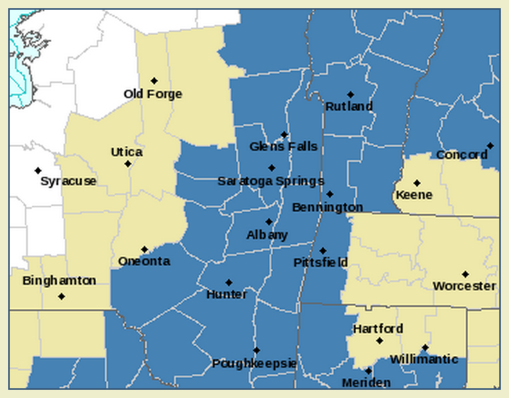
Storm watch just went up. Potential of 7 or more inches. No specifics on where in the area exactly what is going to fall. Early for a storm watch starting on Thursday?
http://forecast.weather.gov/showsigwx.php?warnzone=NYZ042&warncounty=NYC113&firewxzone=NYZ042&local_place1=&product1=Winter+Storm+Watch#.UvqCZjYo4u4 |
|
Administrator
|
Watches:

"You just need to go at that shit wide open, hang on, and own it." —Camp
|
|
In reply to this post by Danzilla
there's a fairly sharp cut off with the qpf..the dacks are bit to far north and west..still lots of time to go
"Peace and Love"
|
|
In reply to this post by JasonWx
BASED ON WATER VAPOR
PRESENTATION...SYSTEM ACRS THE NW CONUS IS VERY IMPRESSIVE WITH GOOD MOISTURE FLUX AND POTENT S/W ENERGY...WHICH SEEMS TO HAVE INITIALIZED WELL WITH THE GEM/UKMET/ECMWF THE BEST. NAM/GFS CONT TO SHOW THE ENERGY WEAKENING ACRS THE INTER MOUNTAIN WEST...THEN REDEVELOPING OVER THE SE CONUS. THIS RESULTS IN A SLOWER INTENSIFICATION OF SFC LOW PRES AND WEAKER OVERALL SYSTEM WITH 5H/7H CIRCULATIONS NOT CLOSING OFF UNTIL THE MID ATLANTIC COAST. GFS IS TRENDING TWD THE GEM/UKMET/ECMWF MODELS BY SHOWING QUICKER SFC LOW PRES DEVELOPMENT AND TRENDING SLIGHTLY CLOSER TO THE COAST WITH 977MB LOW PRES NEAR CAPE COD BY 06Z FRIDAY. FEEL NAM WL JUMP ON BOARD WITHIN THE NEXT COUPLE OF RUNS...ESPECIALLY AS SYSTEM EJECTS FROM INTER MOUNTAIN WEST INTO THE SE CONUS. Woot, woot....wiggle wiggle? We like the GEM/UKMET/ECMWF on this one....and it's starting to not look like an outlier any more. |
|
The Euro has been the most consistent this winter...but we won't know for sure until it happens. Prayers, Vibes, Woot Woot Wiggle Wiggle...what ever works

Proud to call Gore My Home Mountain
Covid stole what would have been my longest season ever! I'll be back |
|
This post was updated on .
When you say "woot woot" it makes Baby Jesus cry. It also makes low pressure systems on the east coast of the North American continent hook to the east. That's just basic meteorology. So don't say "woot woot".
|
When this one happens NJ has to say woot woot whenever prompted on Sunday!
I ride with Crazy Horse!
|
|
woot wiggle woot POW POW!

I ride with Crazy Horse!
|
|
In reply to this post by ScottyJack
Why not Saturday? What's so special about Sunday? |
«
Return to Weather Archive
|
1 view|%1 views

