Gore Website Suggestion
1234
1234
|
I just thought of this, and I tried, without luck, to search for a similar suggestion.
You know the paper ski patrol report that they post all over the lodge in the morning? I look for it right away when I get to the lodge. Wherever they print it, they can also scan it and post a .pdf of it on the website and even post updates as they happen during the day. Again, excuse me if this has already been suggested.
"They don't think it be like it is, but it do." Oscar Gamble
|
|
Administrator
|
Good idea.
Not really a website suggestion but I'd like to see that sheet ready to go for first tracks.
"You just need to go at that shit wide open, hang on, and own it." —Camp
|
Why does this even need to be suggested? |
|
In reply to this post by Harvey
...what is even a better idea, is Gore actually formulating a "real time" trail report based on the actual conditions that day as opposed to looking in a crystal ball and releasing the report the day before at 3pm...

Gotta go to know
|
You ask for too much! |
|
Gore unfortunately has the worst snow phone in the industry too. What's odd is that ORDA does a great job with Whiteface, which I think has one of the best.
|
|
In reply to this post by Spongeworthy
An updated report during the day would be really helpful. Learning that a previously closed lift is now spinning without having to see it for yourself would be great. Also they could provide an announcement when twister is open to the public so that it's easier to get to burnt ridge. tom |
|
I believe that Gore faxes that form to Inside Edge in Queensbury, so why can't they put in on their website?
And we all agree that the ski report on the telephone is the worst 
"They don't think it be like it is, but it do." Oscar Gamble
|
|
Any idea if and when they will launch the new site? Also, has anyone seen the new 2014 trail map yet with the new glades and trails shown?
|
|
Administrator
|
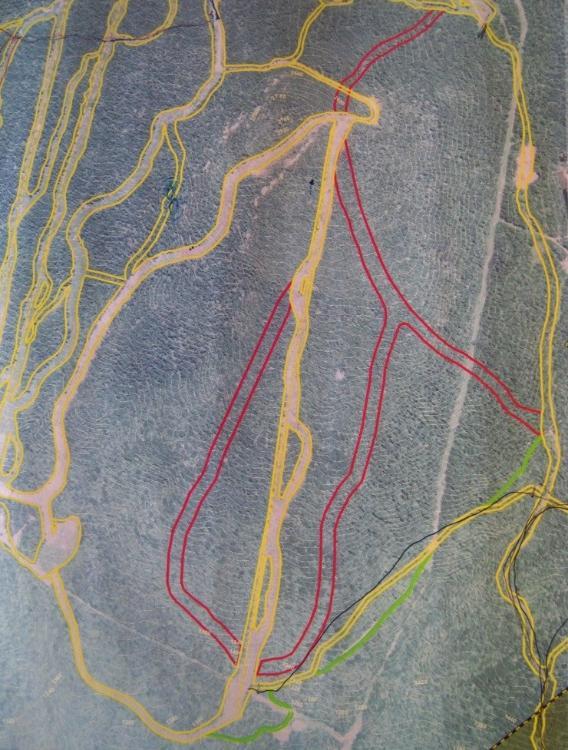
The only thing I see in the new map is the north chair cut over:
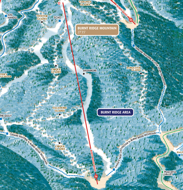
 Got me thinking though... I wonder if the reasoning behind Boreas is to put another glade in between two trails Sagamore and Barkeater.  Gulp. There is some symmetry there.
"You just need to go at that shit wide open, hang on, and own it." —Camp
|
|
Harv,
Correct me if I'm wrong but I believe that's last year's trail map still. If you look at the URL it's says. 2012 trail map. |
|
This post was updated on .
In reply to this post by Harvey
I couldn't figure out what you were talking about, but then I realized that you were suggesting that they might clear cut Barkeater and make it into a normal trail. I actually don't have any issue with that at all (besides the additional strain on the acreage limit). I like Barkeater, but I'm not going to go to bat for it. Especially if it means that I can have a way to get to the skibowl without doing pipeline (being low elevation and popular, Barkeater gets skied off pretty quickly and isn't really reliable in low snow years). The ideal situation is to clear cut a trail directly next to Barkeater that has snowmaking. Then the snowmaking would bleed into the glade increasing base depth, there would be an easy way for intermediates to get to the skibowl, and all of the hard work in cutting the trail wouldn't have been for naught. Either way, I don't feel like that's something that's going to happen in the immediate future. |
|
Administrator
|
This post was updated on .
I think agree that it probably make sense to cut Barkeater as a trail. You've got that fancy lift over there, and while I like the idea of more trees...
I also agree that it probably won't happen soon as that is a looong piece of pipe, and the priorities for big capital are the Adk Express and the High Peaks chair. I do think it will happen eventually. Barkeater is actually approved as a trail on the UMP and it is within the 40 mile limit. 
"You just need to go at that shit wide open, hang on, and own it." —Camp
|
|
niice!
gotta love stealth mode camera work.
The long days of Shockley are gone,
So is football Kennedy style |
|
In my opinion, Gore has been exceedly clever in expanding its terrain by using glades - a fantastic example of good lawyering. As most of you know, there is a trail mileage limit in place for Gore. What many people do not realize is that raising that limit requires a constitutional amendment. That's quite a hurdle to overcome. If you look at some of the "glades" Gore has put on the map, many of them really just trails with a few trees. Double Barrel is a pefect example. I see no reason that Gore couldn't cut a normal trail, but leave a few trees spaced out all over it and call it a glade. Courts tend to give deference to an administrative agency in interpreting its own organic statute (or in this case, the constitutional provision regarding Gore's trail count). I think as long as it passes the laugh test, ORDA's got a pretty free hand in cutting additional "glades."
|
|
In reply to this post by CUontheslopes131
A copy of the updated map went out in a mailer that we received at home earlier this week. It shows the Hedges reconfiguration (splitting Tahawus Glade into an Upper and a Lower), the two new Ski Bowl glades and Boreas. I'd imagine it won't be long before the website map is updated too. |
|
This post was updated on .
In reply to this post by CUontheslopes131
CONTENTS DELETED
The author has deleted this message.
There's truth that lives
And truth that dies I don't know which So never mind - Leonard Cohen |
SSSSSSSHHHHHHHH! |
|
In reply to this post by Harvey
Okay, then! Let's do it. And, while they're at it, they should cut that trail that goes to the old Gondy midstation, then goes to the Topridge chair. That would open up some REALLY fun lines. |
|
Administrator
|
I believe that will happen too. Some may not like that a la Burnt Ridge. Double Barrel has no snowmaking or grooming and hasn't been graded. Looks like the grooming is "the decider" since there are some other trails without gun pow.
"You just need to go at that shit wide open, hang on, and own it." —Camp
|
«
Return to Woodstove Archive
|
1 view|%1 views

