Storm Speculation: 11/27/13
123
123
|
Administrator
|
This post was updated on .
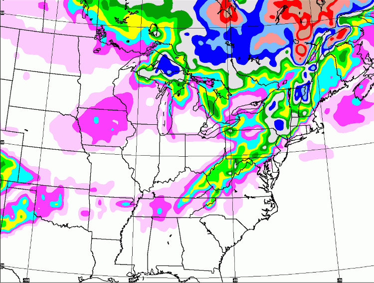
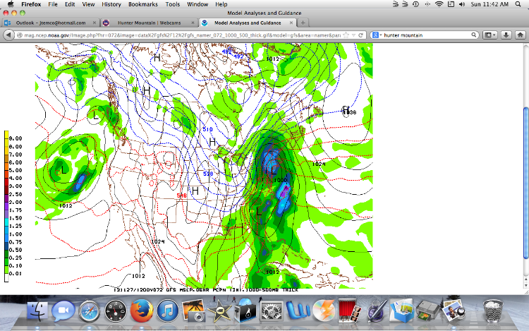
Jason, Suds and Weather Geeks... The GFS is onto something next week. Not sure it is going to be pushed to the south of what.
 NWS ALB doesn't seem too excited: TUESDAY NIGHT THROUGH WEDNESDAY NIGHT...FOR NOW WILL KEEP CHANCE POPS IN THE FORECAST AS A LOW PRESSURE SYSTEM TRIES TO WORK ALONG THE FRONTAL BOUNDARY TO OUR SOUTH AND MAY PASS CLOSE ENOUGH TO PRODUCE AT LEAST SOME LIGHT PCPN ACROSS OUR REGION. THE GEFS PLUME DIAGRAM HAS MOST MEMBERS WITH LITTLE IF ANY PCPN FOR KALB BUT A FEW MEMBERS SHOW CONSIDERABLE QPF AND MUCH OF IT AS SNOW. THE SURFACE LOW TRACK ON THE GFS WOULD GIVE PCPN TO THE SRN TWO THIRDS OF THE FA WITH SOME OF THE PCPN IN THE FORM OF SNOW ESPECIALLY AS THE LOW PULLS NORTHEAST INTO THE GULF OF MAINE WRAPPING THE COLD AIR BACK ACRS OUR REGION. THE GGEM HAS A TRACK EVEN CLOSER TO THE COAST GIVING BULK OF FA RAIN WITH SNOW CONFINED PRIMARILY TO THE ADIRONDACKS. THE ECMWF WOULD INITIALLY FAVOR RAIN CLOSER TO THE COAST AND SNOW FOR AREAS FROM KALB NORTH AND WEST WITH A CHANGE OVER TO ALL SNOW AS THE LOW LIFTS INTO THE GULF OF MAINE. IN LOOKING AT THE SURFACE LOW TRACKS OF THE GFS/GGEM AND ECMWF THE GGEM APPEARS THE QUICKEST AND CLOSEST TO THE COAST WITH THE ECMWF HINTING AT A DOUBLE LOW STRUCTURE WHICH MAY RESULT IN A MORE PROLONGED EVENT. Let me know if you guys think this is worth a storm speculation thread and I will separate this out.
"You just need to go at that shit wide open, hang on, and own it." —Camp
|
|
I'd wait for Sunday's Oz and see if it's still there. I hate the let down after a hyped event ends up in Maryland or out in the middle of the ocean. I know the urge to model hug this time of year though; Been there, done that.
|
|
I don't trust any of the models beyond 72hrs..their long range performance has been hideous .
"Peace and Love"
|
|
Looks promising, but it is too soon to tell. Overall, winter seems to be starting early this year, about 2-3 weeks ahead of where we were the last 2 years, and this is very encouraging.
|
|
Administrator
|
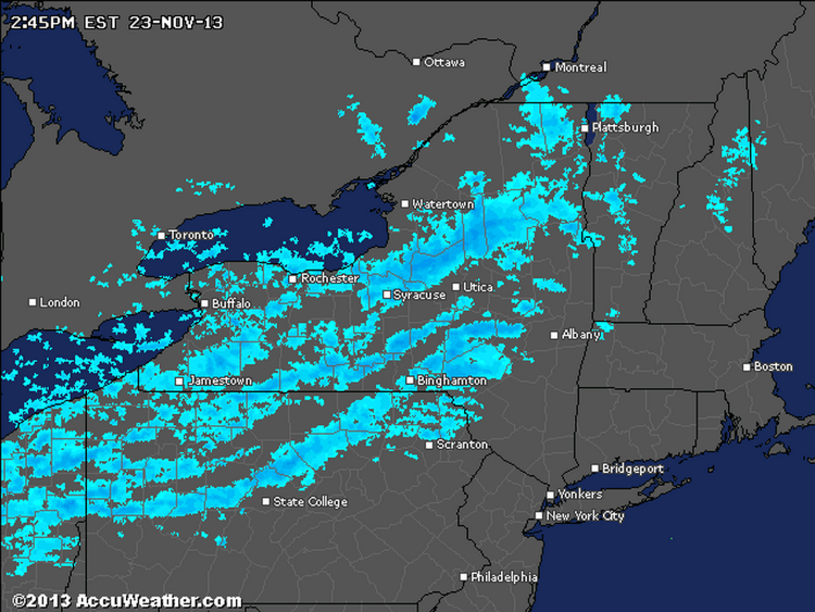
Nice snowfall going at this moment.

"You just need to go at that shit wide open, hang on, and own it." —Camp
|
|
Cold front from Canada = lake effect. You're welcome.
Love Jay Peak? Hate Jay Peak? You might enjoy this: The Real Jay Peak Snow Report
|
|
Administrator
|
What do you think Noah? This is NWS ALB tonight:
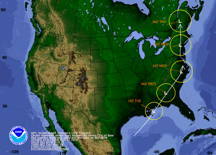
BY TUESDAY... THE WELL ADVERTISED POTENTIAL STORM BEGINS TO ORGANIZE IN THE SOUTHERN U.S. AND THE VARIOUS SETS OF GUIDANCE ARE SHOWING MORE SPREAD THAN USUAL...LEADING TO A LOWER CONFIDENCE ON THE POTENTIAL TRACK OF THE STORM. DURING THE EARLY STAGES OF THE DEVELOPMENT TUESDAY...SOME INITIAL NORTHERN STREAM UPPER ENERGY COULD INTERACT WITH THE LEADING EDGE OF WARM ADVECTION ASSOCIATED WITH THE DISTANT SOUTHERN STREAM ENERGY...RESULTING IN THICKENING CLOUDS AND POSSIBLE ONSET OF RAIN AND/OR SNOW BY LATE AFTERNOON. HIGHS TUESDAY AROUND 40 TO LOWER 40S...30S IN NORTHERN AREAS. LONG TERM ... TUESDAY NIGHT THROUGH SATURDAY... THE PERIOD STARTS OUT TUESDAY NIGHT WITH OUR REGION POTENTIALLY STARTING TO BE IMPACTED BY A SIGNIFICANT COASTAL STORM. THERE IS INCREASING CONFIDENCE FOR LIKELY PRECIPITATION FROM A DEVELOPING LOW PRESSURE SYSTEM WITH ABUNDANT MOISTURE MOVING NORTHWARD ALONG THE COASTAL PLAIN OR JUST OFF THE EASTERN SEABOARD TUESDAY NIGHT INTO WEDNESDAY. THE 12Z ECMWF/GGEM AND GFS ENSEMBLES INDICATE MORE OF A WESTWARD TREND IN THE TRACK OF THIS POTENTIAL SYSTEM. THE OPERATIONAL GFS CONTINUES TO BE AN OUTLIER SHOWING A TRACK WELL OFF SHORE.
"You just need to go at that shit wide open, hang on, and own it." —Camp
|
|
Administrator
|
In reply to this post by Sick Bird Rider
Lake effect that makes it to Gore is some pretty special chit. Keep er comin.
"You just need to go at that shit wide open, hang on, and own it." —Camp
|
|
The engine is on - coldest night of the new winter season so far. From the Hinterlandian weather people:
Tonight, 23 November Mainly cloudy with 60 percent chance of flurries. Wind northwest 30 km/h gusting to 50. Low minus 16. Wind chill minus 26 this evening. That's all in metric. Sorry, no translation. Pretty effing cold for November.
Love Jay Peak? Hate Jay Peak? You might enjoy this: The Real Jay Peak Snow Report
|
|
Albany got a dusting, nothing is Saratoga. Plow trucks were out on my drive home tonight.
|
|
Harv, BTV's talking about an argument between the Euro and the GFS that still wasn't resolved with the latest model runs.
AS OF 640 AM EST SUNDAY...STILL CONSIDERABLE MODEL DIFFERENCES CONCERNING MOISTURE-LADEN SYNOPTIC LOW EXPECTED TO AFFECT THE NORTH COUNTRY TUESDAY NIGHT INTO WEDNESDAY...WHICH UNFORTUNATELY COINCIDES WITH ONE OF THE BUSIEST TRAVEL DAYS OF THE YEAR. THE 00Z NWP DIFFERENCES CONTINUE TO SURROUND INTERACTION BETWEEN VIGOROUS BUT DISTINCT NRN AND SRN STREAM SHORTWAVE TROUGHS AS SYSTEMS CROSS THE OHIO VALLEY AND SERN STATES...RESPECTIVELY. THE DEEPER AND MORE PHASED SOLN OFFERED BY THE 00Z ECMWF TAKES THE LOW INLAND UP THE EAST COAST AND ULTIMATELY TRACKS A 986MB LOW ACROSS VT BETWEEN 18Z WED AND 00Z THU. THIS IS A WARMER SOLN WITH 850MB TEMPS REACHING +8C ACROSS VT AT 18Z WEDNESDAY. ANY SNOW AT THE ONSET TUESDAY NIGHT WOULD SWITCH OVER TO MAINLY RAIN ACROSS THE REGION. MEANWHILE...THE 00Z GFS CONTINUES THAT MODEL/S TENDENCY TO KEEP A FASTER MOVING SYSTEM OFFSHORE BETWEEN THE 40N 70W BENCHMARK AND CAPE COD WITH A 994MB LOW MOVING THROUGH AT 18Z WEDNESDAY. THIS IS A MUCH COLDER SOLN...WITH POTENTIAL ACCUMULATING SNOW ACROSS VT AND LESS PRECIPITATION IMPACT FOR NRN NY. HAVE INCREASED POPS TO 70-80 PERCENT LATE TUESDAY THROUGH WEDNESDAY ASSOCIATED WITH THIS SYSTEM WITH QPF ON THE ORDER OF 1"...BUT IT REMAINS TOO SOON TO DETERMINE P-TYPE DETAILS GIVEN UNCERTAIN EVOLUTION/PHASING OF NRN AND SRN STREAMS. THOSE WITH TRAVEL PLANS WEDNESDAY SHOULD CONSIDER PROSPECT FOR WINTER TRAVEL CONDITIONS ACROSS THE NORTH COUNTRY...BUT THAT IS BY NO MEANS A SURE THING AT THIS POINT. WE/LL MAINTAIN MENTION OF THIS SYSTEM IN THE HAZARDOUS WEATHER OUTLOOK. Meanwhile, we did alright with the LE assisted clipper yesterday and last night (~5") but now the wind machine is cranked up. |
|
we all better hope the GFS is correct..
"Peace and Love"
|
|
the new GFS stabbed us in the back..we are screwed

"Peace and Love"
|
|
Screwed as in rain or just no snow?
if You French Fry when you should Pizza you are going to have a bad time
|
|
a total mixed bag for the Dacks and Greens..snow to sleet then rain back to snow. maybe some decent upslope..we will have to wait and see..
the models are very inconsistent..
"Peace and Love"
|
|
This post was updated on .
Upper elevation it's going to be all snow. This is good. I'm calling it now. Even if the snow/rain/snow thing happens, this is a base building event.
And, amazingly, this looks like one of those rare storms that NY makes out better than VT. Hutz is calling for a upslope rain/upslope snow line at the Northway - East of the Northway rain, west of the Northway snow. High Peaks and WF will have "significant snow". Nothing but good news here. C'mon Jason, I liked the new, optimistic you. Keep that going! |
|
Hi all - first time poster here, appreciate the updated weather reports:
With the current models calling for "ice pellets" in the catsills Tue/Wed, what mtns do you think are best bets for this Sat/Sun? Looking for smallest crowd/most open terrain (aren't we all) within 2-3 hrs of northern catskills. Thx!
2013/2014 Season:
Windham 11/30, 12/14, 1/24, 1/30, 2/1 Hunter 1/4 Killington 1/18, 1/19 Big White B.C 2/10, 2/11, 2/12, 2/13, 2/14, 2/15 |
|
Forecasts I listen to are calling for 8"+ through Tuesday night with ice in Wed, should be the perfect base builder storm for the Daks. I was planning to take leaves wed, that ain't happening
|
|
Administrator
|
This post was updated on .
 URGENT - WINTER WEATHER MESSAGE NATIONAL WEATHER SERVICE ALBANY NY 354 AM EST MON NOV 25 2013 THE NATIONAL WEATHER SERVICE IN ALBANY HAS ISSUED A WINTER STORM WATCH...WHICH IS IN EFFECT FROM TUESDAY AFTERNOON THROUGH WEDNESDAY EVENING. ...THE FIRST POSSIBLE WINTER STORM COULD CAUSE SIGNIFICANT HOLIDAY TRAFFIC PROBLEMS ACROSS THE SOUTHERN ADIRONDACKS AND WESTERN MOHAWK VALLEY. * LOCATIONS...THE SOUTHERN ADIRONDACKS AND WESTERN MOHAWK VALLEY. * HAZARD TYPES...A MIX OF SNOW...SLEET AND FREEZING RAIN. * ICE ACCUMULATIONS...UP TO HALF AN INCH OF ICE. * SNOW ACCUMULATIONS...3 TO 7 INCHES...MIXED WITH SLEET. * MAXIMUM SNOWFALL RATES...UP TO AN INCH PER HOUR. * TIMING...SNOW WILL DEVELOP BY LATE TUESDAY AFTERNOON...MIX WITH SLEET AND FREEZING RAIN AND POSSIBLY A PERIOD OF PLAIN RAIN TUESDAY NIGHT INTO EARLY WEDNESDAY. PRECIPITATION MIGHT BE HEAVY AT TIMES. MIXED PRECIPITATION WILL CHANGE BACK TO SNOW LATER ON WEDNESDAY.
"You just need to go at that shit wide open, hang on, and own it." —Camp
|
|
I like the sound of this, especially for November. Hopefully the rain is minimal- I'd personally rather it be cold and have little precip than have the chance for some snow, but temps in the 30s. The flatland forecast is calling for cold rain tomorrow night and Wednesday. Usually that's equals snow in the ADKs, but this storm seems to be a bit peculiar...
|
«
Return to Weather Archive
|
1 view|%1 views

