Storm Speculation: 12/22/12
1234
1234
|
Administrator
|
This post was updated on .
LOL. I know I'm the eternal optimist but I think Christmas week will be good for the NY/Northeast mountains. Now EVERYONE LISTEN UP - GET OUT AND SUPPORT THE TEAM! That means YOU ScottyJack. And the rest of youse.  
"You just need to go at that shit wide open, hang on, and own it." —Camp
|
|
20 " at Saddleback in Maine, but it's a long drive.
Avitar=Left Gully, Tuckerman Ravine
No Fat Chicks, Just Fat Skis |
|
BTV forecast discussion mentions possibility for 6" in upslope this weekend for higher elevations in dacks/greens! I'm guessing whiteface qualifies as higher elevation? They say 2-3" in the valleys.
ORDA and New England Passholder. If it's fast, it's probably fun.
2014-2015 season days Whiteface: 2 Sunday River: 4 Loon: 2 Hunter: 1 Belleayre: 1 |
|
In reply to this post by Harvey
The lack of snow is not because we're not "supporting the team" . . . It's because it's freaking December 19th and it's still not even winter (technically). Plenty of season left. Not to say I'm not ready for some snow. Contemplated driving to Maine last night (total storm accumulation looked to be around 3 feet at Sugarloaf - that qualifies as epic). |
Plus I've never skied at Saddleback. :P Unfortunately I have yet to have started my shopping which includes a couple of pair of skis for one daughter.
Ski Mad World
A blog of MadPat's World: A History of Skiing Geography |
|
Administrator
|
In reply to this post by MC2 5678F589
MC... that was a late night, not super well thought out post. I'd just spoken to Laz who's struggling to get his mtn open. At the time he'd told me that if it was cold enough he was hoping to get Face open (the triple) T2B. (Now he's shooting for the 26th). At the time I was hoping that Cats skiers would show up this weekend. Not sure why I singled out Scotty, that was just crazy talk.
I'm one to talk, I've barely been out this year. I think it's affecting my well being. Hope to ski with you soon. PS that map is on crack, but it made me smile when I saw it.
"You just need to go at that shit wide open, hang on, and own it." —Camp
|
|
Definitely. I'm not flaming you or anything. I'm just saying, patience, grasshopper.
I seem to be the only calm one every year around this time. For instance last year, I said on December 28th: So . . Ummm . . . What point was I trying to make again? |
|
Administrator
|
This post was updated on .
LOL.
I'm really not sweating the weather. (I do think about Laz and Danielle a lot.) Read my posts, I never stress the weather anymore. Life is get pretty heady and I just hope to ski a few scrappy groomer runs so I can forget about it for a few minutes. If any one has any idea about how we can get a bunch of people out to Platty, start a thread. The Diamond in Brooklyn wants to do a day on 1/26, but I'd like to do something before that if poss. If we could get a big group, and we bought a bunch of beers, maybe we could get a deal. Back on topic, more from Darrin: http://www.ilsnow.com/2012/12/19/one-two-punch-friday-and-saturday/
"You just need to go at that shit wide open, hang on, and own it." —Camp
|
|
Global warming sucks. I'm beginning to think we''ll never see another winter like 2 years ago...
|
|
Administrator
|
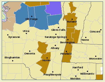
Winter Storm Watch for So Adk:
 NORTHERN HERKIMER-HAMILTON-NORTHERN WARREN- INCLUDING THE CITIES OF...ATWELL...BIG MOOSE...EAGLE BAY... MCKEEVER...NOBLEBORO...NORTHWOOD...OLD FORGE...SPECULATOR... WARRENSBURG 419 AM EST THU DEC 20 2012 ...WINTER STORM WATCH IN EFFECT FROM THIS EVENING THROUGH FRIDAY MORNING... THE NATIONAL WEATHER SERVICE IN ALBANY HAS ISSUED A WINTER STORM WATCH...WHICH IS IN EFFECT FROM THIS EVENING THROUGH FRIDAY MORNING FOR THE SOUTHERN ADIRONDACKS. * LOCATIONS...SOUTHERN ADIRONDACKS * HAZARD TYPES...A COMBINATION OF SNOW...SLEET AND WIND. * SNOW ACCUMULATIONS...6 TO 9 INCHES...MIXED WITH SLEET. * MAXIMUM SNOWFALL RATES...AN INCH PER HOUR. * TIMING...SNOW ARRIVING THIS EVENING....CONTINUING INTO FRIDAY MORNING WHEN IT WILL BECOME MIXED WITH RAIN. * IMPACTS...SNOW COULD CAUSE VERY TREACHEROUS TRAVEL. ALSO...THE COMBINATION OF WET SNOW...SLEET AND WIND COULD RESULT IN SCATTERED POWER OUTAGES. * WINDS...SOUTHEAST 15 TO 25 MPH WITH GUSTS 30 MPH...POSSIBLY UP TO 50 MPH. * TEMPERATURES...AROUND 30 DEGREES.
"You just need to go at that shit wide open, hang on, and own it." —Camp
|
|
Snow finally snow.
Scotty
|
|
This is not the pessimistic me , it is the realistic me..
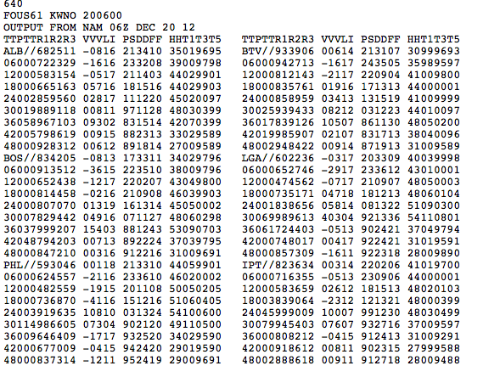
tonight's event will start as snow, but it will change to rain, all the way to the Canadian border  This the 06z nam fous.. fellow weather weenies will understand it..it ain't pretty
"Peace and Love"
|
I remember the last time you said that.  (okay, I'm not in NY) (okay, I'm not in NY)
I'm just bummed that there is almost one way I can go skiing tomorrow. Night skiing...maybe? Saturday? - Snow day is going to F* up my youngest daughter's Christmas Show at her school. - Wife has an important followup appointment for one of our cats. - Car is way overdue for service.
Ski Mad World
A blog of MadPat's World: A History of Skiing Geography |
|
At this point at least give us some cold air to freeze up the lakes/ponds.
I'm ready for ice racing, pond hockey, and fishing
The day begins... Your mountain awaits.
|
|
In reply to this post by MadPatSki
I remember the last time you said that. (okay, I'm not in NY)
<quote author="MadPatSki"> <quote author="JasonWx"> Touche
"Peace and Love"
|
|
In reply to this post by JasonWx
The weather service report that Harv just posted said 6 to 9 inches of snow. If it does that, and then rains on top of it for a little while, and then there's a hard freeze (like it looks to be on Sunday), wouldn't that be a pretty good 1st layer in the woods? I mean, it's one thing to be pessimistic, it's another to never see the bright side of anything ever . . . |
|
Lionel calling for 10-16 by Monday night with a 30% of 24 in the higher elevation of ADKs. I'm going w/ Lionel. he's always right!!
I ride with Crazy Horse!
|
|
In reply to this post by MC2 5678F589
I'm pretty stoked...just...need...to...find...the...time!!!
Ski Mad World
A blog of MadPat's World: A History of Skiing Geography |
|
From Darrin @ http://www.ilsnow.com/weather/
"Thursday Night: Snow arriving by midnight will mix with sleet at times overnight. Low 27-32. Friday: Mixed sleet and snow will change to snow south and east of Raquette Lake in the morning, but turn to rain around Inlet and Old Forge. Snow may become heavy at times around Indian Lake and Speculator before changing to rain by noon. Rain will change back to snow during the afternoon. High 33-38. Total snow accumulation from Thursday Night through Friday afternoon: 4-8 inches around Indian Lake and Speculator, 8-12 inches over Moose River Plains but snow amounts will decrease rapidly to 2-4 inches enroute to Inlet and Old Forge."
The day begins... Your mountain awaits.
|
|
This post was updated on .
PEACE AND LOVE ...PEACE AND LOVE
first of all in never said it wasn't going to snow, i said it was going to start as rain . then lake effect would take over along with orographic snows. here's the latest from NWS ALB...i guess they're pessimists too THE LATEST THERMAL PROFILES HAVE TRENDED WARMER WITH THE GFS AND NAM WITH THE MAIN PTYPE FOR MOST OF THE FCST AREA BEING RAIN...EXCEPT FOR THE SRN DACKS REGION. THE COLUMN IS EXPECTED TO COOL RAPIDLY...WITH SNOW BREAKING OUT OVER THE SRN DACKS...AND POSSIBLE THE GREENS. WE BELIEVE THE E/SE FLOW WILL BANK IN SOME COLD AIR OVER NRN FULTON COUNTY /WITH DYNAMICAL COOLING/...FOR SEVERAL INCHES POSSIBLE IN A SHORT DURATION. A WINTER WX ADVISORY FOR SNOW AND WIND HAS BEEN ISSUED FOR NRN HERKIMER...HAMILTON...NRN WARREN...AND NRN FULTON COUNTIES. EXPECT SOME SNOW ACCUMULATIONS OF 3 TO 7 INCHES BY 12Z OR SO. MUCH LIGHTER AMOUNTS OF COATING TO LESS THAN AN INCH WILL BE POSSIBLE OVER THE SRN GREENS...CATSKILLS...AND BERKS. THE NEXT CHALLENGE IS FOR A NARROW COLD FRONTAL RAINBAND WITH EMBEDDED CONVECTION. THE 12Z NAM HAS SHOWALTER VALUES FALLING TO O TO -1C OR SO OVER THE SRN 3 COUNTIES FOR THE FCST AREA. WE ADDED A SLIGHT CHC OF THUNDER TO DUTCHESS...LITCHFIELD...AND ULSTER COUNTIES. PERIODS OF MODERATE TO PERHAPS HEAVY RAINFALL WILL BE POSSIBLE ESPECIALLY SOUTH OF THE CAPITAL REGION BTWN 06Z-12Z. SEE THE HYDRO SECTION FOR MORE DETAILS. LOW TEMPS WILL BE OF THE WET BULB VARIETY...AND THEN BOUNCE UPWARD. EXPECT MINS IN THE U20S TO U30S. PEACE AND LOVE ...PEACE AND LOVE..
"Peace and Love"
|
«
Return to Weather Archive
|
1 view|%1 views

