Storm Speculation: 12/28/12
123
123
|
Administrator
|
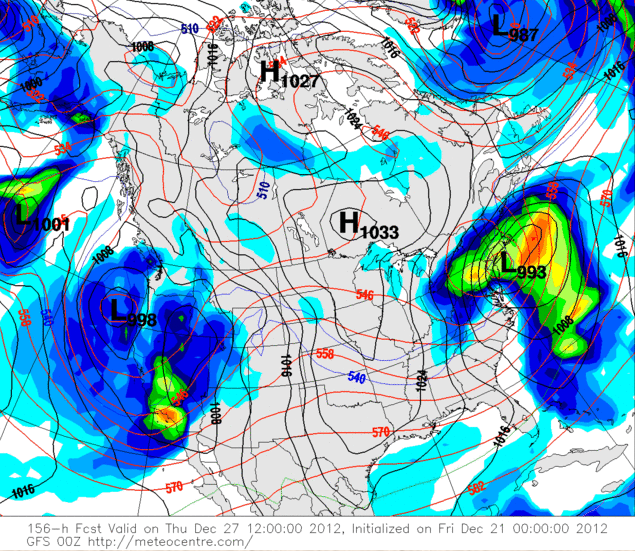
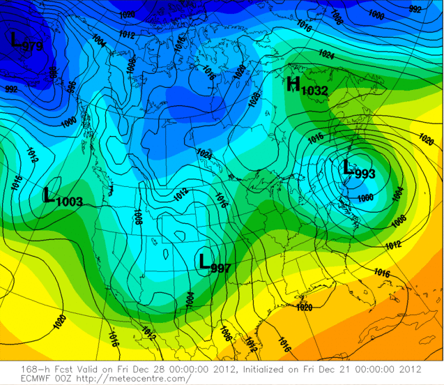
GFS and Euro are both indicating that something might be brewing towards the end of next week...
 
"You just need to go at that shit wide open, hang on, and own it." —Camp
|
|
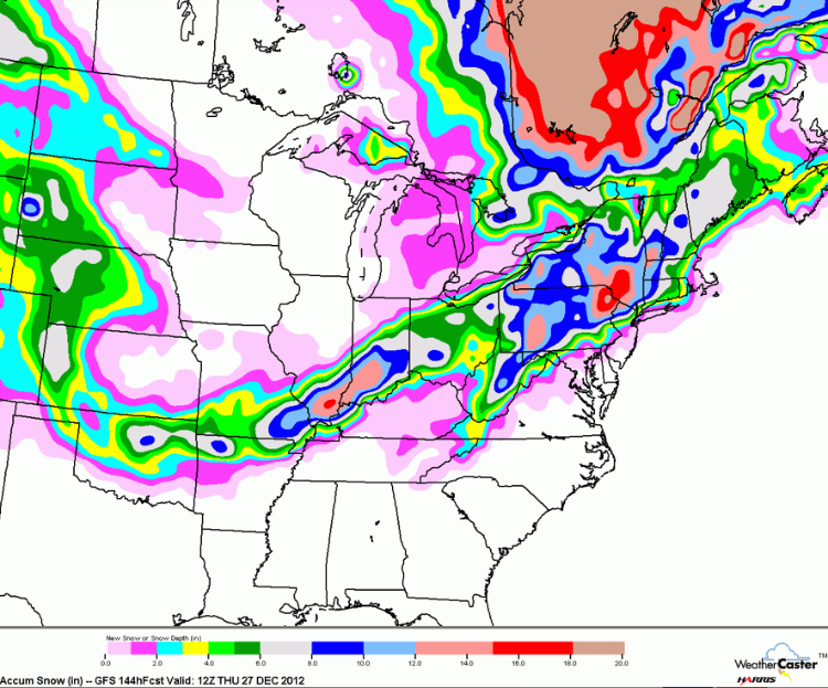
GFS gives Berkshires a foot of snow, and close to nothing at whiteface. Anyone else have access to other models and can give a more promising outlook for the face?
-skisheep
ORDA and New England Passholder. If it's fast, it's probably fun.
2014-2015 season days Whiteface: 2 Sunday River: 4 Loon: 2 Hunter: 1 Belleayre: 1 |
|
Yes, there will be two feet at Whiteface.
|
|
Wouldn't that be nice! what model shows that?
-skisheep
ORDA and New England Passholder. If it's fast, it's probably fun.
2014-2015 season days Whiteface: 2 Sunday River: 4 Loon: 2 Hunter: 1 Belleayre: 1 |
|
This system might be a game changer..Big snows for everyone..
"Peace and Love"
|
|
Hooray for snow! I guess this means that the GFS is not representative of the trend, or at least this particular run.
-skisheep
ORDA and New England Passholder. If it's fast, it's probably fun.
2014-2015 season days Whiteface: 2 Sunday River: 4 Loon: 2 Hunter: 1 Belleayre: 1 |
|
Administrator
|
In reply to this post by JasonWx
Quoted for posterity!! :)
"You just need to go at that shit wide open, hang on, and own it." —Camp
|
|
Left foot and Right foot model :)
|
|
I'll take it, although two feet of the white fluffy stuff would be better :)
-skisheep
ORDA and New England Passholder. If it's fast, it's probably fun.
2014-2015 season days Whiteface: 2 Sunday River: 4 Loon: 2 Hunter: 1 Belleayre: 1 |
|
Administrator
|
 Catskills in the wheelhouse
"You just need to go at that shit wide open, hang on, and own it." —Camp
|
|
Catskills indeed! Still a solid 4-6" for Gore/Whiteface, and if thats the worst case scenario(which according to the EURO it is), then I'm a happy man!
-skisheep
ORDA and New England Passholder. If it's fast, it's probably fun.
2014-2015 season days Whiteface: 2 Sunday River: 4 Loon: 2 Hunter: 1 Belleayre: 1 |
|
Administrator
|
That map is way too far out to be legit, but...
I'm thinking the last two storm tracks were very good. It really take a perfect track for everyone to score. Last night's storm and this one looks to be headed in the right direction. IMO it's a good sign. I think the best track for all cuts across the far end of Long Island. (?)
"You just need to go at that shit wide open, hang on, and own it." —Camp
|
|
best track for the cats is a storm that goes left of the box (40n 70w)..so something around 40n 73w
vt hooks up when a low explodes in the gulf of maine and the dacks when a low goes into Conn..of course there are exceptions to the rules.. it's really nice to finally have a potentially cold and snowy pattern to talk about
"Peace and Love"
|
|
New GFS brings the storm west quite a bit. With that makes it warmer but it looks like the temps should still be OK for Gore/Whiteface? Someone correct me if I'm wrong.
-skisheep
ORDA and New England Passholder. If it's fast, it's probably fun.
2014-2015 season days Whiteface: 2 Sunday River: 4 Loon: 2 Hunter: 1 Belleayre: 1 |
|
Hi I am new here. MountSnow is getting some good snow today so I will be heading their tomorrow with my Pricechopper pass hope people on here are having great powder runs today.

Scotty
|
|
Make sure that Price chopper pass is not blacked out tommorow
Want to spend special time with your children, teach them to ski or snowboard. The reward will be endless!
|
|
This post was updated on .
Looks like this storm is just about done:
THE FORECAST FOR VANDERWHACKER MOUNTAIN, NEW YORK AT 3,389 FT: LAST UPDATED AT 549 PM EST SAT DEC 22 2012 .TONIGHT...MOSTLY CLOUDY. SCATTERED SNOW SHOWERS UNTIL MIDNIGHT. NEAR STEADY TEMPERATURES AROUND 12. WEST WINDS 25 TO 40 MPH. WIND CHILL VALUES AS LOW AS 15 BELOW. .SUNDAY...CLOUDY IN THE MORNING...THEN SUMMITS BECOMING IN AND OUT OF CLOUDS. A CHANCE OF SNOW SHOWERS. HIGH AROUND 21. WEST WINDS 25 TO 40 MPH...DECREASING TO 20 TO 30 MPH IN THE AFTERNOON. WIND CHILL VALUES AS LOW AS 12 BELOW. .SUNDAY NIGHT...CLOUDY UNTIL MIDNIGHT...THEN BECOMING PARTLY CLOUDY. A CHANCE OF SNOW SHOWERS UNTIL MIDNIGHT. LOW AROUND 17. WEST WINDS 15 TO 30 MPH. WIND CHILL VALUES AS LOW AS 7 BELOW. .MONDAY...PARTLY SUNNY. NEAR STEADY TEMPERATURES AROUND 16. WEST WINDS 15 TO 30 MPH...DECREASING TO 5 TO 15 MPH IN THE AFTERNOON. WIND CHILL VALUES AS LOW AS 9 BELOW. However there is a new one on the horizon: WEDNESDAY NIGHT INTO THURSDAY...THE PRIMARY LOW DECAYS WITH THE NEW LOW FORMING NEAR THE NJ COAST. THE H500 CLOSED CIRCULATION IS A LITTLE FURTHER NORTH...FOR A MIX OF PCPN POTENTIALLY BASED ON THE CRITICAL PARTIAL THICKNESSES OFF THE 12Z GFS AND ECMWF. WE ADDED A CHANCE OF SLEET FROM THE CAPITAL REGION SOUTH. WE ARE NOT CONVINCED ENOUGH WARM AIR WILL INTRUDE FOR RAIN OR FREEZING RAIN. A LOT CAN STILL CHANGE OVER THE NEXT FEW DAYS. THE HPC TRACK TAKES THE CYCLONE SOUTH OF LONG ISLAND BY 12Z THU. THIS POTENTIALLY COULD BE A SIGNIFICANT SNOW EVENT FOR THE INTERIOR ZONES FROM THE CAPITAL REGION NORTH AND WEST...AND WE WILL CONTINUE TO MENTION IT IN THE HWO. LIKELY POPS WERE STILL UTILIZED WED NIGHT...AND CHC POPS WERE USED ON THU...THOUGH MOST OF THE GUIDANCE HAS DEFORMATION SNOWFALL AS THE COLD CONVEYOR BELT KICKS IN...AND THE H500 CIRCULATION MOVES OVER ERN NEW ENGLAND. Various forecast models are predicting an event for Wed night and or Thursday. The NOAA Mountain forecast is looking quite favorable. |
|
12-28-2012=Thursday :) Agreed though the monday-tuesday thing is probably not happening
-skisheep
ORDA and New England Passholder. If it's fast, it's probably fun.
2014-2015 season days Whiteface: 2 Sunday River: 4 Loon: 2 Hunter: 1 Belleayre: 1 |
|
This post was updated on .
The strom for mid week still seems in the forecast with another for the weekend shaping up as well. Could be a nice week in the Daks.
.LONG TERM /WEDNESDAY THROUGH SUNDAY/... A STORM SYSTEM WILL BE LIFTING UP OUT OF THE DEEP SOUTH TOWARDS THE CENTRAL APPALACHIAN REGION DURING WEDNESDAY MORNING. ANOTHER AREA OF LOW PRESSURE WILL BE DEVELOPING TO THE LEE OF THE MOUNTAINS ALONG THE MID ATLANTIC COAST...AND THIS LOW PRESSURE AREA TAKE BECOME THE PRIMARY LOW...AS IT RAPIDLY DEEPENS AND LIFTS UP ALONG THE COAST FOR LATE WEDNESDAY INTO WEDNESDAY NIGHT AND THURSDAY MORNING. THE MODELS ARE STILL IN SOME DISAGREEMENT ABOUT THE EXACT TRACK OF THE STORM...WHICH WILL HAVE AN IMPACT ON HOW MUCH WARMING OCCURS BOTH ALOFT AND THE SURFACE ACROSS OUR AREA. THE 12Z ECMWF...WHICH HAS AGREEMENT FROM IT/S ENSEMBLES AS WELL...SHOWS A SLIGHTLY MORE EASTERN AND COLDER TRACK THAN THE 12Z GFS. THE 12Z GEFS SHOWS SOME SPREAD...WITH SOME MEMBERS BEING A LITTLE COLDER THAN THE OPERATIONAL GFS. THE ENSEMBLE MEAN IS VERY SIMILAR TO THE OPERATIONAL /PERHAPS JUST SLIGHTLY FARTHER SOUTH AND EAST THAN THE OPERATIONAL RUN BY THURSDAY/. THE 12Z GGEM AND UKMET ARE SIMILAR TO THE ECMWF AS WELL. FOR NOW...OUR THINKING IS THAT SNOW WILL BE BREAKING OUT ACROSS OUR ENTIRE AREA BY WEDNESDAY AFTERNOON. SOME MIXING WITH SLEET AND PERHAPS EVEN FREEZING RAIN WILL OCCUR BY THE EVENING HOURS ACROSS FAR SOUTHERN AREAS...WITH SLEET REACHING THE CAPITAL REGION BY ABOUT MIDNIGHT OR SO. A CHANGE OVER TO SOME FREEZING RAIN AND SLEET WILL BE POSSIBLE AS WELL TOO FOR AREAS SOUTH AND EAST OF THE CAPITAL REGION FOR THE SECOND HALF OF THE NIGHT. A TRANSITION TO PLAIN RAIN IS POSSIBLE FOR FAR SOUTHERN AREAS TOWARDS DAYBREAK THURSDAY. IT'S STILL TOUGH TO SAY IF A TRANSITION TO PLAIN RAIN WILL OCCUR UP TO THE CAPITAL REGION. FURTHER NORTH...IT LOOKS MAINLY SNOW FOR THE MOHAWK VALLEY...ADIRONDACKS AND LAKE GEORGE AREA...ALTHOUGH SOME MIXING WITH SLEET WOULD BE POSSIBLE FOR A BRIEF PERIOD TOWARDS THE END OF WEDNESDAY NIGHT. THE PRECIP SHOULD START TO TRANSITION BACK TO SNOW FOR THE TAIL END OF THE STORM FOR DURING THE DAY THURSDAY...ALTHOUGH SOME VALLEY AREAS IN SOUTHERN PARTS OF THE AREA COULD END AS JUST A PLAIN RAIN IF THE SFC TEMPS RISE UP ENOUGH. QPF AMOUNTS ARE STILL IN QUESTION AS WELL...BUT ALL MODELS ARE SHOWING AT LEAST A MODERATE AMOUNT OF PRECIP. MODEL QPF VALUES RANGE FROM AROUND 0.70 INCHES TO 1.50 INCHES...DEPENDING OF WHERE YOU ARE AND WHICH MODEL YOU PREFER. SINCE THE DEGREE OF MIXING IS STILL UNKNOWN...IT/S DIFFICULT TO DETERMINE EXACT SNOW/ICE AMOUNTS. HOWEVER...WITH A MODERATE TO HEAVY AMOUNTS OF PRECIP POSSIBLE...A PLOWABLE SNOW IS LIKELY FOR MANY AREAS...AND WE WILL INCLUDE MENTION OF THIS EVENT WITHIN OUR HAZARDOUS WEATHER OUTLOOK STATEMENT. SOME LINGERING CYCLONIC FLOW/UPSLOPE SNOW SHOWERS WILL BE ACROSS THE REGION FOR THURSDAY NIGHT AND FRI...MAINLY ACROSS THE HIGHER TERRAIN. TEMPS WILL BE CLOSE TO SEASONAL VALUES...WITH 20S AND 30S FOR HIGHS...AND TEENS AND 20S FOR LOWS. IT SHOULD CLEAR OUT FOR FRIDAY NIGHT AS A BRIEF AREA OF HIGH PRESSURE BUILDS ACROSS THE REGION. THE MODELS DISAGREE AGAIN FOR THE WEEKEND...WITH THE ECMWF SHOWING A COASTAL STORM...WHICH WOULD BRING MORE SNOW AND/OR MIXED PRECIP TO THE AREA...WHILE THE GFS SHOWS ANY STORM REMAINING OFFSHORE. THERE IS SOME SUPPORT FOR A STORM IMPACTING OUR AREA FROM SOME OF THE MEMBERS OF THE 12Z GEFS. FOR NOW...WILL GO WITH CHC POPS FOR SAT/SUN AND CONTINUE TO MONITOR MODEL TRENDS...WITH TEMPS OVER THE WEEKEND AVERAGING CLOSE TO NORMAL. |
|
Administrator
|
Jason, Noreaster, weather experts... timing of this storm is an issue for our family - ladies don't want to drive on Christmas Day, but I may have to do it, if we can avoid driving in it. Best guesses as to timing and Ptype by region (Flatlands, Hudson Valley, Capital District, North Country) are welcome.
"You just need to go at that shit wide open, hang on, and own it." —Camp
|
«
Return to Weather Archive
|
1 view|%1 views

