From Rebecca’s forecast:
No Really changes or anything really unexpected going on as far as Florence goes. She seems to be reading my ideas, as she has been following what I've been saying quite closely.
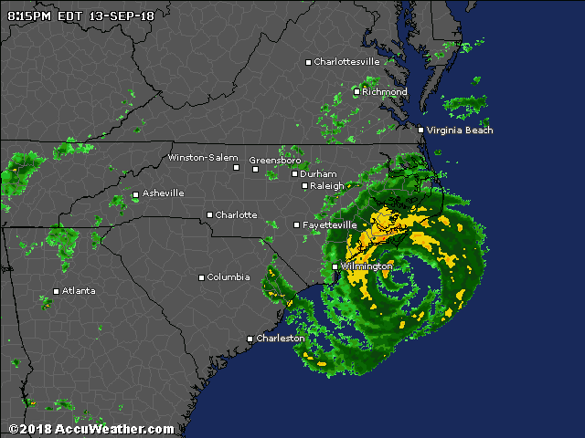
Hurricane Florence is rapidly intensifying on its path toward the East Coast and is now a Category 4 with 140 mph winds. Her Central Pressure is at 939 mb, moving west northwest at 13 mph. On satellite we can see she is a well developed and defined hurricane with strong in and out flow. She is a very large hurricane a little more than 500 miles across. So she will impact a large area.
She is moving though an idea environment as she tracks toward the Carolina's. So she will continue to intensify. I've been saying for quite some time that Florence will be a major hurricane at landfall. If she makes landfall as a strong Category 3 or 4 hurricane, points north of center eye would see a storm surge of 15' to 20', if she comes in as a Category 5 hurricane a storm surge of 20'-28' would be likely. Here are charts showing the estimated storm surge at landfall. Some of this surge might even impact areas as far north as Long Island. On top of the surge we will see huge waves. wave heights of 40-50 feet would be possible approaching the North Carolina Coast. The Carolina's have never seen a hurricane like Florence at landfall. The strongest hurricanes to make landfall in the Carolina's since official records began in 1851 were: Hurricane Hazel (1954), Hurricane Gracie (1959), and Hugo (1989). Florence could be coming in stronger than those three; if that happens it would make Florence the strongest hurricane to make a landfall that far north in recorded history (since 1851). She almost certainly will make a landfall of at least a Category 4. Landfall is looking to be Thursday. A hurricane of 150-165 mph would be a huge disaster for the Carolina's. She will lose her steering influences, and will stall and mill around the southern Appalachians for a few days ; this will lead to 2-4 feet of rain inland into South and North Carolina, Virginia, West Virginia under a stalled Florence would be the worst disaster to ever hit that region. She will lose her steering influences, and will sit around thinking about where she want's to go. After that she could go in one of three tracks. one would be into the Ohio Valley and over the lower Lakes, two, loop to the north and northeast trying to make it back to the Mid Atlantic Coast. 3) she could even loop south and southeast to try and make it back to the Southeast Coast. Of the three 2 and 3 are more likely than 1.
Florence is living up to my worst case scenario Mandatory evacuation orders have been issued on the Southeast Coast. Virginia Gov. Ralph Northam declared a state of emergency Saturday in anticipation of the impact of Hurricane Florence, Governor Roy Copper has declared a State of Emergency for the state of North Carolina. Gov. Henry McMaster in South Carolina has done the same. Maryland Gov. Larry Hogan has also declared a State of Emergency. The Navy is sending their ships out to sea. There are already rip currents along the Southeast Coast. Mandatory evacuation haven't been order yet for Virginia, but officials are saying they could be. Once Florence gets close to the Carolina's conditions will go downhill fast. Take the warnings and evacuation advice from the NHC and your local officials.
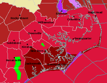
I've included a chart where I take a stab at where I think the heaviest rains will be......but this is subject to change. I think parts of southern Pennsylvania could end up with 4-near 12 to inches of rain.........
Could the northwest Gulf see a tropical storm and of this week? Maybe...that yellow highlighted area in the western Gulf could bring Texas some tropical weather.
Isaac will most likely fall apart in the Caribbean as conditions become unfavorable.
I ride with Crazy Horse!