Speaking of the Polar Vortex, this discussion of Arctic Oscillation is interesting. A negative AO (currently) is something that would push systems (like this weekend's Northeast dud) south. Also interesting that the analysis calls for the AO to turn more neutral, resulting is sudden stratospheric warming, which is consistent with the warm up Jason said is coming in a week or so. Fascinating stuff.
This from Atmospheric and Environmental Research (AER).
January 18, 2016
Summary
• The Arctic Oscillation (AO) is currently strongly negative but is predicted to slowly trend closer to neutral over the next two weeks.
• The negative AO is reflective of positive pressure/geopotential height anomalies over the entire Arctic basin while the mid-latitudes are dominated by negative pressure/geopotential height anomalies, including the Eastern United States, Europe and East Asia. This is a significant weakening of the strength of the polar vortex in the troposphere and a southward displacement of the Jet Stream.
• The negative AO atmospheric state has resulted in Arctic air widespread across Central Canada, the United States, parts of Europe, Siberia and East Asia and has contributed to the advance of snow cover both in Europe and the United States.
• With the AO predicted to now trend closer to neutral there could be some relaxation of the cold pattern across the Northern Hemisphere (NH) in the short term.
• Our confidence continues to grow that a significant disturbance or perturbation of the polar vortex (PV) is about to commence that could potentially culminate in a major sudden stratospheric warming (SSW).
• The perturbation of the polar vortex is likely to dominate the evolution of the temperature variability across the NH for the duration of winter. The expected SSW should favor for much of February and even into March a negative AO, and relatively cold temperatures for the NH mid-latitude continents. With the models predicting the PV to move into northern Eurasia we are most confident of the cold close in proximity with the position of the PV. More uncertainty exists across North America as the flow around the PV continues to shift from westerly (warm) to northerly (cold) and now easterly.
Impacts
Dramatic changes in the polar vortex (PV still seem likely with important implications for hemispheric weather that continue to favor the continuation of wintry weather.
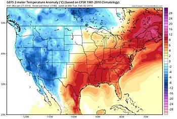
The AO remains strongly in negative territory (probably the most negative January since at least 2010) as positive geopotential height anomalies dominate the Arctic while geopotential heights have lowered across the mid-latitudes. With the AO bottoming out, cold air has become more expansive both across Eurasia and North America. Currently the polar vortex is elongated, establishing cross-polar flow from Siberia into North America. Across northern Eurasia, a strong and expansive Siberian High has resulted in very cold temperatures in much of Siberia that has spread both west into Europe and east into East Asia. The current weather pattern is a good example of why I like to say Siberia is the refrigerator of the NH.
Initially there are two dominant areas of positive geopotential height anomalies in the mid-to high-latitudes with one region of positive geopotential height anomalies centered over Greenland with ridging/positive geopotential height anomalies spread across the North American Arctic. This in turn is displacing a piece of the tropopospheric PV southward across the Great Lakes. Negative geopotential height anomalies stretch from southern Hudson Bay southward to the Gulf Coast. This pattern has yielded relatively mild temperatures for Alaska, northeastern Canada and Greenland but well below normal temperatures for the Canadian and United States Plains and much of the Eastern United States. This pattern will be in place through the week but as the AO trends positive, temperatures are predicted to become more seasonable across the Central and Eastern United States.
The other region of positive geopotential height anomalies is centered over Western Siberia with a strong surface reflection in the mean sea level pressure field and an impressive Siberian High. The strong ridging/building of geopotential heights both across Siberia and Greenland are forcing negative geopotential height anomalies across much of Europe. Similarly the strong ridging/building of geopotential heights both across Siberia is forcing negative geopotential height anomalies across China. This strongly blocked atmospheric circulation, in the shape of the Greek letter omega, has resulted in a generally cold pattern across Eurasia. Some notable exceptions to the cold pattern are across northcentral Siberia close to the region of Arctic warming and southwestern Asia, which is under the influence of a mild southwesterly flow of air downstream of the trough of low pressure dominating Europe.
Longer term we continue to expect that variability in the polar vortex to strongly influence Northern Hemisphere (NH) weather patterns. Our confidence continues to grow that a troposphere-stratosphere-troposphere coupling event (T-S-T) is underway Cohen etal (2007) that will result in a sudden stratospheric warming (SSW). Details of which are given below but based on a correct anticipation of a T-S-T we expect the following AO trends long-term. The initial tropospheric precursor is predicted to initiate a strong transfer of energy from the troposphere to the stratosphere that will also force a positive in the AO this week. In contrast, the predicted strong pulse of vertical energy will force a negative trend in the stratospheric AO as the polar vortex becomes more and more perturbed. Once the SSW peaks, the tropospheric AO will once again trend negative and the overall negative AO should persist for much of the remaining winter.
General temperature trends across the Northern Hemisphere (NH) should mirror trends in the AO. With the AO well into negative territory, cold temperatures may peak this week, at least temporarily especially across North America. However following the SSW, the AO will once again trend negative and similarly NH temperatures should also turn relatively colder. The models are predicting for the PV to pinwheel off the Pole towards northern Eurasia. This position of the PV favors the coldest temperatures to follow. Therefore we are most confident in an overall cold pattern for the latter half of winter across Northern Eurasia including Europe. With the cross-polar flow of air from Siberia to North America shut down (for the first time in three winters), temperature anomalies for the Eastern United States are more uncertain. However potentially expansive snow cover and weak flow associated with the PV may favor colder temperatures than otherwise expected.
We REALLY need a proper roll eyes emoji!!