Winter Weather 2019-2020

classic Classic list List threaded Threaded
302 messages Options
1 ... 3456789 ... 16
Reply | Threaded
Open this post in threaded view
|

Re: Winter Weather 2019-2020

campgottagopee
Doesn't look too bad once we get to Sunday. Snow will be making it's return
Reply | Threaded
Open this post in threaded view
|

Re: Winter Weather 2019-2020

PeeTex
Wed next week is looking like the day to go.
Don't ski the trees, ski the spaces between the trees.
Reply | Threaded
Open this post in threaded view
|

Re: Winter Weather 2019-2020

Harvey
Administrator
PeeTex wrote
Wed next week is looking like the day to go.

Destination suggestions welcome.
"You just need to go at that shit wide open, hang on, and own it." —Camp
Reply | Threaded
Open this post in threaded view
|

Re: Winter Weather 2019-2020

PeeTex

WF,  Gore, Platty or GP should get some love. Nothing big but at this point...
Harvey wrote
PeeTex wrote
Wed next week is looking like the day to go.

Destination suggestions welcome.
Don't ski the trees, ski the spaces between the trees.
Reply | Threaded
Open this post in threaded view
|

Re: Winter Weather 2019-2020

Harvey
Administrator
AREA FORECAST DISCUSSION
National Weather Service Albany NY
346 PM EST Fri Jan 3 2020
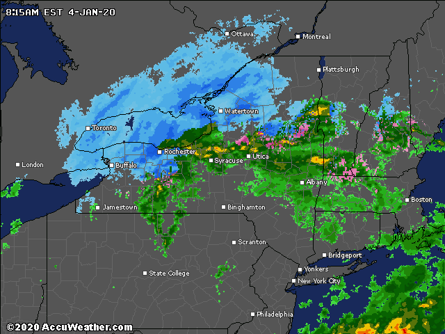
.SYNOPSIS...
A cold front will remain west of the region overnight, as a low
pressure system moves northeast from the Ohio Valley with rain
mainly moving into the region Saturday morning. Colder air will
move back into the area Saturday afternoon into early Sunday
morning transitioning rain to some accumulating snow for most of
the region. Seasonably cold and brisk conditions will close the
weekend with near normal temperatures.

&&

.NEAR TERM /UNTIL 6 AM SATURDAY MORNING/...

Cloudy sky with light winds will prevail through the night. Weak
upper energy will support patchy light rain with the best
coverage in southern areas. By daybreak, stronger upper energy
and better low level forcing approaches and better coverage of
light rain builds into southern areas. Lows tonight in the mid
30s to near 40 with lower 30s well north.

&&

.SHORT TERM /6 AM SATURDAY MORNING THROUGH MONDAY/...

Upper energy tracking around the periphery of east coast flat
upper ridging will increase the low level flow, warm advection
and isentropic lift Saturday morning and afternoon. The best
coverage of precipitation is expected to be along and north of
the Mohawk Valley to northern Berkshires and southern Vermont.
There is a good consensus from guidance/ensembles for the system
to exit through the afternoon and evening and deep cooling will
build east and south through the day.

Based on forecasted thermal and moisture profiles as well as
vertical motion, parts of the southern Adirondacks and Lake
George area may have mostly a mix of snow and rain Saturday
changing to all snow Saturday afternoon and ending early
Saturday evening. Areas from the southern Adirondacks through
Lake George and northern Saratoga Region to the higher peaks of
the southern Green Mountains could see 3-5" before ending but
again, mainly confined to higher peaks.
 So, no headlines due to
limited areal coverage.

All other areas should see mainly rain at the start with
possible intervals of sleet, transitioning through a period of
rain and snow, then ending as a period of snow with light
accumulations of dustings in valleys to an inch or two in the
eastern Catskills, Taconics and Berkshires. The core of vertical
motion across the entire region looks to be centered well below
the dendritic growth zone, which should limit the snow to
liquid ratios to near or below climatological 12 to 1. Highs
Saturday in the lower to mid 40s but 30s in higher terrain.

All steady precipitation is expected to end Saturday evening
and as the system exits, deep cold advection begins and gusty
northwest winds spread across the region. Lake effect snow
shower activity should set up mainly west of our region due to
the north to northwest low level flow. Still, including some
chances for snow showers in western areas.

Gusty northwest winds and intervals of clouds and sun are
expected Sunday as cold advection continues. Winds diminish
during the afternoon and trends to west and southwest toward
Sunday evening. Highs in the 30s but around 40 southern areas
and mid 20s to around 30 northern areas.

Northern stream upper energy approaches from southern Canada and
the Great Lakes Sunday night, tracking through our region
Monday. Increasing warm advection and isentropic lift along with
some moisture off the Great Lakes should support lake enhanced
snow into parts of the western Mohawk Valley, Schoharie Valley
and southern Adirondacks. Scattered snow shower activity is
likely over the rest of the region as well. There could be a few
inches of snow in western areas into the southern Adirondacks
with some dustings to maybe an inch from the Capital region and
points east and south. Highs Monday in the 30s but around 40
southern areas and around 30 to lower 30s higher terrain.

&&

.LONG TERM /MONDAY NIGHT THROUGH FRIDAY/...
Active weather will continue through much of the long term period.

Most of the area should start off fairly dry to start the extended
period for Monday night into Tuesday as a shortwave departs across
Quebec. Temps will remain seasonable across the region with lows in
the 20s and highs in the 30s.

However, the next system will quickly be approaching within the
southwest flow aloft from the Ohio Valley and Midwest.   An open and
progressive shortwave will be accompanied by a fast moving surface
low that will be tracking across the mid Atlantic and southern New
England states.  With a storm taking this track and just enough cold
air in place, a period of steady precip should mainly be in the form
of snow for Tuesday night into Wednesday.
  As of right now, can`t
rule out some rain mixing in for southern areas, and this will be
subject to change based on the exact track which is still uncertain.
Otherwise, models seem to agree that a light to moderate snowfall
will occur for most of the area (mainly for late Tuesday night into
Wednesday morning).  Temps will continue to be close to normals.

Behind this system, dry weather should return, as high pressure and
upper level ridging move in for Thursday.  Any break in the weather
looks brief, though, as another storm should be moving in for Friday
into the weekend.  This next one looks a little warmer, with a mix
or some rain, but will ultimately depend on its exact track and
timing, which is still far from certain at this time.
"You just need to go at that shit wide open, hang on, and own it." —Camp
Reply | Threaded
Open this post in threaded view
|

Re: Winter Weather 2019-2020

JTG4eva!
Damn, gotta go back and read Harvey’s loooong post.

Now, maybe this would fit better in A Fine Whine.....but did anyone see Rebecca’s post in her FB group?  She’s packing up all her marbles and going home, on account of all the FB haters hating on her.  
We REALLY need a proper roll eyes emoji!!
Reply | Threaded
Open this post in threaded view
|

Re: Winter Weather 2019-2020

MC2 5678F589
JTG4eva! wrote
Damn, gotta go back and read Harvey’s loooong post.

Now, maybe this would fit better in A Fine Whine.....but did anyone see Rebecca’s post in her FB group?  She’s packing up all her marbles and going home, on account of all the FB haters hating on her.  
I did see that! Wild!
Reply | Threaded
Open this post in threaded view
|

Re: Winter Weather 2019-2020

PeeTex
In reply to this post by JTG4eva!
I think Harv posted a long thome that basically says areas in the Adirondacks and western Cats will get some love.
Don't ski the trees, ski the spaces between the trees.
Reply | Threaded
Open this post in threaded view
|

Re: Winter Weather 2019-2020

Johnnyonthespot
In reply to this post by MC2 5678F589
MC2 5678F589 wrote
JTG4eva! wrote
Damn, gotta go back and read Harvey’s loooong post.

Now, maybe this would fit better in A Fine Whine.....but did anyone see Rebecca’s post in her FB group?  She’s packing up all her marbles and going home, on account of all the FB haters hating on her.  
I did see that! Wild!
That shit is funny! Meltdown of epic proportions.
I don't rip, I bomb.
Reply | Threaded
Open this post in threaded view
|

Re: Winter Weather 2019-2020

Harvey
Administrator
In reply to this post by JTG4eva!
Yea just check the bold part.  :)
"You just need to go at that shit wide open, hang on, and own it." —Camp
Reply | Threaded
Open this post in threaded view
|

Re: Winter Weather 2019-2020

Harvey
Administrator
In reply to this post by JTG4eva!
I am crushed.
"You just need to go at that shit wide open, hang on, and own it." —Camp
Reply | Threaded
Open this post in threaded view
|

Re: Winter Weather 2019-2020

JasonWx
In reply to this post by Harvey
500 words to say BLAH....
"Peace and Love"
Reply | Threaded
Open this post in threaded view
|

Re: Winter Weather 2019-2020

Saratogahalfday
So if I hit Magic early tomorrow, it's going to be raining?
Reply | Threaded
Open this post in threaded view
|

Re: Winter Weather 2019-2020

JasonWx
It's raining there now..maybe a little mixed
"Peace and Love"
Reply | Threaded
Open this post in threaded view
|

Re: Winter Weather 2019-2020

Harvey
Administrator


On the cams right now it looks like Gore is clinging to frozen precip.  Don't see frozen on Magics cam.
"You just need to go at that shit wide open, hang on, and own it." —Camp
Reply | Threaded
Open this post in threaded view
|

Re: Winter Weather 2019-2020

PeeTex
I saw this set of statistics for average decadal snowfall for cities around the US. Seems like no statistical change in the last 120 years except for maybe Sault St. Marie which is showing a significant increase. The article states there could be an upward bias in the data as estimates in early years were taken from water content and in more recent years using snow boards.


https://www.wunderground.com/cat6/US-Snowfall-1900-2019-Decade-Decade-Look?cm_ven=cat6-widget 
Don't ski the trees, ski the spaces between the trees.
Reply | Threaded
Open this post in threaded view
|

Re: Winter Weather 2019-2020

Saratogahalfday
In reply to this post by Harvey
Ya, it was raining at 7 this morning so I bagged it.  I'll ski in anything...except rain.

Awful day in Southern VT.
Reply | Threaded
Open this post in threaded view
|

Re: Winter Weather 2019-2020

NorEaster27
Nice snow today in the mountains gore to face to NNE
Reply | Threaded
Open this post in threaded view
|

Re: Winter Weather 2019-2020

PeeTex
NorEaster27 wrote
Nice snow today in the mountains gore to face to NNE
Yes - we had some snow up on the Northern Hudson. The flood sensor for my dishwasher came in the mail today so I put that in rather than go out. That way I can ski later in the week and the misses will stop bugging me to buy a new dishwasher.
Don't ski the trees, ski the spaces between the trees.
Reply | Threaded
Open this post in threaded view
|

Re: Winter Weather 2019-2020

Saratogahalfday
It looks like another washout this week, Friday - Saturday.

This could be the winter that never was.  
1 ... 3456789 ... 16