Gore Conditions (2017 - 2018)
1 ...
11121314151617
... 31
1 ...
11121314151617
... 31
|
Conditions generally good all around.
Upper mountain was generally firm and fast but edgeable. Chatiemac fairly scraped down. Hawkeye under the guns was fun. Lies was firm -- a combination of what seemed like relatively new blow and scraped down sections. Open Pit was great. Guns blasting away on Rumor (not open yet). Headwaters fine. Tannery was hardpack. Did not get over to Topridge -- it looked good from the chair, but I saw them putting a rope up at around 2, which I thought weird. Dark Side has benefitted from snowmaking. Lower Darby was fun, Wood Lots have much better cover than 2 weeks ago. North Side -- Sleeping Bear has good cover, seemed to ski fast. Did not ski Pete Gay but overheard someone speaking positively. Tahawus closed. Foxlair has good cover. Ruby Run was fine. Saddle had some ice showing by midday. Twister has great cover. Showcase was great in the early morning, scraped down in a number of places by lunchtime. Wild Air had the best snow of the day. Arena has good cover. Did not ski Sunway, Quicksilver or Burnt Ridge. Mountain is set up well for some snowfall. The Darkside glades and Double Barrel look pretty much skiable now. If we could get 10 inches of new snow it will open the whole mountain and provide great conditions going into mid-Feb. Good job by Gore staff for flagging big ice patches and other lingering hazards. Petronio |
|
Administrator
|
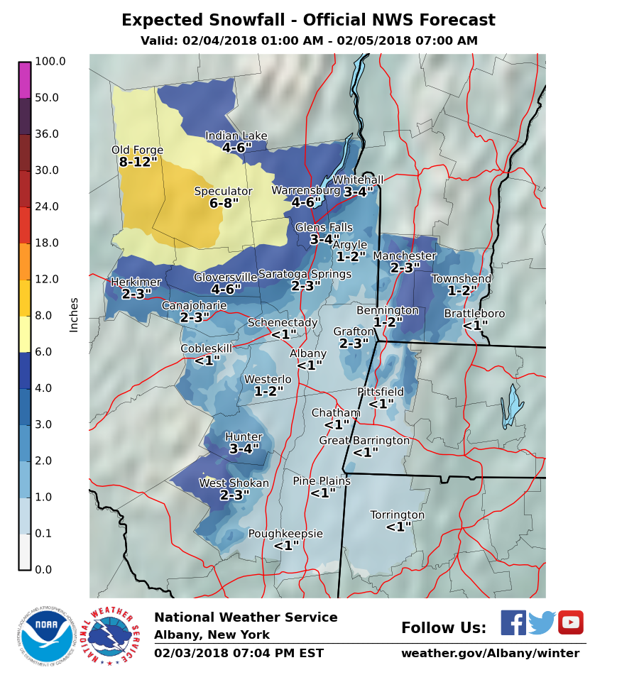
As this map has been updated today, it is looking better and better for Gore, getting close to warning criteria:
"You just need to go at that shit wide open, hang on, and own it." —Camp
|
|
Administrator
|
As surmised, WSW for South Central Adk:
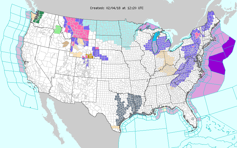 That is looking very likely. First of two events could provide most of the 10 you are looking for... 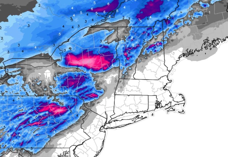
"You just need to go at that shit wide open, hang on, and own it." —Camp
|
|
Administrator
|
I heard the womenfolk we're poaching Tahawas Trees today. Should be game on by middle of the week.
Hey sno... What is the uphill capacity at the ski bowl?
"You just need to go at that shit wide open, hang on, and own it." —Camp
|
|
So how was Gore? Headed there but just missed two sets of deer on snowy roads at 7am in Hamilton county and said no way doing 150 miles today in these conditions. Looks like after wed storm we are in a really good place. At last
|
|
In reply to this post by Harvey
The mountain was skiing good today, we've picked up a solid 12"+ at our camp in Johnsburg which appeares to be a bit more than on the mountain, hard to tell as the wind was blowing at the higher elevations.
A lot of gun pow on Hawkeye, without the tower guns running it was loud but very skiable. Even though it was snowing hard all day, that hard pack kept poking its ugly head out. Sagamore skied great on trails edge. My personal fav, though a bit mellow, was Pete Gay which was holding nice fresh snow with unbroken pow on the edge. If the next storm pans out like they are forecasting, Thursday might be one of the best ski days in a long time. I'm already planning to take the day off, drive up Wednesday night and try to score fresh tracks. Rumor guns going hard. I suspect they will open it up any day now. If we get a big dump Wednesday, Rumor might be the place to be early Thursday morning. If anyone can play hooky tomorrow, I would say you're going to be treated to some really good skiing. Some short clips from the day today. |
|
I was there today until the end and tried to play the best at the very end before the ropes went up. I think I am playing hooky tomorrow. The trees will be great...some were today. It was pounding down when I left. It is hard to judge how much fell because the wind was so strong...but it lands in the usual spots after a big storm with wind.
 skiing got very quiet by the time they kicked us out. skiing got very quiet by the time they kicked us out.
ski you tomorrow 
Proud to call Gore My Home Mountain
Covid stole what would have been my longest season ever! I'll be back |
|
Only 7 inches at Gore yesterday? Odd considering reports of 20 inches about 20 miles away
|
|
I can see that. We were on the mountain all day and it just wasn't accumulating as much as I anticipated (perhaps because of the wind?). When we returned to our camp in Johnsburg, it was dumping, total snow bomb and it didn't stop until late. Looking at it this morning, I would say 14"+
|
|
Administrator
|
I also think the 7 inches is pretty close. I'll call it Emily conservative - I think she is pretty darn accurate, maybe slightly on the conservative side. I wasn't skiing this weekend, but I had my nose pressed up against the glass (radar) most of the day. The snow was much more intense just to the south, and I was glad we weren't getting skunked. It looked to be a lot less just to the north in Essex County.
Mike is that Johnsburg the village? If you had 14" and Snowhunter had 20 in Stony Creek, that makes the point. Be very interested to see the NWS final numbers.
"You just need to go at that shit wide open, hang on, and own it." —Camp
|
|
https://forecast.weather.gov/product.php?site=NWS&issuedby=ALY&product=PNS&format=CI&version=1&glossary=1&highlight=off
Public Information Statement Spotter Reports National Weather Service Albany NY 422 AM EST Mon Feb 05 2018 The following are unofficial observations taken during the past 13 hours for the storm that has been affecting our region. Appreciation is extended to highway departments, cooperative observers, Skywarn spotters and media for these reports. This summary also is available on our home page at weather.gov/albany ********************STORM TOTAL SNOWFALL******************** LOCATION STORM TOTAL TIME/DATE COMMENTS SNOWFALL OF /INCHES/ MEASUREMENT MASSACHUSETTS ...Berkshire County... Savoy 2.2 459 PM 2/04 WeatherNet6 NEW YORK ...Albany County... Knox 3.9 1025 PM 2/04 WeatherNet6 1 NE Shakers 1.9 700 PM 2/04 Albany Int`l Airport Albany 1.8 700 PM 2/04 WFO Albany 2 W Albany 1.8 1115 PM 2/04 0.24 inch liquid 1 W Albany 1.6 721 PM 2/04 NWS Employee Boght Corners 1.6 838 PM 2/04 NWS Employee Colonie 1.5 943 PM 2/04 WeatherNet6 ...Columbia County... Livingston 0.5 535 PM 2/04 WeatherNet6 ...Dutchess County... Red Hook 1.0 413 PM 2/04 WeatherNet6 ...Fulton County... Northville 13.0 928 PM 2/04 WeatherNet6 Fishhouse 8.0 749 PM 2/04 WeatherNet6 Gloversville 7.0 930 PM 2/04 Facebook Mayfield 5.5 410 PM 2/04 Facebook Perth 5.5 956 PM 2/04 WeatherNet6 ...Greene County... Halcott Center 5.0 220 AM 2/05 WeatherNet6 West Kill 3.0 450 PM 2/04 WeatherNet6 Catskill 1.3 637 PM 2/04 WeatherNet6 Cairo 1.0 421 PM 2/04 WeatherNet6 ...Hamilton County... Piseco 15.0 600 PM 2/04 Broadcast Media Wells 12.8 707 PM 2/04 WeatherNet6 1 ENE Eagle Bay 4.3 550 PM 2/04 Trained Spotter ...Herkimer County... 3 NNE Ohio 12.5 615 PM 2/04 Trained Spotter ...Montgomery County... Hessville 5.5 959 PM 2/04 WeatherNet6 Amsterdam 5.2 1004 PM 2/04 WeatherNet6 Glen 4.6 919 PM 2/04 WeatherNet6 Fonda 4.5 958 PM 2/04 WeatherNet6 ...Rensselaer County... Center Brunswick 2.2 954 PM 2/04 WeatherNet6 ...Saratoga County... Lake Desolation 15.3 1032 PM 2/04 WeatherNet6 4 WSW Porter Corners 14.0 600 PM 2/04 Broadcast Media Edinburg 12.8 936 PM 2/04 WeatherNet6 Corinth 12.0 923 PM 2/04 WeatherNet6 Gansevoort 6.0 830 PM 2/04 NWS Employee Clifton Park 2.0 1140 PM 2/04 Facebook ...Schenectady County... Duanesburg 4.5 934 PM 2/04 WeatherNet6 Niskayuna 3.2 638 PM 2/04 Public Schenectady 2.5 1030 PM 2/04 WeatherNet6 1 SSW Aqueduct 1.7 830 PM 2/04 NWS Employee Schenectady-GE Plot 1.5 644 PM 2/04 NWS Employee 1 NNW Niskayuna 1.0 557 PM 2/04 NWS Employee ...Schoharie County... Jefferson 5.5 932 PM 2/04 WeatherNet6 3 N Central Bridge 5.0 925 PM 2/04 Facebook Richmondville 5.0 236 AM 2/05 WeatherNet6 Charlotteville 4.8 850 PM 2/04 WeatherNet6 Schoharie 3.0 941 PM 2/04 WeatherNet6 ...Ulster County... Phoenicia 3.5 429 PM 2/04 WeatherNet6 Woodstock 3.0 530 PM 2/04 Trained Spotter Kingston 1.0 520 PM 2/04 Public ...Warren County... Warrensburg 15.6 1050 PM 2/04 Trained Spotter Johnsburg 13.0 605 PM 2/04 ELEVATION 1450 FT Queensbury 10.0 1130 PM 2/04 Facebook 2 ENE Queensbury 9.1 1032 PM 2/04 CoCoRaHS Glens Falls 8.5 1100 PM 2/04 Broadcast Media ...Washington County... 4 N Hudson Falls 9.5 1040 PM 2/04 Trained Spotter Granville 8.5 1030 PM 2/04 Facebook 4 NE Hartford 5.5 430 PM 2/04 Meteorologist VERMONT ...Bennington County... Landgrove 13.7 945 PM 2/04 WeatherNet6 Woodford 9.5 1009 PM 2/04 WeatherNet6 Manchester 5.0 434 PM 2/04 Facebook ...Windham County... 4 SE Londonderry 6.0 628 PM 2/04 Facebook 4 ESE Jacksonville 2.0 715 PM 2/04 Facebook Wilmington 2.0 500 PM 2/04 Utility Company |
|
Administrator
|
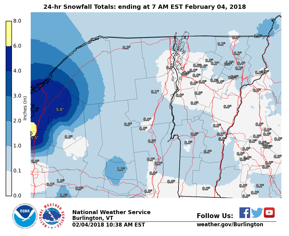
Funny they don't have info for Indian Lake or North Creek. I want to see the update on this:
"You just need to go at that shit wide open, hang on, and own it." —Camp
|
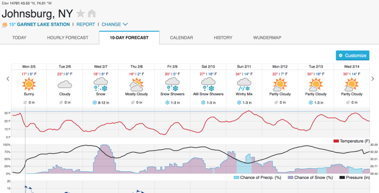 10 Day Forecast Courtesy of Weather Underground Looking upstream from this weekend, if the forecaster really pans out we could be looking at some major accumulation. Add it up, we could see 15" - 20" which would be amazing on top of what we just picked up! |
|
In reply to this post by Harvey
Looks like no trained spotter or official reporters located in Indian Lake or North Creek. There's an opportunity for ya when a class comes to town, which is once a year, one spring, one fall.
|
|
Think Indian Lake was around 6 inches, Speculator to Wells had 18-20 inches.
|
|
looks like some good snow coming Wednesday. I'm off Thursday, I may have to head up to Gore Thursday.
I'll take boilerplate ice over wet snow any day
|
|
So I had so much fun yesterday that I went back first thing this morning. Gore is reporting 7 inches from the storm but I think there was more. KHS(not sure I like the widening in here) yesterday at 2;30 probably had 15-18 inches but they get a lot of blow in. Winds were crazy today and from the wrong direction (as opposed to yesterdays crazy winds from the correct direction). I left at 11am and only the Arctic Express and Burnt Ridge were open. Lower Mt was deer valley cord, Showcase had constant blow in powder, to me the best of those..liftee told me they just opened Burnt Ridge and down twister I went. The rope was down on twister glade (wink wink) and in I went. They had double B netting on Echo so had to exit back onto Twister. From Twisters sister down was deep windblown pow. I am heavy and love junk snow...But then Sagamore! I lapped it until they opened the trees. The woods base is rough...My Mantra was if you are the first in, it was great...try to avoid other peoples tracks. I had a friend up there that just told me the top did open today so I am bummed I left when I did...If we get what it looks like we will get Wednesday, the mountain will be back to where it was prior to the two wet events

Proud to call Gore My Home Mountain
Covid stole what would have been my longest season ever! I'll be back |
|
Snowmaking is moving over to the bowl. They had a fan gun on Eagle's Nest for a while and according to the report are making the move to Oak Ridge and 46er.
I've lived in New York my entire life.
|
|
They did open the top yesterday but Uncas was really windblown - not fun. Straightbrook trails were protected from the wind and were fine. I'm sure most would have loved it but I struggle in these conditions. Lower mountain and Echo skied really well.
Today was even better. They left Hawkeye bumped and groomed Chatimac. Uncas was nice. Darkside was scratchy in between piles of soft snow. Echo was my pick for the day. Guns going on Rumor and there is lots of snow on it. I think it will open soon. Heading to the ski bowl for the snowshoe race. tom |
|
Really looking forward to Saturday, anyone want to ski with?
|
«
Return to Conditions Archive
|
1 view|%1 views

