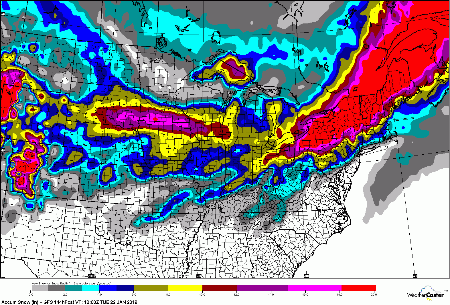
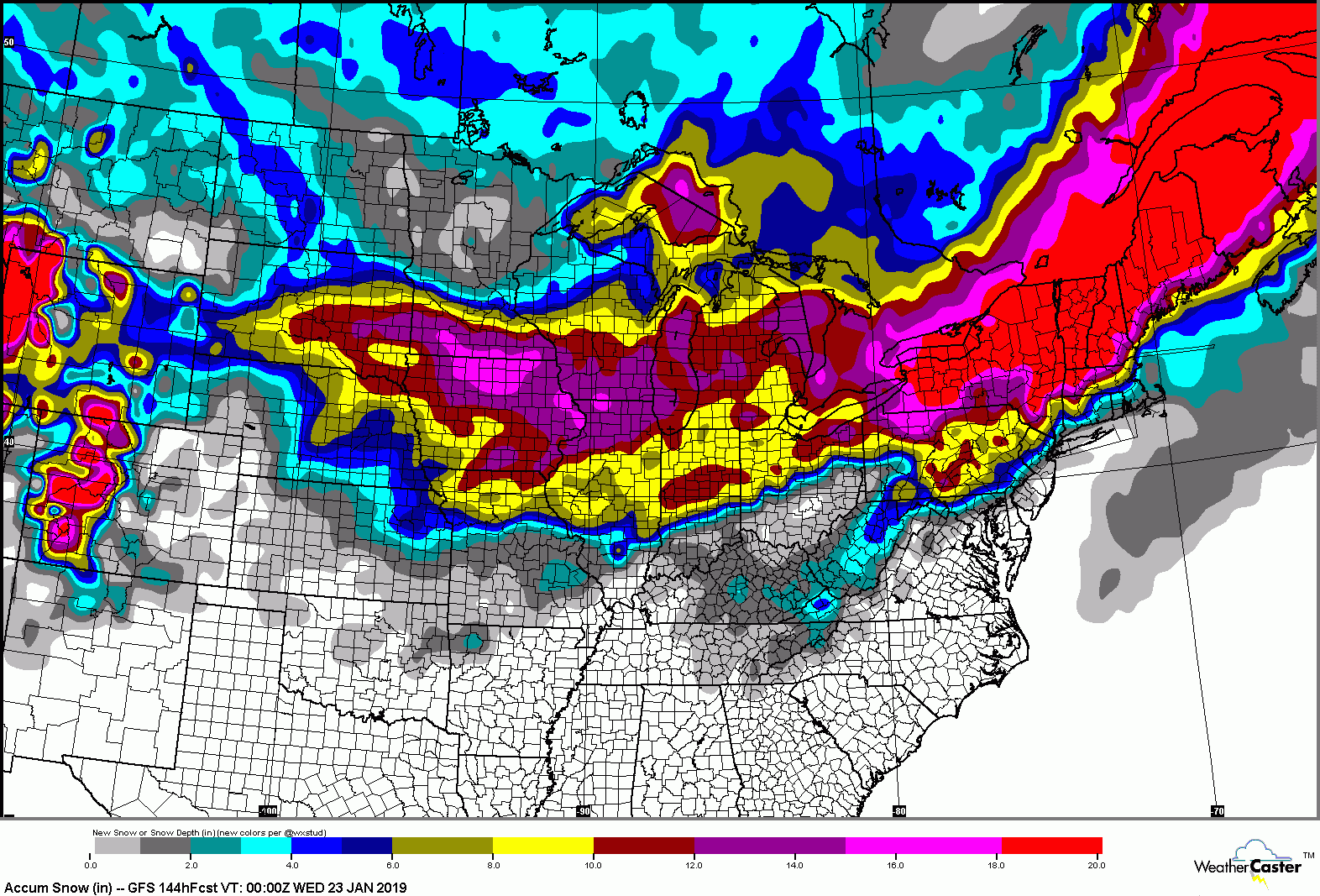
Jan 19 2019 Possibilities
12345678
12345678
|
I'm ready bro!
|
|
Fuck snow tires. I have Dueller H/T's. Just gonna send it!
I don't rip, I bomb.
|
|
FKNA!

|
|
Administrator
|
In reply to this post by Johnnyonthespot
Hahahaha nice Johnny!
I've been sending it all season. Time to pony up.
"You just need to go at that shit wide open, hang on, and own it." —Camp
|
|
Administrator
|
NWS ALY LONG TERM /SATURDAY THROUGH WEDNESDAY/...
Coming soon. Haha. I guess it's complicated. Looking like my only chance is a run for the border. Any met guys want to talk about precip type(s) for the cats?
"You just need to go at that shit wide open, hang on, and own it." —Camp
|
|
Keeping my fingers crossed for all snow in the Cats. Waiting till the last minute to pull the trigger on a room in Vermont on Saturday night is going to be risky on a holiday weekend.
|
|
Administrator
|
Me too. The GFS map is back to a full blowout: 
"You just need to go at that shit wide open, hang on, and own it." —Camp
|
|
My son is supposed to go to Cannon for Saturday SL training day and Sunday race. It’s a us team sponsored event you have to qualify to get in but I’m not seeing any chance they could race on Sunday in this storm. Thoughts?
if You French Fry when you should Pizza you are going to have a bad time
|
nor do I..Sunday it will be full tilt boogie up at Cannon
"Peace and Love"
|
|
Administrator
|
This post was updated on .
Looks to me like forecast got a little bit colder, or extent of mix pushed slightly south. A few details...
NWS ALY LONG TERM /SATURDAY NIGHT THROUGH WEDNESDAY/... Winter Storm Watch in effect from 4 pm Saturday to 7 pm Sunday for all of eastern NY and adjacent Western New England... A major winter storm will impact the forecast area Saturday Night into the Martin Luther King Holiday. Extensive collaboration with WPC and the neighboring WFO`s BGM...BUF...BTV...GYX..BOX...and OKX has warranted a Day 3 to Day 4 Winter Storm Watch, where the potential exists for 9 or more inches of snow in a 24-hr period in most of the area and 7 or more inches of snow possible with a mixture of sleet and freezing rain /ice amounts one tenth to one quarter of an inch/ for the mid Hudson Valley, southern Taconics, and Litchfield County CT. .... Another issue that will play a role with storm is the location of the mixed pcpn or icing zone. We leaned fairly close with the GEFS ensemble mean and the latest 00Z ECMWF where the 0C line at H850 barely gets north of Dutchess and Litchfield Counties. We placed some freezing rain and sleet in the forecast after 06Z/SUN...and continued it into the late morning south and east of the Capital Region. The moisture with this system looks so impressive with total QPF likely in the 1-2" range. The latest 00Z EC gives Albany close to 1.75" for the entire event. The latest mean 00Z GEFS plume gives Albany about 1.60", and KPOU a little over 2.0".
"You just need to go at that shit wide open, hang on, and own it." —Camp
|
|
Administrator
|
This post was updated on .
In reply to this post by Johnnyonthespot
This is sig worthy. It looks like I am buying some other brand. They were $200 cheaper for 4 than the Duellers. Bring your chain Johnny, if you see me in the ditch can you pull me out?  
"You just need to go at that shit wide open, hang on, and own it." —Camp
|
|
I’ve done Mavis off brand stuff a couple of times, but I just couldn’t do the Pro Series for the Jeep. I wanted a real A/T tire. Went with the Yokohama Geolander A/T and saved $40 a tire over the Duelers.
We REALLY need a proper roll eyes emoji!!
|
|
In reply to this post by Harvey
Hopefully the mix line doesn’t get north of Dutchess and the Cats take full advantage of upwards of 2 inches of QPF! The potential issue for the Dacks could be the tight QPF gradient. Last I read yesterday, it might not take that much distance to make a significant difference in QPF. For the Dacks the ratio will probably be 20/1 or more, so even .75 of QPF will return 18 inches. So a great day is likely in store, and if we get more all the better!
We REALLY need a proper roll eyes emoji!!
|
|
Say hypothetically that the Cats get an inch or two of ice mixed into this. If it is at the end of the event, then it is not good then, but presumably it will get groomed out and the earlier stuff is great for the base. Right or wrong?
|
|
In reply to this post by Harvey
I'm supposed to have a tow rope somewhere. Might have been borrowed by a neighbor. I'll bring some gear just in case. I may drive up Sunday am.
I don't rip, I bomb.
|
|
It's looking like CNY is in the bullseye for this one, plus wrap around LE on Monday --- braaaaap!
|
|
Banned User
|

|
|
In reply to this post by DomB
I think the Cats are going to be alright. The GFS is the outlier in terms warm air aloft, but even that only has a wedge getting as far north as the Twin Tiers. Even if things shift a little I don’t think the Cats would be looking at significant icing. A bulk of the precip would come after things change back to snow anyway.
Opensnow for Platty 18-30”. Magic 22-33”. The Cats and Southern Vermont in the current bullseye zone (well, the bullseye zone that matters, Camp!  Opensnow Greek forecast is 13-24”) Opensnow Greek forecast is 13-24”)
The QPF gradient still seems to be the biggest “risk” as you move into the Dacks and North in VT. Opensnow forecast for Gore-Sugarbush 16-24”. Forecast for WF-Stowe 12-22”. You can see the snowfall amounts decrease as you move north, due to lower QPF (somewhat offset by ratio). We’ll know more in 12 and 24! A floor of a foot with the potential for two or more....I’ll take that. Mountain Forecast is usually on the high side but sometimes accurate, and the’ve got 30”+ for everyone Cats and north. You get 30 inches! You get 30 inches! Well, except for Bearpen (Cats), where the have some ncp Sat night, followed by 15” of snow Sun, and 22” overall.
We REALLY need a proper roll eyes emoji!!
|
|
HEY!!
Open snow can suck it 
|
|
In reply to this post by Harvey
the 12z NAM is further south with the low..
If it's true the Cats are safe.. looks like the 850mb zero line gets to around pou
"Peace and Love"
|
«
Return to Weather Archive
|
1 view|%1 views

