Winter Weather 2018 - 2019

classic Classic list List threaded Threaded
435 messages Options
1 ... 891011121314 ... 22
Reply | Threaded
Open this post in threaded view
|

Re: Winter Weather 2018 - 2019

Harvey
Administrator
Way to bring the stoke PT!
"You just need to go at that shit wide open, hang on, and own it." —Camp
Reply | Threaded
Open this post in threaded view
|

Re: Winter Weather 2018 - 2019

PeeTex
Harvey wrote
Way to bring the stoke PT!
Queue Jason aka Debbie Downer
Don't ski the trees, ski the spaces between the trees.
Reply | Threaded
Open this post in threaded view
|

Re: Winter Weather 2018 - 2019

Saratogahalfday
In reply to this post by PeeTex
I hope that's coming!  Definitely not going tomorrow, these winds alone would seal that deal.
Reply | Threaded
Open this post in threaded view
|

Re: Winter Weather 2018 - 2019

nepa
In reply to this post by PeeTex
Maya is dumping all over us in the PNW right now (6 inches since 3PM +/-), and it looks like there's another one right behind her.
Reply | Threaded
Open this post in threaded view
|

Re: Winter Weather 2018 - 2019

JasonWx
In reply to this post by PeeTex
Winter storms don't have names..Fuck TWC
"Peace and Love"
Reply | Threaded
Open this post in threaded view
|

Re: Winter Weather 2018 - 2019

Harvey
Administrator
NWS still on board for Tues, but looks, now anyway, that Friday may be going south. (North actually).

"You just need to go at that shit wide open, hang on, and own it." —Camp
Reply | Threaded
Open this post in threaded view
|

Re: Winter Weather 2018 - 2019

JasonWx
In reply to this post by JasonWx
now back to logical weather forecasting..

"as of now" starting sometime on tue ,  there looks to be a period of moderate snow for the northern regions. the cats will start as snow then mix. what happens after that depends on how strong the high is Quebec and how fast the coastal low develops. If the low develops sooner then forecasted , everyone gets a moderate event. If it takes longer, then it could be a lot  of mixed precip..
lots of if's..the energy is still over the Pacific..
"Peace and Love"
Reply | Threaded
Open this post in threaded view
|

Re: Winter Weather 2018 - 2019

PeeTex
Jason, I think you need to replace your weather rock.

Don't ski the trees, ski the spaces between the trees.
Reply | Threaded
Open this post in threaded view
|

Re: Winter Weather 2018 - 2019

Harvey
Administrator


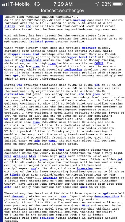
.SHORT TERM /6 PM THIS EVENING THROUGH TUESDAY NIGHT/...

Winter Storm Watch for Tuesday afternoon through Wednesday afternoon for the southern/western Adirondacks, western/central Mohawk Valley, the Lake George/Saratoga region and for all of southern VT...

Tuesday-Tuesday night, the storm system currently located across the NW U.S. will shift into the Plains and Great Lakes
region. A surge of strong isentropic lift will overspread the region by Tuesday afternoon from south to north. Initial thermal profiles suggest snow to start, which could be moderate to heavy in intensity. However, most models, especially the 00Z/10 NAM, suggest an elevated warm nose centered between roughly H800-700, with temps as warm as +2 to +4C.

In fact, the NAM would suggest above freezing temps within this layer encompass almost the entire region by 00Z/Wed. This would suggest a changeover to mainly sleet/freezing rain by Tuesday evening, even across northern areas, before cooling aloft allows precip to change back to snow overnight. The GFS, ECMWF and GEM are colder. Local case studies suggest the NAM tends to portray these elevated warm noses best, and therefore we are siding closer to the overall NAM thermal profiles. This would suggest more sleet/freezing rain for a period late Tuesday afternoon into the first half of Tuesday night, which would potentially cut down on snow totals, especially from the I-90 corridor and points
southward.

However, to the north, there remains more uncertainty regarding timing of any changeover, in addition to the
possibility that cooling aloft later Tuesday night/Wednesday morning allows for an additional several inches of snow. Thus, a Winter Storm Watch has been issued for northern areas, where this potential for greater snow totals (7 or more inches) exists. Elsewhere, still expect a burst of heavy snow once the snow starts, before changing to a wintry mix of sleet/freezing rain by late Tuesday afternoon into much of Tuesday night, before ending as snow late Tuesday night/Wednesday morning. Snow/sleet totals in these areas should remain below 7 inches. However, ice accretion from freezing rain could reach 0.10-0.25".
"You just need to go at that shit wide open, hang on, and own it." —Camp
Reply | Threaded
Open this post in threaded view
|

Re: Winter Weather 2018 - 2019

Harvey
Administrator
.LONG TERM /WEDNESDAY THROUGH SATURDAY/...

However, the next system will be quickly approaching for late Thursday night and continuing
through at least Friday.  There still are some timing differences within the models, but most guidance suggests another strong low pressure area will be taking a track west of the region across the Great Lakes once again.  

Unlike earlier in the week, there won`t be a cold air mass in place to start.  Still can expect a brief periods of snow or mixed precip to start (especially for northern areas), but precip will be quickly changing over to plain rain across the
region, as a strong southerly flow allows for much milder air (at both the surface and aloft) to rush into the region for Friday and Friday night.  Temps will be warming into the upper 30s to mid 40s and holding steady or rising for Friday night into Saturday.  There could be some locally heavy rainfall with this frontal system, as plenty of moisture will get pulled northward out of the Gulf of Mexico.   Behind the storm, colder air will work back into the region, allowing any lingering precip to change over to snow showers before ending.
"You just need to go at that shit wide open, hang on, and own it." —Camp
Reply | Threaded
Open this post in threaded view
|

Re: Winter Weather 2018 - 2019

JasonWx
I was holding off with that.. Mr P can't handle the reality of that..

If the weather pans out as forecasted , tue/wed's storm is irrelevant..
"Peace and Love"
Reply | Threaded
Open this post in threaded view
|

Re: Winter Weather 2018 - 2019

Harvey
Administrator
Only for we weekend warriors.
"You just need to go at that shit wide open, hang on, and own it." —Camp
Reply | Threaded
Open this post in threaded view
|

Re: Winter Weather 2018 - 2019

JTG4eva!
This post was updated on .
Wed and Thurs should be good, for those who can get out.....there’s that, at least.....maybe.
We REALLY need a proper roll eyes emoji!!
Reply | Threaded
Open this post in threaded view
|

Re: Winter Weather 2018 - 2019

JTG4eva!
In reply to this post by professor
professor wrote
...heading to Cali on Saturday...
How’s it going?  Hopefully the curse of too much snow isn’t skunking the weekend.  SquawAlpine picked up 3+ feet overnight and are closed today due to severe avy conditions.

Sugar Bowl picked up 29 in 24 and is open....
We REALLY need a proper roll eyes emoji!!
Reply | Threaded
Open this post in threaded view
|

Re: Winter Weather 2018 - 2019

Saratogahalfday
In reply to this post by JTG4eva!
For those looking for a Magic pow day on Wednesday, the entire mountain has been rented and is closed to the public.  

Thursday will be the day.
Reply | Threaded
Open this post in threaded view
|

Re: Winter Weather 2018 - 2019

PeeTex
It's looking like we could get as much as 2ft in the Southern Daks - wow.
Don't ski the trees, ski the spaces between the trees.
Reply | Threaded
Open this post in threaded view
|

Re: Winter Weather 2018 - 2019

Saratogahalfday
Where are you seeing that?  The NWS is calling for just over a foot there.    
Reply | Threaded
Open this post in threaded view
|

Re: Winter Weather 2018 - 2019

JasonWx
He's bust'n balls..

The NAM has warming at T5 all the way to BTV..This might be a problem..
"Peace and Love"
Reply | Threaded
Open this post in threaded view
|

Re: Winter Weather 2018 - 2019

JTG4eva!
In reply to this post by Saratogahalfday
Most forecasts I’ve seen put the upper end of the possible range at around 14 in the Dacks......with that possibly continuing to lower.  Enough warm air looks to creep up, bringing some mix with sleet, or worse, all the way to the Canadian border.


At least it will be a net positive event for the snowpack in a lot of places....
We REALLY need a proper roll eyes emoji!!
Reply | Threaded
Open this post in threaded view
|

Re: Winter Weather 2018 - 2019

JasonWx

Warm air usually wins..

On the flip side..The west is having a once a decade type of season..Almost every western ski mountain is getting rocked..
"Peace and Love"
1 ... 891011121314 ... 22